
Seller's Agent in 2026
Sarah Reynolds
Keller Williams Realty
(703) 844-3425
37 in this area
3,547 Total Sales

**ACCEPTING BACKUP OFFERS**
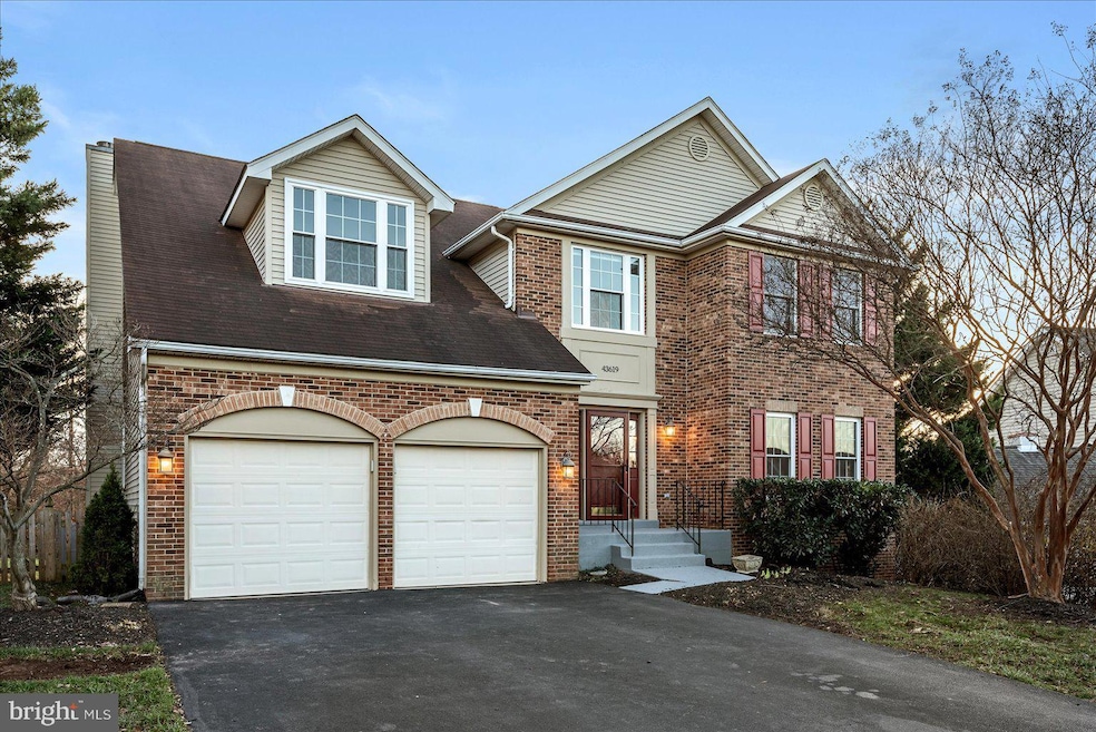
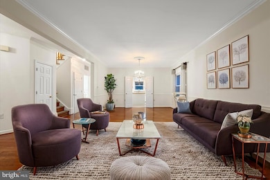
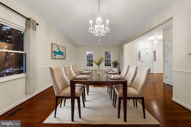
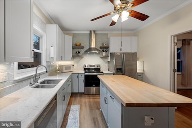
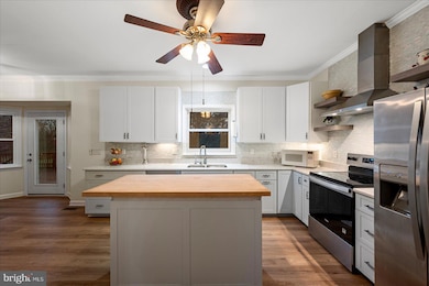
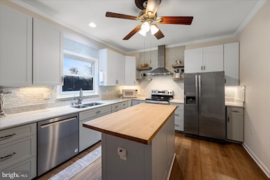
Beautifully maintained and thoughtfully designed, this home sits on a quiet cul-de-sac and backs to protected parkland, offering the rare combination of privacy, natural views, and neighborhood convenience. From the moment you arrive, the front-load attached garage and inviting exterior make an immediate impression, hinting at the comfort and livability found throughout the interior. Inside, the home features generous natural light, warm finishes, and a layout that supports both everyday routines and memorable gatherings. The spacious kitchen flows easily into the main living areas, creating an effortless environment for cooking, hosting, or simply enjoying time at home. The walk-out lower level provides incredible versatility—ideal for a recreation space, home office, fitness area, or guest retreat—with direct access to the backyard and wooded backdrop. Upstairs, the serene primary suite offers a peaceful escape, complete with a well-appointed bathroom featuring dual sinks and a separate shower for added comfort. Throughout the home, thoughtful upgrades, ample storage, and flexible spaces enhance its overall functionality. Outdoor living is equally inviting with a deck overlooking mature trees and community green space—perfect for morning coffee, evening relaxation, or casual entertaining. Backing to parkland ensures year-round tranquility and scenic views that set this property apart. Located in a sought-after Ashburn community close to parks, trails, shops, dining, and major commuter routes, this home blends convenience, natural beauty, and everyday comfort in an exceptional setting.
Last Agent to Sell the Property
(703) 679-1700 klrw319@kw.com Keller Williams Realty Brokerage Phone: 7036791700 License #0225174916 Listed on: 12/10/2025
Last Buyer's Agent
(703) 938-4200 longandfoster@broker1suite.com Long & Foster Real Estate, Inc. License #SP98369808
| Date | Type | Sale Price | Title Company |
|---|---|---|---|
| Deed | $970,000 | Title Resource Guaranty Compan | |
| Deed | -- | -- | |
| Deed | $227,713 | -- |
| Date | Status | Loan Amount | Loan Type |
|---|---|---|---|
| Open | $970,000 | VA | |
| Previous Owner | $21,000 | Credit Line Revolving | |
| Previous Owner | $182,150 | No Value Available |
| Date | Event | Price | List to Sale | Price per Sq Ft |
|---|---|---|---|---|
| 02/27/2026 02/27/26 | Sold | $970,000 | -1.5% | $258 / Sq Ft |
| 01/08/2026 01/08/26 | Price Changed | $985,000 | -1.5% | $262 / Sq Ft |
| 12/10/2025 12/10/25 | For Sale | $1,000,000 | -- | $266 / Sq Ft |
| Year | Tax Paid | Tax Assessment Tax Assessment Total Assessment is a certain percentage of the fair market value that is determined by local assessors to be the total taxable value of land and additions on the property. | Land | Improvement |
|---|---|---|---|---|
| 2025 | $6,838 | $849,490 | $300,600 | $548,890 |
| 2024 | $6,854 | $792,320 | $295,600 | $496,720 |
| 2023 | $6,819 | $779,340 | $295,600 | $483,740 |
| 2022 | $6,561 | $737,140 | $270,600 | $466,540 |
| 2021 | $6,290 | $641,810 | $220,600 | $421,210 |
| 2020 | $6,231 | $602,010 | $201,800 | $400,210 |
| 2019 | $6,167 | $590,170 | $201,800 | $388,370 |
| 2018 | $5,838 | $538,080 | $181,800 | $356,280 |
| 2017 | $5,914 | $525,650 | $181,800 | $343,850 |
| 2016 | $6,066 | $529,790 | $0 | $0 |
| 2015 | $5,888 | $336,950 | $0 | $336,950 |
| 2014 | $5,844 | $324,200 | $0 | $324,200 |
Seller's Agent in 2026
Sarah Reynolds
Keller Williams Realty
(703) 844-3425
37 in this area
3,547 Total Sales
Buyer's Agent in 2026
Elizabeth Sachero-Perez
Long & Foster
(703) 774-7448
1 in this area
26 Total Sales
Source: Bright MLS
MLS Number: VALO2111964
APN: 086-45-1071
Disclaimer: Certain information contained herein is derived from information provided by parties other than Homes.com. All information provided is deemed reliable, but is not guaranteed to be accurate and should be independently verified.
![]() The data relating to real estate for sale on this website appears in part through the BRIGHT Internet Data Exchange program, a voluntary cooperative exchange of property listing data between licensed real estate brokerage firms, and is provided by BRIGHT through a licensing agreement.
The data relating to real estate for sale on this website appears in part through the BRIGHT Internet Data Exchange program, a voluntary cooperative exchange of property listing data between licensed real estate brokerage firms, and is provided by BRIGHT through a licensing agreement.
Listing information is from various brokers who participate in the Bright MLS IDX program and not all listings may be visible on the site.
The property information being provided on or through the website is for the personal, non-commercial use of consumers and such information may not be used for any purpose other than to identify prospective properties consumers may be interested in purchasing.
Some properties which appear for sale on the website may no longer be available because they are for instance, under contract, sold or are no longer being offered for sale.
Property information displayed is deemed reliable but is not guaranteed.
Copyright 2026 Bright MLS, Inc.
Ask me questions while you tour the home.