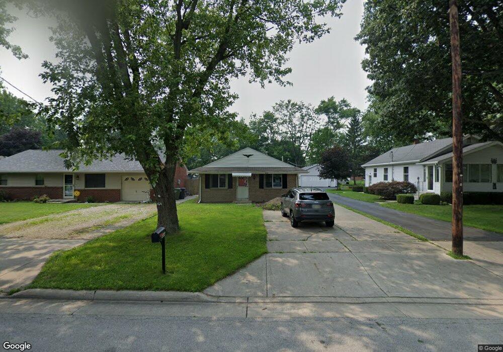
4364 Carney Dr Maumee, OH 43537
Estimated Value: $178,968 - $220,000
3
Beds
2
Baths
1,215
Sq Ft
$159/Sq Ft
Est. Value
About This Home
This home is located at 4364 Carney Dr, Maumee, OH 43537 and is currently estimated at $192,992, approximately $158 per square foot. 4364 Carney Dr is a home located in Lucas County with nearby schools including Maumee Intermediate School, Fairfield Elementary School, and Maumee Middle School.
Ownership History
Date
Name
Owned For
Owner Type
Purchase Details
Closed on
Jun 2, 2014
Sold by
Meyers William J
Bought by
Iacino Kelly Jo
Current Estimated Value
Purchase Details
Closed on
Mar 3, 2006
Sold by
Robbins Margaret
Bought by
Meyers William J and Meyers Arlene
Home Financials for this Owner
Home Financials are based on the most recent Mortgage that was taken out on this home.
Original Mortgage
$78,400
Interest Rate
8.5%
Mortgage Type
Fannie Mae Freddie Mac
Purchase Details
Closed on
May 19, 2005
Sold by
Robbins Bill J
Bought by
Robbins Margaret
Purchase Details
Closed on
Sep 29, 2003
Sold by
Tinney William C
Bought by
Robbins Bill J and Robbins Margaret
Home Financials for this Owner
Home Financials are based on the most recent Mortgage that was taken out on this home.
Original Mortgage
$40,000
Interest Rate
6.43%
Mortgage Type
Purchase Money Mortgage
Create a Home Valuation Report for This Property
The Home Valuation Report is an in-depth analysis detailing your home's value as well as a comparison with similar homes in the area
Home Values in the Area
Average Home Value in this Area
Purchase History
| Date | Buyer | Sale Price | Title Company |
|---|---|---|---|
| Iacino Kelly Jo | $48,000 | None Available | |
| Meyers William J | $112,000 | Netco | |
| Robbins Margaret | -- | -- | |
| Robbins Bill J | $100,000 | Northwest Title Agency Of Oh |
Source: Public Records
Mortgage History
| Date | Status | Borrower | Loan Amount |
|---|---|---|---|
| Previous Owner | Meyers William J | $78,400 | |
| Previous Owner | Robbins Bill J | $40,000 |
Source: Public Records
Tax History
| Year | Tax Paid | Tax Assessment Tax Assessment Total Assessment is a certain percentage of the fair market value that is determined by local assessors to be the total taxable value of land and additions on the property. | Land | Improvement |
|---|---|---|---|---|
| 2025 | -- | $41,580 | $5,775 | $35,805 |
| 2024 | $1,342 | $41,580 | $5,775 | $35,805 |
| 2023 | $2,743 | $36,330 | $5,040 | $31,290 |
| 2022 | $2,440 | $36,330 | $5,040 | $31,290 |
| 2021 | $2,577 | $36,330 | $5,040 | $31,290 |
| 2020 | $2,649 | $33,250 | $4,585 | $28,665 |
| 2019 | $2,583 | $33,250 | $4,585 | $28,665 |
| 2018 | $2,421 | $33,250 | $4,585 | $28,665 |
| 2017 | $2,304 | $29,400 | $6,860 | $22,540 |
| 2016 | $2,278 | $84,000 | $19,600 | $64,400 |
| 2015 | $2,267 | $84,000 | $19,600 | $64,400 |
| 2014 | $2,578 | $35,180 | $6,860 | $28,320 |
| 2013 | $2,578 | $35,180 | $6,860 | $28,320 |
Source: Public Records
Map
Nearby Homes
- 948 Joliet Dr
- 6002 Monclova Rd
- 426 W Wayne St
- 26976 W River Rd
- 26781 Riverford Dr
- 26766 Riverford Dr
- 26755 Riverford Dr
- 212 E Indiana Ave
- 213 E Indiana Ave
- 224 Sackett St
- 408 Clinton St
- 501 Chippewa Ln
- 509 Chippewa Ln
- 494 Delaware Dr
- 422 Delaware Dr
- 470 Delaware Dr
- 446 Delaware Dr
- 478 Delaware Dr
- 414 Delaware Dr
- 486 Delaware Dr
Your Personal Tour Guide
Ask me questions while you tour the home.