Estimated Value: $516,731 - $617,000
4
Beds
3
Baths
1,812
Sq Ft
$316/Sq Ft
Est. Value
About This Home
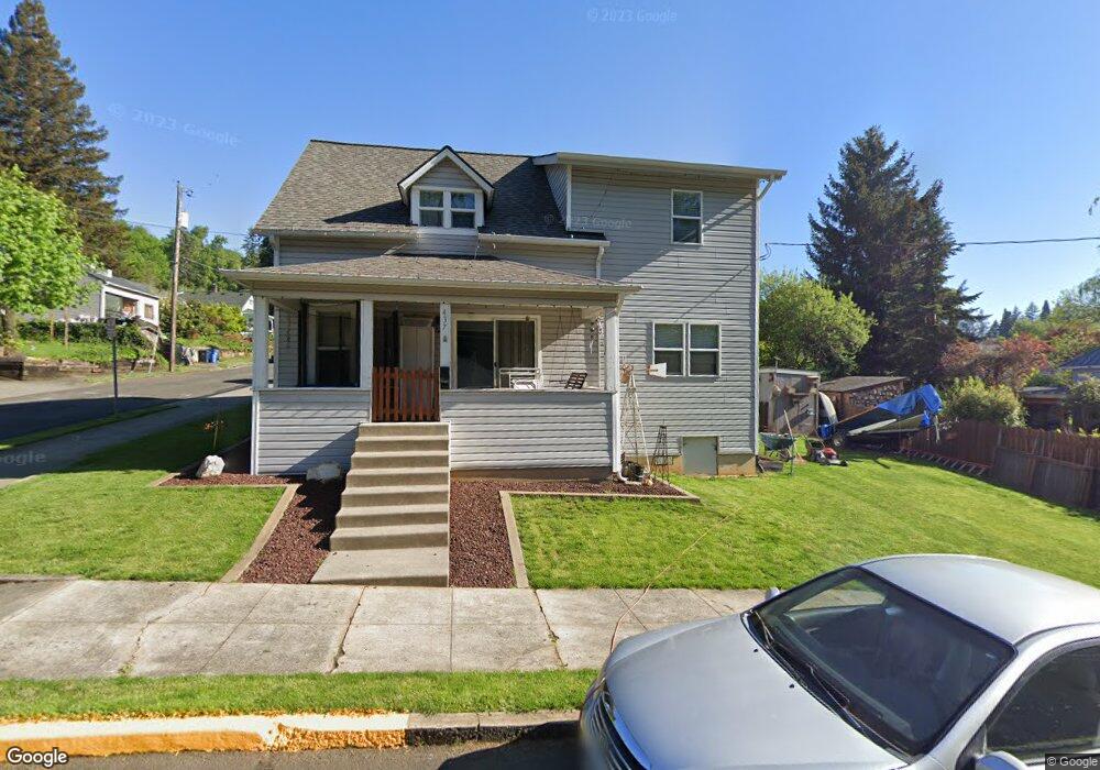
This home is located at 437 NW 12th Ave, Camas, WA 98607 and is currently estimated at $572,183, approximately $315 per square foot. 437 NW 12th Ave is a home located in Clark County with nearby schools including Helen Baller Elementary School, Liberty Middle School, and Camas High School.
Ownership History
Date
Name
Owned For
Owner Type
Purchase Details
Closed on
Nov 16, 2001
Sold by
Brandon Joanne B
Bought by
Curtis Larry D and Curtis Penny M
Current Estimated Value
Purchase Details
Closed on
Mar 26, 1998
Sold by
Hughes Ann Morgan and Smith Carol Morgan
Bought by
Brandon Raymond R and Brandon Joanne Rose
Purchase Details
Closed on
Jan 15, 1996
Sold by
Curtis Larry D and Curtis Penny M
Bought by
Brandon Joanne B
Create a Home Valuation Report for This Property
The Home Valuation Report is an in-depth analysis detailing your home's value as well as a comparison with similar homes in the area
Home Values in the Area
Average Home Value in this Area
Purchase History
| Date | Buyer | Sale Price | Title Company |
|---|---|---|---|
| Curtis Larry D | -- | First American Title Ins Co | |
| Brandon Raymond R | -- | -- | |
| Brandon Joanne B | -- | Chicago Title Insurance Co |
Source: Public Records
Tax History Compared to Growth
Tax History
| Year | Tax Paid | Tax Assessment Tax Assessment Total Assessment is a certain percentage of the fair market value that is determined by local assessors to be the total taxable value of land and additions on the property. | Land | Improvement |
|---|---|---|---|---|
| 2025 | $4,372 | $398,055 | $107,240 | $290,815 |
| 2024 | $4,190 | $458,401 | $163,005 | $295,396 |
| 2023 | $4,526 | $490,675 | $166,222 | $324,453 |
| 2022 | $4,444 | $485,266 | $159,788 | $325,478 |
| 2021 | $4,207 | $398,235 | $130,833 | $267,402 |
| 2020 | $4,310 | $349,460 | $113,674 | $235,786 |
| 2019 | $3,787 | $332,006 | $107,240 | $224,766 |
| 2018 | $2,316 | $310,734 | $0 | $0 |
| 2017 | $1,884 | $159,619 | $0 | $0 |
| 2016 | $1,680 | $141,376 | $0 | $0 |
| 2015 | $1,666 | $125,398 | $0 | $0 |
| 2014 | -- | $117,245 | $0 | $0 |
| 2013 | -- | $106,642 | $0 | $0 |
Source: Public Records
Map
Nearby Homes
- 1123 NW Ash St
- 536 NW 10th Ave
- 441 NW 15th Ave
- 527 NW 9th Ave
- 535 NW 9th Ave
- 1303 Division St
- 715 NW 10th Ave
- 912 NW Fargo St
- 541 NW 8th Ave
- 615 NW 7th Ave
- 1623 Division St
- 907 NW Greeley St
- 124 NW 18th Ave
- 222 NW 19th Ave
- 719 NE Dallas St Unit A4
- 802 NW 5th Cir Unit 802
- 2052 NW Fargo Loop
- 634 NW 5th Ave
- 737 NW 20th Ave
- 2120 NW Fargo Loop
- 1224 NW Drake Way
- 436 NW 12th Ave
- 1203 NW Drake Way
- 1234 NW Drake Way
- 430 NW 12th Ave
- 1225 NW Drake Way
- 1215 NW Couch St
- 448 NW 12th Ave
- 1241 NW Couch St
- 1233 NW Drake Way
- 1243 NW Couch St
- 1244 NW Drake Way
- 0 NW Drake Way
- 345 NW 12th Ave
- 1241 NW Drake Way
- 1301 NW Couch St
- 1304 NW Drake Way
- 1313 NW Couch St
- 1228 NW Couch St Unit 1228
- 325 NW 12th Ave