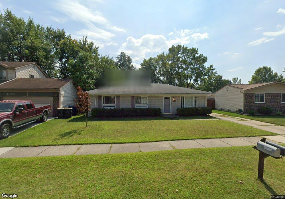
43721 Yorktown St Canton, MI 48188
Estimated Value: $260,000 - $314,000
3
Beds
1
Bath
1,200
Sq Ft
$244/Sq Ft
Est. Value
About This Home
This home is located at 43721 Yorktown St, Canton, MI 48188 and is currently estimated at $293,074, approximately $244 per square foot. 43721 Yorktown St is a home located in Wayne County with nearby schools including Bentley Elementary School, Canton High School, and Salem High School.
Ownership History
Date
Name
Owned For
Owner Type
Purchase Details
Closed on
Dec 1, 2014
Sold by
Zeigler Marvin B and Zeigler Deborah A
Bought by
Zeigler Deborah A
Current Estimated Value
Purchase Details
Closed on
Jan 17, 2004
Sold by
Goodsell Carie L
Bought by
Goodsell Michael N
Purchase Details
Closed on
Sep 27, 1999
Sold by
Kott John P
Bought by
Goodsell Carie Goodsell
Purchase Details
Closed on
Oct 21, 1997
Sold by
Cullen John A and Cullen Karen A
Bought by
Kott John P
Create a Home Valuation Report for This Property
The Home Valuation Report is an in-depth analysis detailing your home's value as well as a comparison with similar homes in the area
Home Values in the Area
Average Home Value in this Area
Purchase History
| Date | Buyer | Sale Price | Title Company |
|---|---|---|---|
| Zeigler Deborah A | -- | None Available | |
| Goodsell Michael N | -- | Title Source Inc | |
| Goodsell Carie Goodsell | $127,000 | -- | |
| Kott John P | $102,000 | -- | |
| Kott John P | $102,000 | -- |
Source: Public Records
Tax History Compared to Growth
Tax History
| Year | Tax Paid | Tax Assessment Tax Assessment Total Assessment is a certain percentage of the fair market value that is determined by local assessors to be the total taxable value of land and additions on the property. | Land | Improvement |
|---|---|---|---|---|
| 2025 | $1,333 | $125,100 | $0 | $0 |
| 2024 | $1,333 | $119,200 | $0 | $0 |
| 2023 | $1,271 | $108,400 | $0 | $0 |
| 2022 | $2,893 | $93,500 | $0 | $0 |
| 2021 | $2,810 | $90,800 | $0 | $0 |
| 2020 | $2,728 | $85,600 | $0 | $0 |
| 2019 | $2,681 | $81,860 | $0 | $0 |
| 2018 | $1,080 | $72,670 | $0 | $0 |
| 2017 | $2,791 | $70,700 | $0 | $0 |
| 2016 | $2,444 | $68,900 | $0 | $0 |
| 2015 | $5,936 | $63,690 | $0 | $0 |
| 2013 | $5,750 | $61,220 | $0 | $0 |
| 2010 | -- | $52,090 | $31,225 | $20,865 |
Source: Public Records
Map
Nearby Homes
- 1619 Nowland Ct
- 43661 Antietam Ct
- 43664 Appomattox Ct
- 43450 Fredericksburg St
- 1937 S Cavalier Dr
- 43592 Champlain Ct
- 1834 Maple Park Dr W Unit 9
- 2349 Abbey Ct
- 2562 Woodmont Dr E
- 550 Cherry Grove Rd Unit 111
- 45242 Thornhill Rd
- 1530 Fairfax Dr
- 45030 Glengarry Rd
- 2210 Woodmont Dr W
- 550 Concord Dr Unit 75
- 603 Concord Dr Unit 67
- 139 Concord Dr
- 2785 Woodmont Dr E
- 2435 Woodmont Dr W
- 278 Cornell St
- 43715 Yorktown St
- 43727 Yorktown St
- 43709 Yorktown St
- 43790 Nowland Dr
- 43828 Nowland Dr
- 43739 Verdun Ct
- 43743 Verdun Ct
- 43866 Nowland Dr
- 43703 Yorktown St
- 43722 Yorktown St
- 43716 Yorktown St
- 43728 Yorktown St
- 43710 Yorktown St
- 43904 Nowland Dr
- 43774 Nowland Dr
- 43697 Yorktown St
- 43704 Yorktown St
- 43763 Nowland Dr
- 43691 Yorktown St