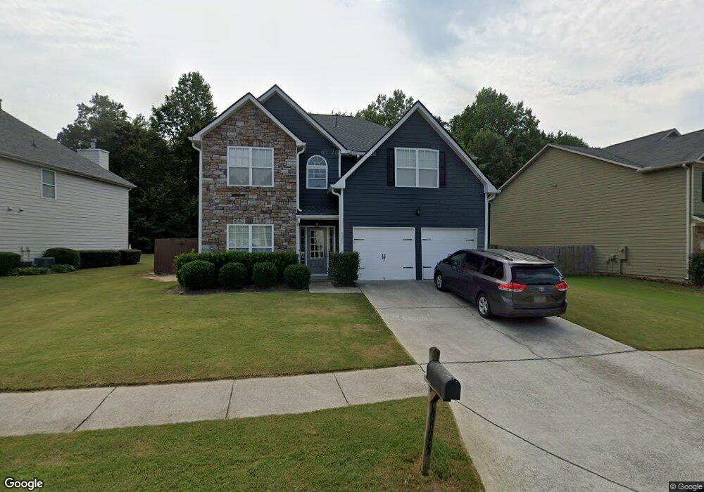
4375 Mill Farm Ln Buford, GA 30519
Estimated Value: $459,390 - $521,000
3
Beds
3
Baths
3,028
Sq Ft
$159/Sq Ft
Est. Value
About This Home
This home is located at 4375 Mill Farm Ln, Buford, GA 30519 and is currently estimated at $480,598, approximately $158 per square foot. 4375 Mill Farm Ln is a home located in Gwinnett County with nearby schools including Duncan Creek Elementary School, Frank N. Osborne Middle School, and Mill Creek High School.
Ownership History
Date
Name
Owned For
Owner Type
Purchase Details
Closed on
Jun 17, 2008
Sold by
Atreus Communities Of Northeas
Bought by
Deignan William D and Deignan Lisa A
Current Estimated Value
Home Financials for this Owner
Home Financials are based on the most recent Mortgage that was taken out on this home.
Original Mortgage
$217,762
Outstanding Balance
$137,943
Interest Rate
5.97%
Mortgage Type
FHA
Estimated Equity
$342,655
Create a Home Valuation Report for This Property
The Home Valuation Report is an in-depth analysis detailing your home's value as well as a comparison with similar homes in the area
Home Values in the Area
Average Home Value in this Area
Purchase History
| Date | Buyer | Sale Price | Title Company |
|---|---|---|---|
| Deignan William D | $221,200 | -- |
Source: Public Records
Mortgage History
| Date | Status | Borrower | Loan Amount |
|---|---|---|---|
| Open | Deignan William D | $217,762 |
Source: Public Records
Tax History Compared to Growth
Tax History
| Year | Tax Paid | Tax Assessment Tax Assessment Total Assessment is a certain percentage of the fair market value that is determined by local assessors to be the total taxable value of land and additions on the property. | Land | Improvement |
|---|---|---|---|---|
| 2025 | $5,135 | $189,240 | $44,000 | $145,240 |
| 2024 | $4,924 | $170,440 | $36,400 | $134,040 |
| 2023 | $4,924 | $188,080 | $36,400 | $151,680 |
| 2022 | $4,501 | $151,560 | $26,000 | $125,560 |
| 2021 | $3,734 | $111,760 | $21,880 | $89,880 |
| 2020 | $3,759 | $111,760 | $21,880 | $89,880 |
| 2019 | $3,395 | $100,040 | $18,000 | $82,040 |
| 2018 | $3,399 | $100,040 | $18,000 | $82,040 |
| 2016 | $3,136 | $87,000 | $15,600 | $71,400 |
| 2015 | $3,168 | $87,000 | $15,600 | $71,400 |
| 2014 | $3,059 | $82,520 | $15,600 | $66,920 |
Source: Public Records
Map
Nearby Homes
- 4457 Water Mill Dr
- 2206 Spring Stone Ct
- 4271 Haywater Cove
- 2171 Spring Sound Ln
- 4657 Water Mill Dr NE
- 2200 Spring Sound Ln
- 4777 Waxwing St
- 4335 Magpie Dr
- 4602 Shay Terrace
- 4335 Braselton Hwy Unit tax parcel R3003 327
- 4785 Nolans Ridge
- 3475 Duncan Bridge Dr Unit 2
- 2415 Hamilton Parc Ln
- 2485 Hamilton Parc Ln
- 4162 Wyndham Ridge Ct Unit 3
- 1661 Silver Crest Way
- 2114 Sorrento Ct
- 4365 Mill Farm Ln
- 4365 Mill Farm Ln Unit 25
- 4385 Mill Farm Ln
- 0 Mill Farm Ln NE Unit 8480314
- 0 Mill Farm Ln NE Unit 8236842
- 0 Mill Farm Ln NE Unit 8284278
- 0 Mill Farm Ln NE Unit 8233896
- 0 Mill Farm Ln NE Unit 9066124
- 0 Mill Farm Ln NE Unit 7396053
- 0 Mill Farm Ln NE
- 4405 Mill Farm Ln
- 4345 Mill Farm Ln
- 4372 Mill Farm Ln
- 4382 Mill Farm Ln
- 4362 Mill Farm Ln
- 4392 Mill Farm Ln
- 4335 Mill Farm Ln NE
- 4352 Mill Farm Ln
- 2108 Water Mill Ct
- 4415 Mill Farm Ln