J
Seller's Agent in 2025
Jeanne Coyle
Real Estate One
(313) 530-6870
3 in this area
26 Total Sales
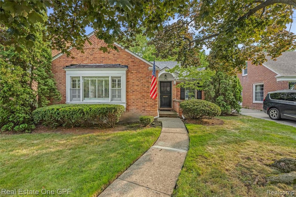
Not your run of the mill 2 bedroom 1.5 bath ranch! This one has curb appeal, charm, and character plus a stellar Grosse Pointe Farms location nestled deep on a quiet court yet close to schools and shopping. Step inside to a vestibule that leads to a large formal living room with a cozy gas fireplace and dining room that flows effortlessly off the living space. Hardwood floors throughout and lots of storage space. The kitchen features newer appliances and a cherry breakfast nook. One bedroom includes its own private adjoining bath and the full bath is centrally located for convenience. A true bonus is the heated 4 seasons room offering picture perfect views of the well landscaped manageable back yard with a patio. Head downstairs to a rec room complete with a bar and 1/2 bath. Perfect for the sizing down or first time buyer and great condo alternative! Certificate of Occupancy has been completed.
Last Agent to Sell the Property
Real Estate One GPF License #6501206329 Listed on: 07/28/2025

| Date | Type | Sale Price | Title Company |
|---|---|---|---|
| Warranty Deed | $310,000 | Capital Title | |
| Interfamily Deed Transfer | -- | None Available | |
| Interfamily Deed Transfer | -- | Metropolitan Title Company | |
| Deed | $160,000 | -- |
| Date | Status | Loan Amount | Loan Type |
|---|---|---|---|
| Open | $288,300 | New Conventional | |
| Previous Owner | $7,500 | Credit Line Revolving |
| Date | Event | Price | List to Sale | Price per Sq Ft |
|---|---|---|---|---|
| 08/18/2025 08/18/25 | Sold | $310,000 | -3.1% | $223 / Sq Ft |
| 08/07/2025 08/07/25 | Pending | -- | -- | -- |
| 07/28/2025 07/28/25 | For Sale | $320,000 | -- | $231 / Sq Ft |
| Year | Tax Paid | Tax Assessment Tax Assessment Total Assessment is a certain percentage of the fair market value that is determined by local assessors to be the total taxable value of land and additions on the property. | Land | Improvement |
|---|---|---|---|---|
| 2025 | $2,740 | $162,500 | $0 | $0 |
| 2024 | $2,740 | $148,600 | $0 | $0 |
| 2023 | $2,510 | $136,500 | $0 | $0 |
| 2022 | $2,510 | $125,700 | $0 | $0 |
| 2021 | $4,606 | $116,100 | $0 | $0 |
| 2019 | $4,529 | $104,700 | $0 | $0 |
| 2018 | $2,318 | $96,600 | $0 | $0 |
| 2017 | $4,022 | $94,200 | $0 | $0 |
| 2016 | $4,216 | $92,500 | $0 | $0 |
| 2015 | $8,351 | $92,100 | $0 | $0 |
| 2013 | $8,090 | $80,900 | $0 | $0 |
| 2012 | $2,153 | $80,900 | $23,400 | $57,500 |
J
Seller's Agent in 2025
Jeanne Coyle
Real Estate One
(313) 530-6870
3 in this area
26 Total Sales
Buyer's Agent in 2025
Brittany Schreck
Quest Realty LLC
(248) 842-4676
1 in this area
74 Total Sales
Source: Realcomp
MLS Number: 20251021317
APN: 38-001-04-0042-000
Disclaimer: Certain information contained herein is derived from information provided by parties other than Homes.com. All information provided is deemed reliable, but is not guaranteed to be accurate and should be independently verified.
![]() IDX provided courtesy of Realcomp II Ltd. via Ten-X and MLS
IDX provided courtesy of Realcomp II Ltd. via Ten-X and MLS
Copyright 2025 Realcomp II Ltd. Shareholders
IDX information is provided exclusively for consumers' personal, noncommercial use and may not be used for any purpose other than to identify prospective properties consumers may be interested in purchasing. The accuracy of all information, regardless of source, is not guaranteed or warranted. All information should be independently verified.
Listing Information presented by local MLS brokerage: Ten-X, local REALTOR®- Arlene Richardson - (888)-952-6393