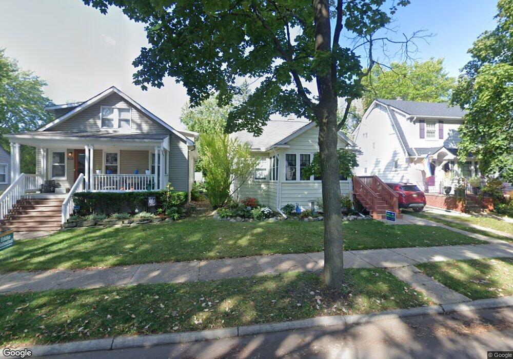
438 Leroy St Ferndale, MI 48220
Estimated Value: $335,319 - $391,000
3
Beds
2
Baths
1,480
Sq Ft
$246/Sq Ft
Est. Value
About This Home
This home is located at 438 Leroy St, Ferndale, MI 48220 and is currently estimated at $364,580, approximately $246 per square foot. 438 Leroy St is a home located in Oakland County with nearby schools including Ferndale Lower Elementary Campus, Ferndale Upper Elementary Campus, and Ferndale Middle School.
Ownership History
Date
Name
Owned For
Owner Type
Purchase Details
Closed on
Sep 7, 2023
Sold by
Romas Francisco David and Romas Jennifer L
Bought by
Romas Francisco David and Bondy Jennifer L
Current Estimated Value
Purchase Details
Closed on
Sep 15, 2015
Sold by
Romas Francisco David and Bondy Jennifer L
Bought by
Romas Bondy Revocable Living Trust and Bondy Jennifer L
Purchase Details
Closed on
Oct 28, 2003
Sold by
Kennedy Margaret A
Bought by
Romas Francisco David and Bondy Jennifer L
Purchase Details
Closed on
Nov 13, 1995
Sold by
Hutchinson Martin A
Bought by
Kennedy Margaret A
Home Financials for this Owner
Home Financials are based on the most recent Mortgage that was taken out on this home.
Original Mortgage
$76,650
Interest Rate
7.56%
Create a Home Valuation Report for This Property
The Home Valuation Report is an in-depth analysis detailing your home's value as well as a comparison with similar homes in the area
Home Values in the Area
Average Home Value in this Area
Purchase History
| Date | Buyer | Sale Price | Title Company |
|---|---|---|---|
| Romas Francisco David | $335,000 | None Listed On Document | |
| Romas Francisco David | $335,000 | None Listed On Document | |
| Romas Bondy Revocable Living Trust | -- | Attorney | |
| Romas Francisco David | -- | Professional Real Estate Tit | |
| Kennedy Margaret A | $90,000 | -- |
Source: Public Records
Mortgage History
| Date | Status | Borrower | Loan Amount |
|---|---|---|---|
| Previous Owner | Kennedy Margaret A | $76,650 |
Source: Public Records
Tax History Compared to Growth
Tax History
| Year | Tax Paid | Tax Assessment Tax Assessment Total Assessment is a certain percentage of the fair market value that is determined by local assessors to be the total taxable value of land and additions on the property. | Land | Improvement |
|---|---|---|---|---|
| 2024 | $7,335 | $145,180 | $0 | $0 |
| 2023 | $3,347 | $121,890 | $0 | $0 |
| 2022 | $3,356 | $110,890 | $0 | $0 |
| 2021 | $3,375 | $100,690 | $0 | $0 |
| 2020 | $3,204 | $95,650 | $0 | $0 |
| 2019 | $3,253 | $84,890 | $0 | $0 |
| 2018 | $3,263 | $75,000 | $0 | $0 |
| 2017 | $3,222 | $73,450 | $0 | $0 |
| 2016 | $3,184 | $69,080 | $0 | $0 |
| 2015 | -- | $64,860 | $0 | $0 |
| 2014 | -- | $55,770 | $0 | $0 |
| 2011 | -- | $52,820 | $0 | $0 |
Source: Public Records
Map
Nearby Homes
- 324 Albany St
- 571 W Saratoga St
- 487 W Troy St
- 816 Pearson St
- 855 Allen St
- 630 W Troy St
- 853 Leroy St
- 256 Withington St
- 475 W Breckenridge St
- 619 Withington St
- 918 Saint Louis St
- 211 E 9 Mile Rd Unit 311
- 367 W Cambourne St
- 1709 Beaufield St
- 964 W Marshall St
- 695 Livernois St
- 341 E Saratoga St
- 271 College St
- 203 E Lewiston Ave
- 559 Gardendale St