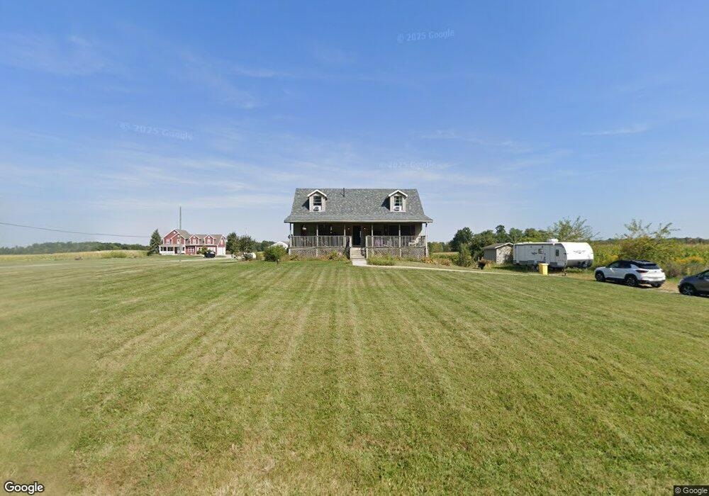
4382 Snodgrass Rd Mansfield, OH 44903
Estimated Value: $133,000 - $253,000
3
Beds
2
Baths
1,120
Sq Ft
$181/Sq Ft
Est. Value
About This Home
This home is located at 4382 Snodgrass Rd, Mansfield, OH 44903 and is currently estimated at $202,893, approximately $181 per square foot. 4382 Snodgrass Rd is a home located in Richland County with nearby schools including Stingel Elementary School, Ontario Middle School, and Ontario High School.
Ownership History
Date
Name
Owned For
Owner Type
Purchase Details
Closed on
May 18, 1999
Sold by
Billy H Music
Bought by
Chandler David W and Chandler Kimberly D
Current Estimated Value
Home Financials for this Owner
Home Financials are based on the most recent Mortgage that was taken out on this home.
Original Mortgage
$79,800
Outstanding Balance
$20,619
Interest Rate
7.04%
Mortgage Type
New Conventional
Estimated Equity
$182,274
Create a Home Valuation Report for This Property
The Home Valuation Report is an in-depth analysis detailing your home's value as well as a comparison with similar homes in the area
Home Values in the Area
Average Home Value in this Area
Purchase History
| Date | Buyer | Sale Price | Title Company |
|---|---|---|---|
| Chandler David W | $12,000 | -- |
Source: Public Records
Mortgage History
| Date | Status | Borrower | Loan Amount |
|---|---|---|---|
| Open | Chandler David W | $79,800 |
Source: Public Records
Tax History Compared to Growth
Tax History
| Year | Tax Paid | Tax Assessment Tax Assessment Total Assessment is a certain percentage of the fair market value that is determined by local assessors to be the total taxable value of land and additions on the property. | Land | Improvement |
|---|---|---|---|---|
| 2024 | $2,452 | $49,210 | $9,090 | $40,120 |
| 2023 | $2,452 | $49,210 | $9,090 | $40,120 |
| 2022 | $2,347 | $40,530 | $8,260 | $32,270 |
| 2021 | $2,351 | $40,530 | $8,260 | $32,270 |
| 2020 | $2,510 | $40,530 | $8,260 | $32,270 |
| 2019 | $2,351 | $34,350 | $7,000 | $27,350 |
| 2018 | $1,995 | $34,350 | $7,000 | $27,350 |
| 2017 | $1,964 | $34,350 | $7,000 | $27,350 |
| 2016 | $2,037 | $35,410 | $6,790 | $28,620 |
| 2015 | $2,035 | $35,410 | $6,790 | $28,620 |
| 2014 | $2,038 | $35,410 | $6,790 | $28,620 |
| 2012 | $1,911 | $36,510 | $7,000 | $29,510 |
Source: Public Records
Map
Nearby Homes
- 4825 Lincoln Hwy
- 4451 Beam Rd
- 832 State Route 314 N
- 1671 State Route 314 N
- 1689 Ohio 314
- 1689 State Route 314
- 5263 Lincoln Hwy
- 5380 Lincoln Hwy
- 5446 Lincoln Hwy
- 5450 Lincoln Hwy
- 0 Rudy Rd
- 3880 Horizon Dr
- 1260 Thrush Rd
- 3251 Cookton Grange Rd
- 0 Alexander Dr
- 56 Lexington Ontario Rd
- 3436 Ridgestone Ct
- 3541 Oakstone Dr
- 3308 Park Ave W
- 3320 Oakstone Dr
- 4420 Snodgrass Rd
- 4411 Snodgrass Rd
- 4402 Snodgrass Rd
- 1086 Eckstein Rd
- 4450 Snodgrass Rd
- 4310 Snodgrass Rd
- 4250 Snodgrass Rd
- 4520 Snodgrass Rd
- 4205 Snodgrass Rd
- 749 Eckstein Rd
- 4554 Snodgrass Rd
- 4138 Snodgrass Rd
- 4601 Lincoln Hwy
- 1171 Walcrest Dr
- 1181 Walcrest Dr
- 1191 Walcrest Dr
- 4623 Lincoln Hwy
- 4120 Snodgrass Rd
- 4623 Lincoln Hwy
- 1201 Walcrest Dr