
Seller's Agent in 2025
Barbara Hendrick
Coldwell Banker Real Estate Group
(260) 833-4698
199 Total Sales


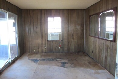
Enjoy 115 feet of level lakefront on Jimmerson Lake with wide-open sunset views. This 2-bedroom, 1-bath cottage offers 672 sq ft and includes an enclosed lakeside porch ideal for morning coffee or evening sunsets. Whether you’re looking to renovate or rebuild, this property offers flexible options for seasonal use or long-term plans. Located near the lively 4-corner area of Lake James and Jimmerson Lake, you’ll be steps from local favorites like Tom’s Donuts, the bait shop, restaurants, and pubs. Quick access to I-69 and the Toll Road makes weekend getaways easy. Selling as-is with no warranties except for title. This is an estate and there are no disclosures.
Last Agent to Sell the Property
Coldwell Banker Real Estate Group Brokerage Phone: 260-833-4698 Listed on: 11/14/2025
Last Buyer's Agent
Coldwell Banker Real Estate Group Brokerage Phone: 260-833-4698 Listed on: 11/14/2025
| Date | Type | Sale Price | Title Company |
|---|---|---|---|
| Interfamily Deed Transfer | -- | Metropolitan Title Of Indian |
| Date | Status | Loan Amount | Loan Type |
|---|---|---|---|
| Closed | $150,000 | New Conventional |
| Date | Event | Price | List to Sale | Price per Sq Ft |
|---|---|---|---|---|
| 12/04/2025 12/04/25 | Sold | $450,000 | +4.7% | $670 / Sq Ft |
| 11/18/2025 11/18/25 | Pending | -- | -- | -- |
| 11/14/2025 11/14/25 | For Sale | $430,000 | -- | $640 / Sq Ft |
| Year | Tax Paid | Tax Assessment Tax Assessment Total Assessment is a certain percentage of the fair market value that is determined by local assessors to be the total taxable value of land and additions on the property. | Land | Improvement |
|---|---|---|---|---|
| 2024 | $2,086 | $502,300 | $434,900 | $67,400 |
| 2023 | $1,546 | $309,000 | $257,400 | $51,600 |
| 2022 | $1,699 | $305,400 | $257,400 | $48,000 |
| 2021 | $1,593 | $284,700 | $240,500 | $44,200 |
| 2020 | $1,497 | $249,100 | $212,700 | $36,400 |
| 2019 | $1,799 | $285,400 | $255,300 | $30,100 |
| 2018 | $1,944 | $199,100 | $170,200 | $28,900 |
| 2017 | $2,256 | $229,400 | $201,800 | $27,600 |
| 2016 | $2,110 | $230,800 | $201,800 | $29,000 |
| 2014 | $1,642 | $226,400 | $201,800 | $24,600 |
| 2013 | $1,642 | $226,700 | $201,800 | $24,900 |
Seller's Agent in 2025
Barbara Hendrick
Coldwell Banker Real Estate Group
(260) 833-4698
199 Total Sales
Source: Indiana Regional MLS
MLS Number: 202546010
APN: 76-03-32-410-316.000-006
Disclaimer: Certain information contained herein is derived from information provided by parties other than Homes.com. All information provided is deemed reliable, but is not guaranteed to be accurate and should be independently verified.
![]() IDX information is provided exclusively for personal, non-commercial use, and may not be used for any purpose other than to identify prospective properties consumers may be interested in purchasing. Information is deemed reliable but not guaranteed.
IDX information is provided exclusively for personal, non-commercial use, and may not be used for any purpose other than to identify prospective properties consumers may be interested in purchasing. Information is deemed reliable but not guaranteed.