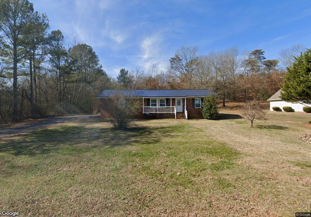
439 Spring Valley Dr SW Unit 40 Calhoun, GA 30701
Estimated Value: $159,000 - $240,000
3
Beds
1
Bath
1,458
Sq Ft
$137/Sq Ft
Est. Value
About This Home
This home is located at 439 Spring Valley Dr SW Unit 40, Calhoun, GA 30701 and is currently estimated at $199,825, approximately $137 per square foot. 439 Spring Valley Dr SW Unit 40 is a home located in Gordon County with nearby schools including Calhoun Elementary School, Calhoun Middle School, and Calhoun High School.
Ownership History
Date
Name
Owned For
Owner Type
Purchase Details
Closed on
Feb 28, 2014
Sold by
Sec Of Housing & U
Bought by
Lam Hop Sum and Nguyen Diem Thuy Thi
Current Estimated Value
Purchase Details
Closed on
Aug 6, 2013
Sold by
Wells Fargo Bank
Bought by
Sec Of Housing & Urban
Purchase Details
Closed on
Apr 15, 2005
Sold by
Wooten Jackie
Bought by
Ramirez Jose G
Home Financials for this Owner
Home Financials are based on the most recent Mortgage that was taken out on this home.
Original Mortgage
$85,027
Interest Rate
5.88%
Mortgage Type
FHA
Purchase Details
Closed on
Jul 30, 1998
Bought by
Wooten Jackie
Purchase Details
Closed on
Oct 23, 1992
Bought by
Bloodworth Richard G
Create a Home Valuation Report for This Property
The Home Valuation Report is an in-depth analysis detailing your home's value as well as a comparison with similar homes in the area
Purchase History
| Date | Buyer | Sale Price | Title Company |
|---|---|---|---|
| Lam Hop Sum | $29,000 | -- | |
| Sec Of Housing & Urban | $39,780 | -- | |
| Wells Fargo Bank | $39,780 | -- | |
| Ramirez Jose G | $85,700 | -- | |
| Wooten Jackie | $65,900 | -- | |
| Bloodworth Richard G | $45,000 | -- |
Source: Public Records
Mortgage History
| Date | Status | Borrower | Loan Amount |
|---|---|---|---|
| Previous Owner | Ramirez Jose G | $85,027 |
Source: Public Records
Tax History
| Year | Tax Paid | Tax Assessment Tax Assessment Total Assessment is a certain percentage of the fair market value that is determined by local assessors to be the total taxable value of land and additions on the property. | Land | Improvement |
|---|---|---|---|---|
| 2025 | $1,795 | $72,680 | $3,960 | $68,720 |
| 2024 | $1,197 | $47,128 | $3,960 | $43,168 |
| 2023 | $1,124 | $44,248 | $3,960 | $40,288 |
| 2022 | $1,128 | $41,768 | $3,960 | $37,808 |
| 2021 | $961 | $34,288 | $3,960 | $30,328 |
| 2020 | $995 | $34,728 | $3,960 | $30,768 |
| 2019 | $1,000 | $34,728 | $3,960 | $30,768 |
| 2018 | $1,134 | $39,364 | $3,920 | $35,444 |
| 2017 | $1,106 | $37,324 | $3,920 | $33,404 |
| 2016 | $1,109 | $37,324 | $3,920 | $33,404 |
| 2015 | $348 | $36,644 | $3,920 | $32,724 |
| 2014 | $1,031 | $35,420 | $3,920 | $31,500 |
Source: Public Records
Map
Nearby Homes
- 425 McDaniel Station Rd SW
- 153 Thelma Rd SW
- 506 McDaniel Station Rd SW
- 458 McDaniel Station Rd SW
- 474 McDaniel Station Rd SW
- 0 Reeves Station Rd SW Unit 10548197
- 0 Reeves Station Rd SW Unit 7601645
- 00 Reeves Station Rd SW
- 0 Reeves Station Rd SW Unit 10690545
- 219 Regency Ln SW
- 120 Dan Cheri Dr
- 1401 U S 41
- 1311 Us Highway 41
- 0 S Wall St Unit 10665175
- 111 Koufax Dr SW
- 413 Beamer Rd SW
- 0 W Belmont Dr Unit 10703135
- 0 W Belmont Dr Unit 7729054
- 1136 S Wall St
- 119 Peters St
- 439 Spring Valley Dr SW
- 417 Spring Valley Dr SW
- 445 Spring Valley Dr SW
- 430 Spring Valley Dr SW
- 115 Laurel Place SW
- 413 Spring Valley Dr SW
- 418 Spring Valley Dr SW
- 141 Fern Way SW Unit 143B
- 141 Fern Way SW
- 141 Laurel Place SW
- 147 Fern Way SW
- 127 Laurel Place SW
- 159 Fern Way SW
- 120 Laurel Place SW
- 401 Spring Valley Dr SW
- 108 Laurel Place SW
- 499 Donna St SW
- 404 Spring Valley Dr SW
- 227 Donna St SW
- 391 Spring Valley Dr SW
Your Personal Tour Guide
Ask me questions while you tour the home.