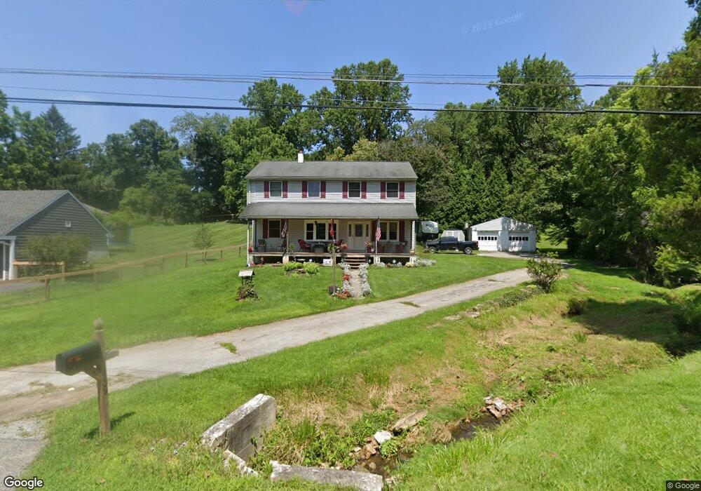
439 W Locust Ln Kennett Square, PA 19348
East Marlborough Township NeighborhoodEstimated Value: $523,683 - $673,000
4
Beds
3
Baths
1,640
Sq Ft
$361/Sq Ft
Est. Value
About This Home
This home is located at 439 W Locust Ln, Kennett Square, PA 19348 and is currently estimated at $591,921, approximately $360 per square foot. 439 W Locust Ln is a home located in Chester County with nearby schools including Hillendale Elementary School, Charles F. Patton Middle School, and Unionville High School.
Ownership History
Date
Name
Owned For
Owner Type
Purchase Details
Closed on
Oct 7, 2020
Sold by
Ross Sherri Lee and Capecci Sherri Lee
Bought by
Capecci Sherri Lee and Capecci David L
Current Estimated Value
Home Financials for this Owner
Home Financials are based on the most recent Mortgage that was taken out on this home.
Original Mortgage
$227,000
Interest Rate
2.9%
Mortgage Type
New Conventional
Purchase Details
Closed on
Mar 31, 2011
Sold by
Ross David A and Ross Sherri Lee
Bought by
Ross Sherri Lee
Create a Home Valuation Report for This Property
The Home Valuation Report is an in-depth analysis detailing your home's value as well as a comparison with similar homes in the area
Home Values in the Area
Average Home Value in this Area
Purchase History
| Date | Buyer | Sale Price | Title Company |
|---|---|---|---|
| Capecci Sherri Lee | -- | Anvil Land Transfer Company | |
| Ross Sherri Lee | -- | None Available |
Source: Public Records
Mortgage History
| Date | Status | Borrower | Loan Amount |
|---|---|---|---|
| Closed | Capecci Sherri Lee | $227,000 |
Source: Public Records
Tax History Compared to Growth
Tax History
| Year | Tax Paid | Tax Assessment Tax Assessment Total Assessment is a certain percentage of the fair market value that is determined by local assessors to be the total taxable value of land and additions on the property. | Land | Improvement |
|---|---|---|---|---|
| 2025 | $1,096 | $162,810 | $50,830 | $111,980 |
| 2024 | $1,096 | $162,810 | $50,830 | $111,980 |
| 2023 | $1,096 | $162,810 | $50,830 | $111,980 |
| 2022 | $912 | $162,810 | $50,830 | $111,980 |
| 2021 | $1,096 | $162,810 | $50,830 | $111,980 |
| 2020 | $882 | $162,810 | $50,830 | $111,980 |
| 2019 | $1,067 | $162,810 | $50,830 | $111,980 |
| 2018 | $1,067 | $162,810 | $50,830 | $111,980 |
| 2017 | $1,067 | $162,810 | $50,830 | $111,980 |
| 2016 | $646 | $162,810 | $50,830 | $111,980 |
| 2015 | $646 | $162,810 | $50,830 | $111,980 |
| 2014 | $646 | $162,810 | $50,830 | $111,980 |
Source: Public Records
Map
Nearby Homes
- 491 N Mill Rd
- 181 Penns Manor Dr
- 448 N Mill Rd
- 705 Potter Dr
- 711 Potter Dr
- 106 Penns Manor Dr
- 250 Kestrel Ct
- 117 Deer Creek Crossing
- 503 W State St
- 636 D St
- 631 Magnolia Ct
- 602 D St
- 621 Magnolia Ct
- 510 D St
- 629 W Mulberry St
- 619 W Mulberry St
- 607 W Mulberry St
- 617 Unionville Rd
- 125 W State St
- 220 E Linden St
- 437 W Locust Ln
- 441 W Locust Ln
- 456 W Locust Ln
- 458 W Locust Ln
- 532 N Mill Rd
- 534 N Mill Rd
- 516 N Mill Rd
- 521 N Mill Rd
- 538 N Mill Rd Unit LOT3
- 538 N Mill Rd Unit LOT2
- 538 N Mill Rd
- 452 W Locust Ln
- 512 N Mill Rd
- 536 N Mill Rd
- 510 N Mill Rd
- 508 N Mill Rd
- 448 W Locust Ln
- 506 N Mill Rd
- 540 N Mill Rd
- 463 Dean Dr