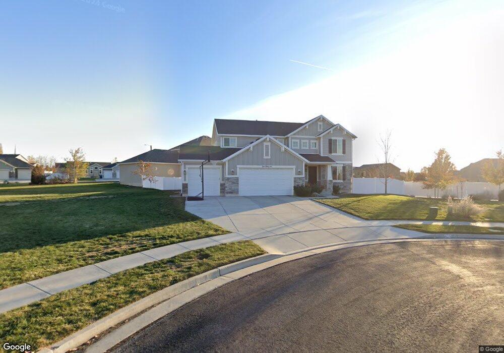
439 Wheat Ridge Cir Kaysville, UT 84037
West Kaysville NeighborhoodEstimated Value: $798,000 - $871,000
4
Beds
3
Baths
3,283
Sq Ft
$253/Sq Ft
Est. Value
About This Home
This home is located at 439 Wheat Ridge Cir, Kaysville, UT 84037 and is currently estimated at $829,365, approximately $252 per square foot. 439 Wheat Ridge Cir is a home located in Davis County with nearby schools including Columbia Elementary School, Farmington High, and Centennial Junior High School.
Ownership History
Date
Name
Owned For
Owner Type
Purchase Details
Closed on
Apr 27, 2018
Sold by
Layton Graeme D and Layton Challae M
Bought by
Challae M Layton Trustees and Layton Family Revocable Living Trust
Current Estimated Value
Purchase Details
Closed on
Jan 25, 2007
Sold by
Kaysville Development Llc
Bought by
Symphony Homes Llc
Create a Home Valuation Report for This Property
The Home Valuation Report is an in-depth analysis detailing your home's value as well as a comparison with similar homes in the area
Home Values in the Area
Average Home Value in this Area
Purchase History
| Date | Buyer | Sale Price | Title Company |
|---|---|---|---|
| Challae M Layton Trustees | -- | None Available | |
| Symphony Homes Llc | -- | Metro National Title |
Source: Public Records
Tax History Compared to Growth
Tax History
| Year | Tax Paid | Tax Assessment Tax Assessment Total Assessment is a certain percentage of the fair market value that is determined by local assessors to be the total taxable value of land and additions on the property. | Land | Improvement |
|---|---|---|---|---|
| 2025 | $3,646 | $400,950 | $209,445 | $191,505 |
| 2024 | $3,646 | $384,450 | $188,068 | $196,382 |
| 2023 | $3,674 | $686,000 | $342,529 | $343,471 |
| 2022 | $3,764 | $394,350 | $187,553 | $206,797 |
| 2021 | $3,229 | $507,000 | $215,141 | $291,859 |
| 2020 | $2,688 | $411,000 | $182,509 | $228,491 |
| 2019 | $2,791 | $419,000 | $179,732 | $239,268 |
| 2018 | $2,605 | $390,000 | $149,745 | $240,255 |
| 2016 | $2,405 | $189,256 | $68,965 | $120,291 |
| 2015 | $2,440 | $182,310 | $68,965 | $113,345 |
| 2014 | $1,476 | $112,232 | $112,232 | $0 |
| 2013 | -- | $72,858 | $72,858 | $0 |
Source: Public Records
Map
Nearby Homes
- 453 Country Mill Dr
- 382 W Parkway Dr
- 447 W June Dr
- 384 Christine Way
- 52 S Grandison Ct E Unit 83-R
- 1346 W Blackbird Ln Unit 3
- 109 S Rock Loft Ridge Dr Unit 56-R
- 159 S Rock Loft Ridge Dr Unit 59-R
- 209 N Rock Loft Ridge E Unit 32-R
- 180 S Rock Loft Ridge Dr E Unit 7-R
- 246 N Rock Loft Ridge Dr Unit 36-R
- 22 S Rock Loft Ridge Dr Unit 16-R
- 34 S Rock Loft Ridge Dr Unit 85-R
- 190 N Rock Loft Ridge Dr Unit 40-R
- 75 S Grandison Ct E Unit 69-R
- 93 S Rock Loft Ridge Dr Unit 55-R
- 167 S Grandison E Unit 74-R
- 127 S Rock Loft Ridge Dr Unit 57-R
- 28 N Rock Loft Ridge Dr Unit 46-R
- 96 S Rock Loft Ridge Dr Unit 12-R
- 439 Wheat Ridge Cir Unit 230
- 439 Wheat Ridge Cir Unit 230
- 390 W Spring Flower Cir Unit 225
- 390 W Spring Flower Cir
- 446 Wheat Ridge Cir
- 421 Wheat Ridge Cir
- 421 Wheat Ridge Cir Unit 229
- 378 W Spring Flower Cir Unit 226
- 398 W Spring Flower Cir Unit 224
- 432 Wheat Ridge Cir Unit 232
- 416 Wheat Ridge Cir
- 416 Wheat Ridge Cir Unit 233
- 407 Wheat Ridge Cir Unit 228
- 397 W Spring Flower Cir Unit 223
- 397 W Spring Flower Cir
- 441 Cornfield Cir Unit 237
- 441 Cornfield Cir
- 441 Cornfield Cir Unit 237
- 407 Wheat Ridge Cir
- 366 W Spring Flower Cir Unit 227