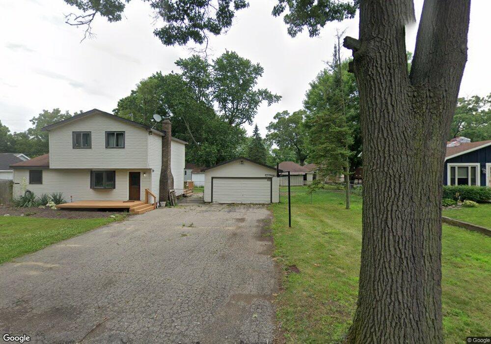
4391 Cedar Ave West Bloomfield, MI 48323
Estimated Value: $299,718 - $326,000
3
Beds
2
Baths
1,460
Sq Ft
$213/Sq Ft
Est. Value
About This Home
This home is located at 4391 Cedar Ave, West Bloomfield, MI 48323 and is currently estimated at $311,680, approximately $213 per square foot. 4391 Cedar Ave is a home located in Oakland County with nearby schools including Walled Lake Central High School, The Susan And Rabbi Harold Loss Ecc, and Brookfield Academy - West Bloomfield.
Ownership History
Date
Name
Owned For
Owner Type
Purchase Details
Closed on
Mar 26, 2010
Sold by
Mortgage Electronic Registration Systems
Bought by
Aurora Loan Services Llc
Current Estimated Value
Purchase Details
Closed on
Dec 15, 2009
Sold by
Rederstorf Timothy J and Rederstorf Joan M
Bought by
Mortgage Electronic Registration Systems
Purchase Details
Closed on
Mar 2, 1998
Sold by
Mcdowell Ruth Ann
Bought by
Rederstorf Timothy J
Home Financials for this Owner
Home Financials are based on the most recent Mortgage that was taken out on this home.
Original Mortgage
$106,250
Interest Rate
7.14%
Create a Home Valuation Report for This Property
The Home Valuation Report is an in-depth analysis detailing your home's value as well as a comparison with similar homes in the area
Home Values in the Area
Average Home Value in this Area
Purchase History
| Date | Buyer | Sale Price | Title Company |
|---|---|---|---|
| Aurora Loan Services Llc | -- | None Available | |
| Mortgage Electronic Registration Systems | $155,820 | None Available | |
| Rederstorf Timothy J | $125,000 | -- |
Source: Public Records
Mortgage History
| Date | Status | Borrower | Loan Amount |
|---|---|---|---|
| Previous Owner | Rederstorf Timothy J | $106,250 |
Source: Public Records
Tax History Compared to Growth
Tax History
| Year | Tax Paid | Tax Assessment Tax Assessment Total Assessment is a certain percentage of the fair market value that is determined by local assessors to be the total taxable value of land and additions on the property. | Land | Improvement |
|---|---|---|---|---|
| 2024 | $1,416 | $125,060 | $0 | $0 |
| 2022 | $1,335 | $103,160 | $27,050 | $76,110 |
| 2021 | $2,196 | $99,490 | $0 | $0 |
| 2020 | $1,319 | $97,620 | $27,050 | $70,570 |
| 2018 | $2,137 | $83,510 | $22,550 | $60,960 |
| 2015 | -- | $68,400 | $0 | $0 |
| 2014 | -- | $62,730 | $0 | $0 |
| 2011 | -- | $54,140 | $0 | $0 |
Source: Public Records
Map
Nearby Homes
- 4335 Crestdale Ave
- 4245 Bunker Ave
- 4442 Borland St
- 6980 Hambro St
- 6978 Colony Dr
- 4212 Greendale Ave
- 7337 Richardson Rd
- 7381 Crestmore St
- 4066 Green Lake Rd
- 0000 Langtoft
- 3991 Fieldview Ave
- 4540 Rolling Pine Ct
- 6675 Langtoft St
- 3965 Carrick Ave
- 6903 Dandison Blvd
- 7359 Woodlore Dr
- 3950 Bradmore Ave
- 6768 Buckland Ave
- 3632 Fieldview Ave
- 7065 Deerwood Trail Unit 27
- 4397 Cedar Ave
- 4382 Green Lake Rd
- 4400 Green Lake Rd
- 7021 Manderson Terrace
- 4387 Cedar Ave
- 7011 Manderson Terrace
- 4410 Green Lake Rd
- 4405 Cedar Ave
- 4396 Cedar Ave
- 4420 Green Lake Rd
- 4439 Cedar Ave
- 4383 Green Lake Rd
- 4436 Cedar Ave
- 4380 Green Lake Rd
- 4405 Green Lake Rd
- 4430 Green Lake Rd Unit Bldg-Unit
- 4430 Green Lake Rd
- 4381 Green Lake Rd
- 4395 Middledale Ave
- 4447 Cedar Ave