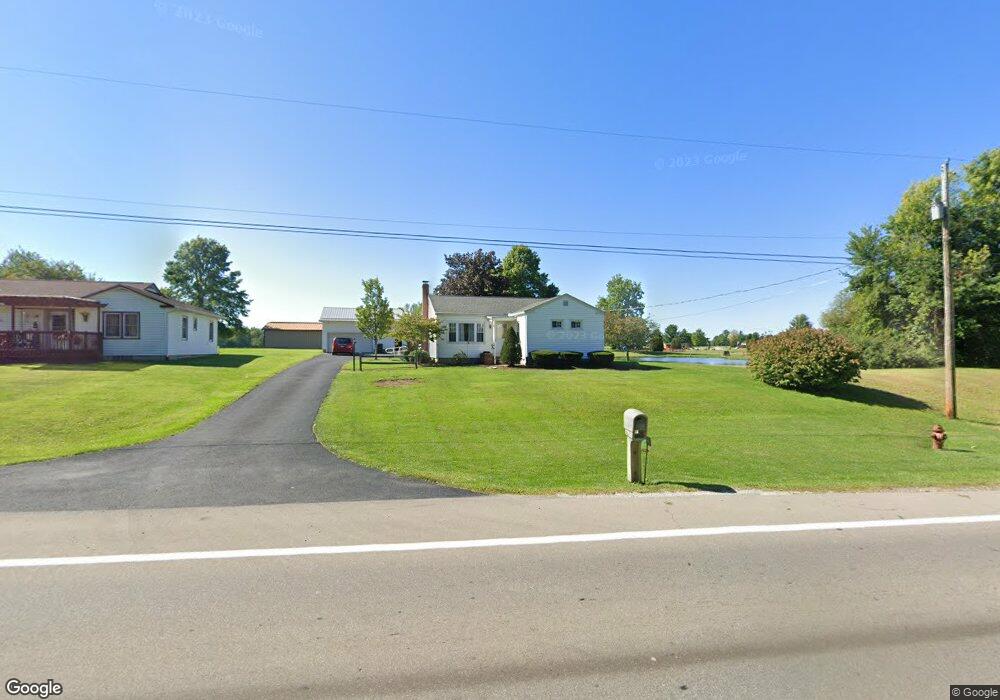
4394 State Route 95 Mount Gilead, OH 43338
Estimated Value: $144,021 - $449,000
--
Bed
--
Bath
--
Sq Ft
0.84
Acres
About This Home
This home is located at 4394 State Route 95, Mount Gilead, OH 43338 and is currently estimated at $298,255. 4394 State Route 95 is a home located in Morrow County with nearby schools including Park Avenue Elementary School, Mt Gilead Middle School, and Mt Gilead High School.
Ownership History
Date
Name
Owned For
Owner Type
Purchase Details
Closed on
Sep 26, 2023
Sold by
Baughman Harold E & L Jean Trustees
Bought by
Grauer Cody Tyler and Grauer Shalyn
Current Estimated Value
Purchase Details
Closed on
Oct 5, 2009
Sold by
Baughman Harold E and Jean L
Bought by
Baughman Harold E & L Jean Trustees
Purchase Details
Closed on
Sep 17, 2007
Bought by
Baughman Harold E Trustee and Jean Stevens Ba
Purchase Details
Closed on
Dec 29, 2000
Sold by
Baughman Harold E And
Bought by
Baughman Harold E & Ruth L Trustees
Purchase Details
Closed on
Apr 3, 1990
Bought by
Baughman Harold E And
Create a Home Valuation Report for This Property
The Home Valuation Report is an in-depth analysis detailing your home's value as well as a comparison with similar homes in the area
Home Values in the Area
Average Home Value in this Area
Purchase History
| Date | Buyer | Sale Price | Title Company |
|---|---|---|---|
| Grauer Cody Tyler | $220,000 | -- | |
| Baughman Harold E & L Jean Trustees | -- | -- | |
| Baughman Harold E | -- | -- | |
| Baughman Harold E Trustee | -- | -- | |
| Baughman Harold E & Ruth L Trustees | -- | -- | |
| Baughman Harold E And | $3,400 | -- |
Source: Public Records
Tax History Compared to Growth
Tax History
| Year | Tax Paid | Tax Assessment Tax Assessment Total Assessment is a certain percentage of the fair market value that is determined by local assessors to be the total taxable value of land and additions on the property. | Land | Improvement |
|---|---|---|---|---|
| 2024 | $597 | $13,450 | $7,740 | $5,710 |
| 2023 | $597 | $13,450 | $7,740 | $5,710 |
| 2022 | $438 | $8,620 | $4,310 | $4,310 |
| 2021 | $418 | $8,620 | $4,310 | $4,310 |
| 2020 | $418 | $8,620 | $4,310 | $4,310 |
| 2019 | $360 | $7,220 | $3,610 | $3,610 |
| 2018 | $360 | $7,220 | $3,610 | $3,610 |
| 2017 | $334 | $7,220 | $3,610 | $3,610 |
| 2016 | $301 | $6,450 | $3,120 | $3,330 |
| 2015 | $284 | $6,450 | $3,120 | $3,330 |
| 2014 | $289 | $6,450 | $3,120 | $3,330 |
| 2013 | $289 | $6,790 | $3,290 | $3,500 |
Source: Public Records
Map
Nearby Homes
- 5280 Township Road 103
- 4350 Township Road 110
- 0 Township Road 110 Unit 6131011
- 5098 County Road 237
- 250 S Main St
- 69 N Cherry St
- 186 Iberia St
- 0 Tamarack Unit 223034150
- 0 Iberia St
- 251 Lincoln Ave
- 236 W High St
- 264 W High St
- 357 N Delaware St
- 5171 U S 42
- 473 N Delaware St
- 362 W High St
- 0 Lee St
- 574 Buckeye Ln
- 4449 County Road 114
- 4681 County Road 101
- 4394 State Route 95
- 4408 State Route 95
- 4418 State Route 95
- 4409 Ohio 95
- 4409 State Route 95
- 4417 State Route 95
- 661 E High St
- 4433 State Route 95
- 4433 Ohio 95
- 4465 State Route 95
- 4473 State Route 95
- 901 E High St
- 4119 Ohio 95
- 4562 State Route 95
- 4562 Ohio 95
- 100 Fairway Ln
- 120 Fairway Ln
- 701 E High St
- 130 Fairway Ln
- 140 Fairway Ln