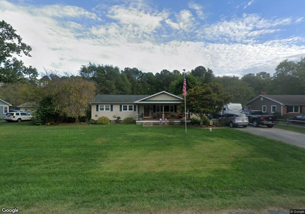
43953 Lanedon Dr Leonardtown, MD 20650
Estimated Value: $310,000 - $401,000
Studio
2
Baths
1,680
Sq Ft
$211/Sq Ft
Est. Value
About This Home
This home is located at 43953 Lanedon Dr, Leonardtown, MD 20650 and is currently estimated at $353,773, approximately $210 per square foot. 43953 Lanedon Dr is a home located in St. Mary's County with nearby schools including Piney Point Elementary School, Leonardtown Middle School, and Leonardtown High School.
Ownership History
Date
Name
Owned For
Owner Type
Purchase Details
Closed on
Jul 20, 1999
Sold by
Delaney Carl T and Delaney Twyla K
Bought by
Duval Mark M and Duval Miriam A
Current Estimated Value
Purchase Details
Closed on
Jul 27, 1994
Sold by
Rm Dyer
Bought by
Delaney Carl T
Home Financials for this Owner
Home Financials are based on the most recent Mortgage that was taken out on this home.
Original Mortgage
$99,950
Interest Rate
8.25%
Create a Home Valuation Report for This Property
The Home Valuation Report is an in-depth analysis detailing your home's value as well as a comparison with similar homes in the area
Purchase History
| Date | Buyer | Sale Price | Title Company |
|---|---|---|---|
| Duval Mark M | $117,000 | -- | |
| Delaney Carl T | $98,000 | -- |
Source: Public Records
Mortgage History
| Date | Status | Borrower | Loan Amount |
|---|---|---|---|
| Previous Owner | Delaney Carl T | $99,950 | |
| Closed | Duval Mark M | -- |
Source: Public Records
Tax History
| Year | Tax Paid | Tax Assessment Tax Assessment Total Assessment is a certain percentage of the fair market value that is determined by local assessors to be the total taxable value of land and additions on the property. | Land | Improvement |
|---|---|---|---|---|
| 2025 | $2,796 | $249,000 | $111,800 | $137,200 |
| 2024 | $2,694 | $239,533 | $0 | $0 |
| 2023 | $2,592 | $230,067 | $0 | $0 |
| 2022 | $2,490 | $220,600 | $117,800 | $102,800 |
| 2021 | $2,431 | $215,200 | $0 | $0 |
| 2020 | $2,372 | $209,800 | $0 | $0 |
| 2019 | $2,313 | $204,400 | $112,300 | $92,100 |
| 2018 | $2,311 | $204,400 | $112,300 | $92,100 |
| 2017 | $2,249 | $204,400 | $0 | $0 |
| 2016 | -- | $206,400 | $0 | $0 |
| 2015 | -- | $206,333 | $0 | $0 |
| 2014 | $1,847 | $206,267 | $0 | $0 |
Source: Public Records
Map
Nearby Homes
- 19700 Mulberry Fields Rd
- 44731 Blake Creek Rd
- 19921 Tower Hill Rd
- 20045 Tower Hill Rd
- 44545 Brewer Ln
- 44798 Medleys Neck Rd
- 43488 Medleys Neck Rd
- 18832 Piney Point Rd
- 45252 Happyland Rd
- 0 Piney Point Rd
- 43641 Redmond Rd
- 44939 Shore Dr
- 42520 Riverwinds Dr
- 17615 Driftwood Dr
- 43552 Bayberry Ct
- 0 Saint Georges Park Rd
- 17863 2nd St
- 0 Third St
- 17860 3rd St
- 0 Flat Iron Rd
- 43945 Lanedon Dr
- 43963 Lanedon Dr
- 43939 Lanedon Dr
- 43956 Lanedon Dr
- 43946 Lanedon Dr
- 43938 Lanedon Dr
- 43935 Lanedon Dr
- 43968 Lanedon Dr
- 43934 Lanedon Dr
- 43945 Main Way Rd
- 43927 Lanedon Dr
- 43935 Main Way Rd
- 43924 Lanedon Dr
- 43911 Lanedon Dr
- 44047 Blake Creek Rd
- 43918 Lanedon Dr
- 44047 Blake Creek Rd
- 43988 Blake Creek Rd
- 43925 Main Way Rd
- 43950 Blake Creek Rd
Your Personal Tour Guide
Ask me questions while you tour the home.