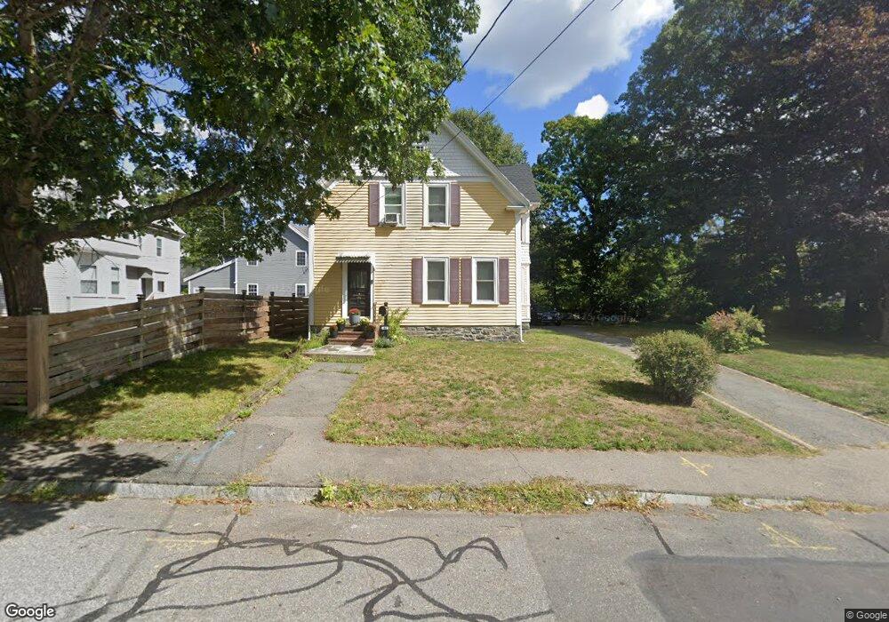
44 Clinton St Unit Single Fam Taunton, MA 02780
Estimated Value: $493,000 - $552,000
3
Beds
1
Bath
1,910
Sq Ft
$274/Sq Ft
Est. Value
About This Home
This home is located at 44 Clinton St Unit Single Fam, Taunton, MA 02780 and is currently estimated at $522,643, approximately $273 per square foot. 44 Clinton St Unit Single Fam is a home located in Bristol County with nearby schools including Mulcahey Elementary School, Taunton High School, and John F. Parker Middle School.
Ownership History
Date
Name
Owned For
Owner Type
Purchase Details
Closed on
Oct 2, 2020
Sold by
Walsh Kimberty H
Bought by
Gorsuch Jason D and Gorsuch Kimberty H
Current Estimated Value
Purchase Details
Closed on
Feb 13, 2017
Sold by
Tooker Wiggs R and Tooker Patricia L
Bought by
Gorsuch Jason D and Walsh Kimberly H
Home Financials for this Owner
Home Financials are based on the most recent Mortgage that was taken out on this home.
Original Mortgage
$237,553
Interest Rate
4.32%
Mortgage Type
New Conventional
Purchase Details
Closed on
Nov 23, 2004
Sold by
Matteson-Kane Maureen
Bought by
Wiggs R Lee and Tooker Patricia Lois
Home Financials for this Owner
Home Financials are based on the most recent Mortgage that was taken out on this home.
Original Mortgage
$197,100
Interest Rate
5.8%
Mortgage Type
Purchase Money Mortgage
Create a Home Valuation Report for This Property
The Home Valuation Report is an in-depth analysis detailing your home's value as well as a comparison with similar homes in the area
Home Values in the Area
Average Home Value in this Area
Purchase History
| Date | Buyer | Sale Price | Title Company |
|---|---|---|---|
| Gorsuch Jason D | -- | None Available | |
| Gorsuch Jason D | $244,900 | -- | |
| Wiggs R Lee | $219,000 | -- |
Source: Public Records
Mortgage History
| Date | Status | Borrower | Loan Amount |
|---|---|---|---|
| Previous Owner | Gorsuch Jason D | $237,553 | |
| Previous Owner | Wiggs R Lee | $197,100 |
Source: Public Records
Tax History Compared to Growth
Tax History
| Year | Tax Paid | Tax Assessment Tax Assessment Total Assessment is a certain percentage of the fair market value that is determined by local assessors to be the total taxable value of land and additions on the property. | Land | Improvement |
|---|---|---|---|---|
| 2025 | $5,503 | $503,000 | $118,900 | $384,100 |
| 2024 | $4,968 | $444,000 | $118,900 | $325,100 |
| 2023 | $4,873 | $404,400 | $118,900 | $285,500 |
| 2022 | $4,696 | $356,300 | $99,100 | $257,200 |
| 2021 | $4,530 | $319,000 | $90,100 | $228,900 |
| 2020 | $4,347 | $292,500 | $90,100 | $202,400 |
| 2019 | $4,164 | $264,200 | $90,100 | $174,100 |
| 2018 | $4,111 | $261,500 | $91,000 | $170,500 |
| 2017 | $2,873 | $182,900 | $86,300 | $96,600 |
| 2016 | $2,785 | $177,600 | $83,800 | $93,800 |
| 2015 | $2,682 | $178,700 | $81,500 | $97,200 |
| 2014 | $2,633 | $180,200 | $81,500 | $98,700 |
Source: Public Records
Map
Nearby Homes
- 16 Clinton St
- 22 Everett St
- 72 Barnum St
- 98 Winthrop St
- 132 Winthrop St
- 252 Somerset Ave
- 46 Harrison St Unit 4
- 4 Parkin Ct
- 56 Silver St
- 19 Mason St
- 39 Myrtle St
- 215 High St Unit 21
- 215 High St Unit 20
- 450 Somerset Ave Unit 2-7
- 450 Somerset Ave Unit 6-6
- 193 Winthrop St
- 48 Oak St
- 48 Taunton Green
- 0, M64 L51 Knapp St
- 0 M64 L39 Knapp St
- 44 Clinton St
- 44 Clinton St
- 44 Clinton St
- 44 Clinton St
- 44 Clinton St
- 48 Clinton St
- 48 Clinton St Unit 1
- 42 Clinton St
- 42 Clinton St Unit 42 Clinton St. 2nd Flr.
- 42 Clinton St Unit 42 Clinton St. 1st f
- 42 Clinton St Unit 1
- 45 Clinton St
- 45 Clinton St Unit 1
- 60 Clinton St
- 60 Clinton St Unit 1
- 60 Clinton St Unit 60
- 54 White St
- 47 Clinton St
- 43 Clinton St
- 43 Clinton St Unit 2