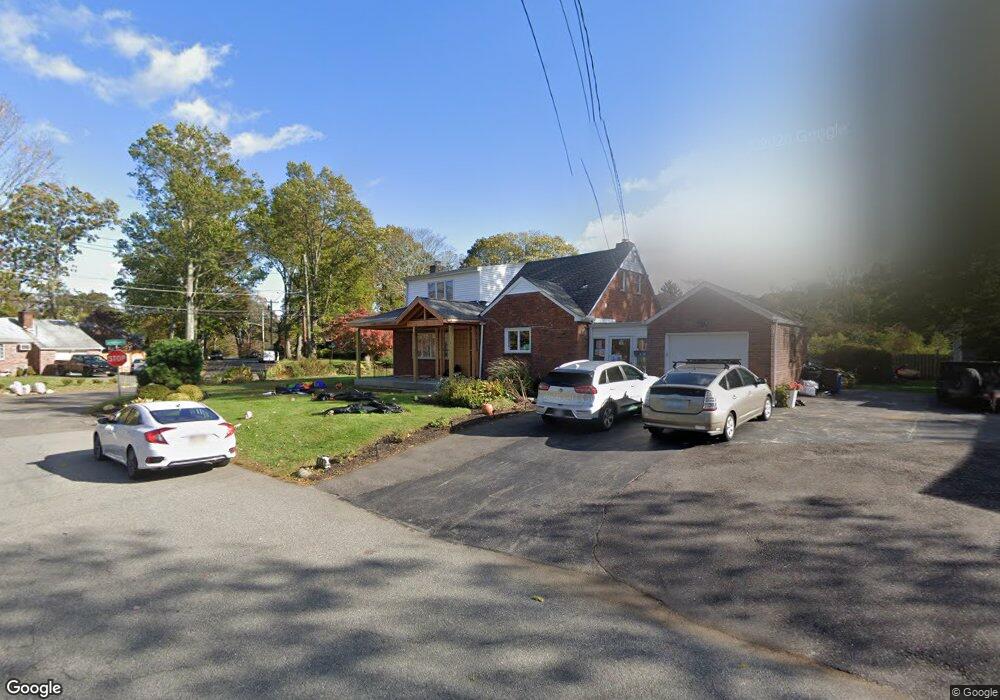
44 Monaton Dr Huntington Station, NY 11746
Estimated Value: $685,000 - $799,280
5
Beds
2
Baths
--
Sq Ft
0.31
Acres
About This Home
This home is located at 44 Monaton Dr, Huntington Station, NY 11746 and is currently estimated at $758,320. 44 Monaton Dr is a home located in Suffolk County with nearby schools including Washington School, Woodhull Intermediate School, and J Taylor Finley Middle School.
Ownership History
Date
Name
Owned For
Owner Type
Purchase Details
Closed on
Dec 28, 2016
Sold by
Fischer Diana Sue and The Carol Joan Fischer Living
Bought by
Popalzai Khatra and Pipia Khatra
Current Estimated Value
Home Financials for this Owner
Home Financials are based on the most recent Mortgage that was taken out on this home.
Original Mortgage
$315,000
Outstanding Balance
$260,912
Interest Rate
4.3%
Mortgage Type
New Conventional
Estimated Equity
$497,408
Purchase Details
Closed on
Oct 27, 2004
Create a Home Valuation Report for This Property
The Home Valuation Report is an in-depth analysis detailing your home's value as well as a comparison with similar homes in the area
Home Values in the Area
Average Home Value in this Area
Purchase History
| Date | Buyer | Sale Price | Title Company |
|---|---|---|---|
| Popalzai Khatra | $350,000 | None Available | |
| -- | -- | -- |
Source: Public Records
Mortgage History
| Date | Status | Borrower | Loan Amount |
|---|---|---|---|
| Open | Popalzai Khatra | $315,000 |
Source: Public Records
Tax History Compared to Growth
Tax History
| Year | Tax Paid | Tax Assessment Tax Assessment Total Assessment is a certain percentage of the fair market value that is determined by local assessors to be the total taxable value of land and additions on the property. | Land | Improvement |
|---|---|---|---|---|
| 2024 | $13,390 | $3,525 | $300 | $3,225 |
| 2023 | $6,695 | $3,525 | $300 | $3,225 |
| 2022 | $11,212 | $3,525 | $300 | $3,225 |
| 2021 | $11,110 | $2,950 | $300 | $2,650 |
| 2020 | $10,989 | $2,950 | $300 | $2,650 |
| 2019 | $21,977 | $0 | $0 | $0 |
| 2018 | $10,758 | $2,950 | $300 | $2,650 |
| 2017 | $10,758 | $2,950 | $300 | $2,650 |
| 2016 | $8,945 | $2,950 | $300 | $2,650 |
| 2015 | -- | $2,950 | $300 | $2,650 |
| 2014 | -- | $2,950 | $300 | $2,650 |
Source: Public Records
Map
Nearby Homes
- 12 Foxdale Ct
- 39 Lewis Ct
- 217 Broadway
- 142 Crooked Hill Rd
- 22 Meadowood Ct
- 2202 Townhome Way
- 78 Hayloft Ct
- 71 Biltmore Cir
- 148 Lenox Rd
- 634 Park Ave
- 1 Ashland Dr
- 11 Spring Ct
- 62 Lowndes Ave
- 2 Spring Ct
- 6 Albermarle Ave
- 35 Turtle Cove Ln
- 26 Townhouse Rd S Unit 26
- 813 Park Ave
- 200 Lowndes Ave Unit A
- 280 Lowndes Ave Unit 208