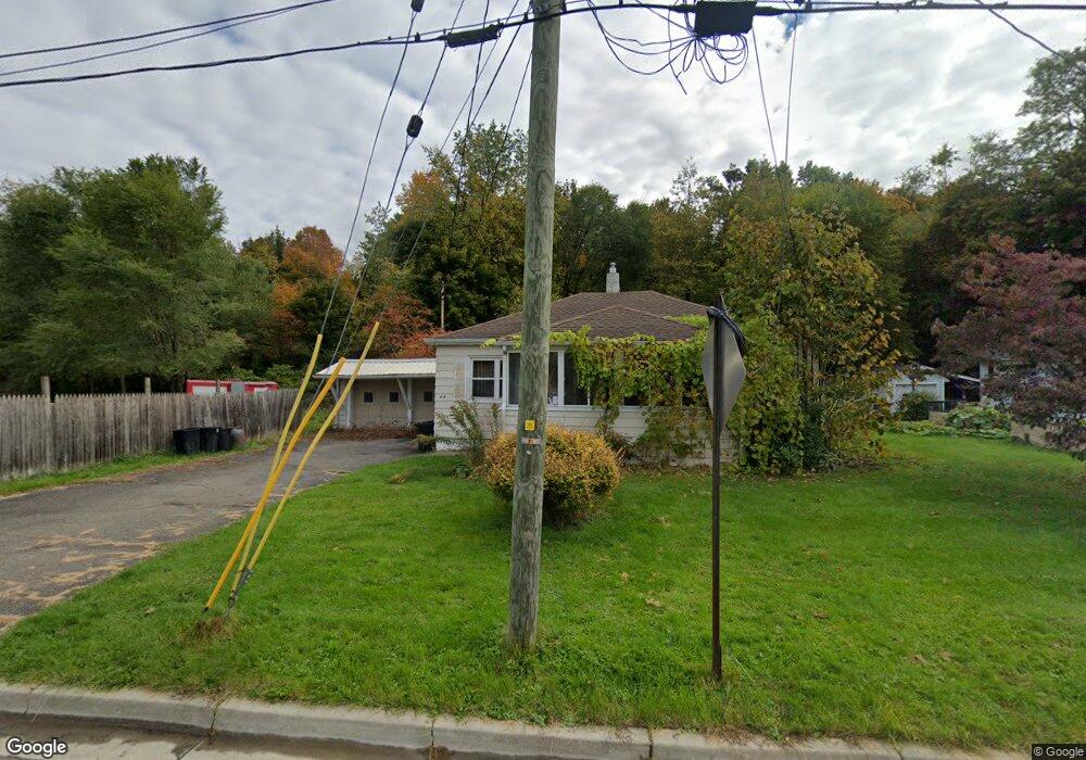
44 N Brookside Ave Endicott, NY 13760
Estimated Value: $121,000 - $151,000
2
Beds
1
Bath
952
Sq Ft
$145/Sq Ft
Est. Value
About This Home
This home is located at 44 N Brookside Ave, Endicott, NY 13760 and is currently estimated at $137,700, approximately $144 per square foot. 44 N Brookside Ave is a home located in Broome County with nearby schools including Maine-Endwell Senior High School, All Saints School, and All Saints.
Ownership History
Date
Name
Owned For
Owner Type
Purchase Details
Closed on
Dec 13, 2012
Sold by
Flint Wayne and Flin Anna N
Bought by
Mancini Anthony and Mancini Patricia
Current Estimated Value
Purchase Details
Closed on
May 29, 2008
Sold by
Secretary Of Housing & Urban Development
Bought by
Flint Wayne
Purchase Details
Closed on
Jan 29, 2008
Sold by
Katon (
Bought by
Secretary Of Housing And Urban Development
Purchase Details
Closed on
Jul 21, 1996
Sold by
Carter Jennie
Bought by
Katon Harry T and Katon Dorothy M
Create a Home Valuation Report for This Property
The Home Valuation Report is an in-depth analysis detailing your home's value as well as a comparison with similar homes in the area
Home Values in the Area
Average Home Value in this Area
Purchase History
| Date | Buyer | Sale Price | Title Company |
|---|---|---|---|
| Mancini Anthony | $44,000 | None Available | |
| Flint Wayne | $46,322 | Lachman & Gorton | |
| Secretary Of Housing And Urban Development | $64,375 | Steven Baum | |
| Katon Harry T | $51,200 | -- |
Source: Public Records
Tax History
| Year | Tax Paid | Tax Assessment Tax Assessment Total Assessment is a certain percentage of the fair market value that is determined by local assessors to be the total taxable value of land and additions on the property. | Land | Improvement |
|---|---|---|---|---|
| 2024 | $2,638 | $2,500 | $375 | $2,125 |
| 2023 | $2,602 | $2,500 | $375 | $2,125 |
| 2022 | $2,634 | $2,500 | $375 | $2,125 |
| 2021 | $2,602 | $2,500 | $375 | $2,125 |
| 2020 | $4,660 | $2,500 | $375 | $2,125 |
| 2019 | $0 | $2,500 | $375 | $2,125 |
| 2018 | $2,764 | $2,500 | $375 | $2,125 |
| 2017 | $2,467 | $2,500 | $375 | $2,125 |
| 2016 | $4,213 | $2,500 | $375 | $2,125 |
| 2015 | -- | $2,500 | $375 | $2,125 |
| 2014 | -- | $2,500 | $375 | $2,125 |
Source: Public Records
Map
Nearby Homes
- 3517 Mary St
- 30 N Avenue B
- 12 Paynter Ave
- 315 Norton Ave
- 52 Lee Ave
- 3013 Robins St
- 3102 Buckingham Rd
- 3617 Lott St
- 515 Lowell Dr
- 2829 Country Club Rd
- 2823 Yale St
- 111 Moore Ave
- 502 Winston Dr
- 3741 River Rd
- 228 Hastings Ave
- 222 Harding Ave
- 2400 North St
- 1928 Pearl St
- 3819 Country Club Rd
- 288 Lewis St
- 42 N Brookside Ave
- 3503 Mary St
- 38 N Brookside Ave
- 45 N Brookside Ave
- 47 N Brookside Ave
- 36 N Brookside Ave
- 3312 Wayne St
- 3309 Wayne St
- 3505 Mary St
- 3502 Watson Blvd
- 3500 Watson Blvd
- 3310 Wayne St
- 34 N Brookside Ave
- 15 Virginia Ave
- 3307 Wayne St
- 3308 Wayne St
- 35 N Brookside Ave
- 17 Virginia Ave
- 3509 Mary St
- 32 N Brookside Ave
Your Personal Tour Guide
Ask me questions while you tour the home.