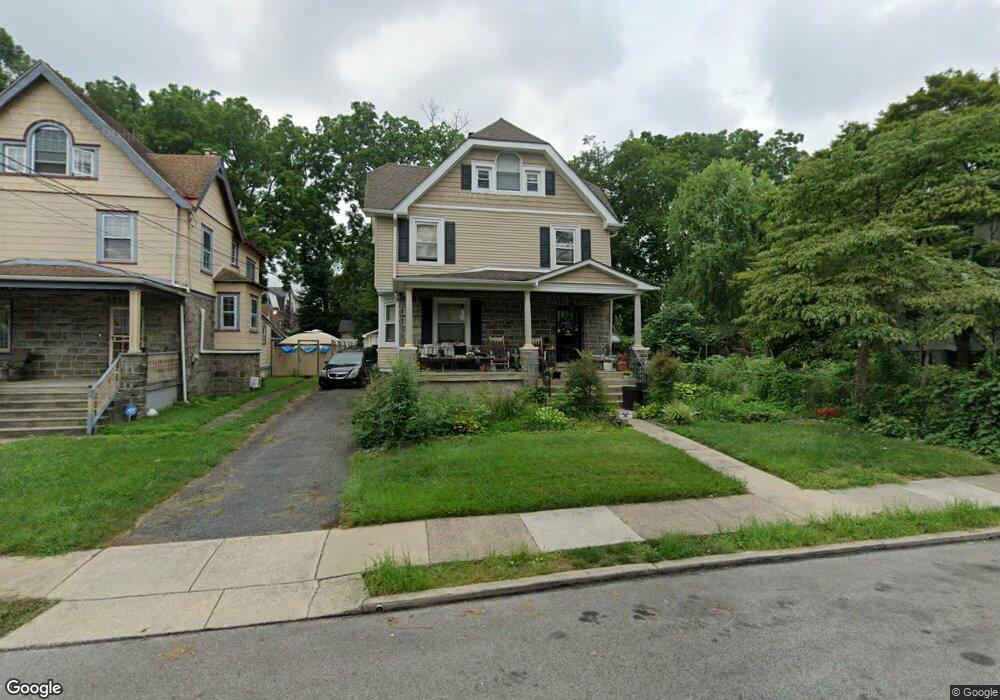
44 N Maple Ave Lansdowne, PA 19050
Estimated Value: $291,000 - $343,000
5
Beds
2
Baths
2,398
Sq Ft
$135/Sq Ft
Est. Value
About This Home
This home is located at 44 N Maple Ave, Lansdowne, PA 19050 and is currently estimated at $323,394, approximately $134 per square foot. 44 N Maple Ave is a home located in Delaware County with nearby schools including East Lansdowne Elementary School, Penn Wood Middle School, and Penn Wood High School - Cypress Street Campus.
Ownership History
Date
Name
Owned For
Owner Type
Purchase Details
Closed on
Jul 24, 1997
Sold by
Cripps Ferdinand A and Cripps Edna M
Bought by
Williams Minnie A and Williams Debora G
Current Estimated Value
Home Financials for this Owner
Home Financials are based on the most recent Mortgage that was taken out on this home.
Original Mortgage
$66,000
Outstanding Balance
$9,500
Interest Rate
7.55%
Estimated Equity
$313,894
Create a Home Valuation Report for This Property
The Home Valuation Report is an in-depth analysis detailing your home's value as well as a comparison with similar homes in the area
Home Values in the Area
Average Home Value in this Area
Purchase History
| Date | Buyer | Sale Price | Title Company |
|---|---|---|---|
| Williams Minnie A | $106,000 | -- |
Source: Public Records
Mortgage History
| Date | Status | Borrower | Loan Amount |
|---|---|---|---|
| Open | Williams Minnie A | $66,000 |
Source: Public Records
Tax History Compared to Growth
Tax History
| Year | Tax Paid | Tax Assessment Tax Assessment Total Assessment is a certain percentage of the fair market value that is determined by local assessors to be the total taxable value of land and additions on the property. | Land | Improvement |
|---|---|---|---|---|
| 2025 | $7,076 | $171,870 | $37,340 | $134,530 |
| 2024 | $7,076 | $171,870 | $37,340 | $134,530 |
| 2023 | $6,746 | $171,870 | $37,340 | $134,530 |
| 2022 | $6,614 | $171,870 | $37,340 | $134,530 |
| 2021 | $9,932 | $171,870 | $37,340 | $134,530 |
| 2020 | $5,696 | $86,850 | $24,440 | $62,410 |
| 2019 | $5,600 | $86,850 | $24,440 | $62,410 |
| 2018 | $5,504 | $86,850 | $0 | $0 |
| 2017 | $5,383 | $86,850 | $0 | $0 |
| 2016 | $477 | $86,850 | $0 | $0 |
| 2015 | $486 | $86,850 | $0 | $0 |
| 2014 | $486 | $86,850 | $0 | $0 |
Source: Public Records
Map
Nearby Homes
- 32 N Wycombe Ave
- 75 E Stewart Ave
- 37 E Stratford Ave
- 46 S Maple Ave
- 230 Wynnewood Ave
- 226 E Greenwood Ave
- 209 E Greenwood Ave
- 49 Elberon Ave
- 315 E Essex Ave
- 317 E Essex Ave
- 319 E Essex Ave
- 178 N Union Ave
- 29 W Stratford Ave
- 608 Pembroke Ave
- 164 Woodland Ave
- 38 W Stratford Ave
- 192 Fairview Ave
- 408 S Union Ave
- 144 Fairview Ave
- 88 E Essex Ave
- 40 N Maple Ave
- 52 N Maple Ave
- 36 N Maple Ave
- 86 E Stratford Ave
- 93 E La Crosse Ave
- 32 N Maple Ave
- 91 E La Crosse Ave
- 41 N Maple Ave
- 45 N Maple Ave
- 37 N Maple Ave
- 112 E Stratford Ave
- 89 E La Crosse Ave
- 74 E Stratford Ave
- 33 N Maple Ave
- 87 E La Crosse Ave
- 107 E Stratford Ave
- 99 E Stratford Ave
- 93 E Stratford Ave
- 68 E Stratford Ave
- 28 N Maple Ave