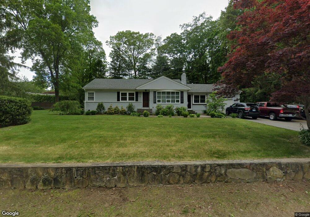
44 Pole Bridge Rd North Scituate, RI 02857
Estimated Value: $495,693 - $555,000
3
Beds
2
Baths
2,187
Sq Ft
$237/Sq Ft
Est. Value
About This Home
This home is located at 44 Pole Bridge Rd, North Scituate, RI 02857 and is currently estimated at $518,673, approximately $237 per square foot. 44 Pole Bridge Rd is a home located in Providence County with nearby schools including North Scituate School, Scituate Middle School, and Scituate High School.
Ownership History
Date
Name
Owned For
Owner Type
Purchase Details
Closed on
Nov 4, 2003
Sold by
Goyette Michael D and Goyette Audra M
Bought by
Piccolo Brian A and Piccolo Stephanie A
Current Estimated Value
Purchase Details
Closed on
Oct 27, 2000
Sold by
Rocchio Robert and Rocchio Lisa M
Bought by
Goyette Michael D and Carnes Audra M
Purchase Details
Closed on
Dec 22, 1995
Sold by
Davies Jacqueline P
Bought by
Rocchio Robert and Rocchio Lisa
Create a Home Valuation Report for This Property
The Home Valuation Report is an in-depth analysis detailing your home's value as well as a comparison with similar homes in the area
Home Values in the Area
Average Home Value in this Area
Purchase History
| Date | Buyer | Sale Price | Title Company |
|---|---|---|---|
| Piccolo Brian A | $265,000 | -- | |
| Goyette Michael D | $150,000 | -- | |
| Rocchio Robert | $120,000 | -- |
Source: Public Records
Mortgage History
| Date | Status | Borrower | Loan Amount |
|---|---|---|---|
| Open | Rocchio Robert | $24,800 | |
| Open | Rocchio Robert | $209,400 |
Source: Public Records
Tax History Compared to Growth
Tax History
| Year | Tax Paid | Tax Assessment Tax Assessment Total Assessment is a certain percentage of the fair market value that is determined by local assessors to be the total taxable value of land and additions on the property. | Land | Improvement |
|---|---|---|---|---|
| 2025 | $5,606 | $323,500 | $111,400 | $212,100 |
| 2024 | $5,606 | $323,500 | $111,400 | $212,100 |
| 2023 | $5,422 | $323,500 | $111,400 | $212,100 |
| 2022 | $5,299 | $323,500 | $111,400 | $212,100 |
| 2021 | $5,011 | $268,100 | $92,400 | $175,700 |
| 2020 | $4,898 | $268,100 | $92,400 | $175,700 |
| 2019 | $4,796 | $268,100 | $92,400 | $175,700 |
| 2018 | $4,566 | $235,500 | $79,400 | $156,100 |
| 2017 | $4,432 | $235,500 | $79,400 | $156,100 |
| 2016 | $4,248 | $235,500 | $79,400 | $156,100 |
| 2015 | $3,997 | $208,600 | $72,600 | $136,000 |
| 2014 | $3,959 | $208,600 | $72,600 | $136,000 |
Source: Public Records
Map
Nearby Homes
- 17 Country Side Ln
- 22 Oakridge Rd
- 111 Peeptoad Rd
- 12 Tamarac Dr Unit B
- 6 Tamarac Dr Unit C
- 110 Hopkins Ave
- 15 Chiswick Rd
- 125 Smith Ave Unit 4C
- 125 Smith Ave Unit 8F
- 125 Smith Ave Unit 1B
- 125 Smith Ave Unit 5C
- 42 Hopkins Ave
- 111 Smith Ave Unit 7
- 62 Orchard Ave
- 66 Orchard Ave
- 68 Orchard Ave
- 40 Hartford Ave
- 56 Pine Ledge Rd
- 112 Winsor Ave
- 75 Smith Ave
- 50 Pole Bridge Rd
- 34 Pole Bridge Rd
- 37 Pole Bridge Rd
- 28 Country Side Ln
- 47 Pole Bridge Rd
- 24 Country Side Ln
- 33 Pole Bridge Rd
- 7 Alfalfa Dr
- 56 Pole Bridge Rd
- 29 Country Side Ln
- 4 Alfalfa Dr
- 16 Country Side Ln
- 84 Countryside Dr
- 23 Country Side Ln
- 33 Country Side Ln
- 8 Alfalfa Dr
- 29 Pole Bridge Rd
- 18 Alfalfa Dr
- 6 Country Side Ln
- 12 S Woodland Rd