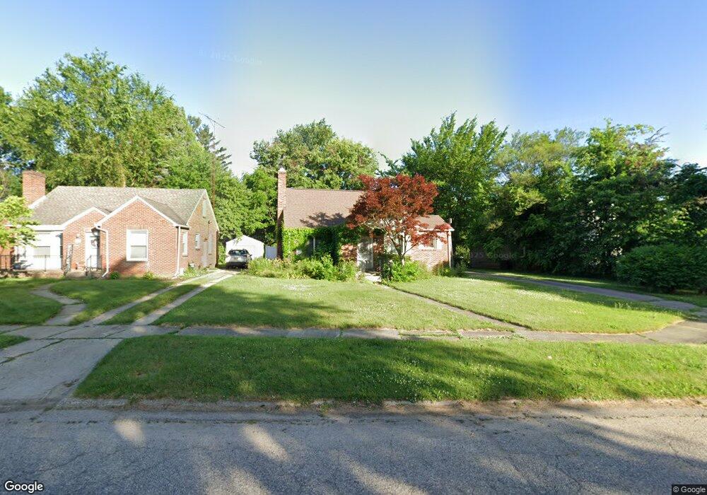
440 Commonwealth Ave Flint, MI 48503
College Cultural Neighborhood NeighborhoodEstimated Value: $108,000 - $124,389
3
Beds
1
Bath
1,193
Sq Ft
$98/Sq Ft
Est. Value
About This Home
This home is located at 440 Commonwealth Ave, Flint, MI 48503 and is currently estimated at $116,847, approximately $97 per square foot. 440 Commonwealth Ave is a home located in Genesee County with nearby schools including Pierce Elementary School, Flint Cultural Center Academy, and WAY Academy of Flint.
Ownership History
Date
Name
Owned For
Owner Type
Purchase Details
Closed on
Mar 20, 2017
Sold by
Hutchison Peter M
Bought by
Hutchison Peter M and Hutchison Thomas Murray
Current Estimated Value
Purchase Details
Closed on
Mar 31, 2011
Sold by
Bellows Christina L
Bought by
Hutchison Pete M
Purchase Details
Closed on
Dec 5, 2003
Sold by
Lasalle Bank Na
Bought by
Bellows Christina L
Purchase Details
Closed on
Dec 11, 2002
Sold by
Browning Judy A
Bought by
Lasalle Bank Na
Purchase Details
Closed on
Dec 8, 1999
Sold by
Browning J A
Bought by
D & N Bank Fsb
Create a Home Valuation Report for This Property
The Home Valuation Report is an in-depth analysis detailing your home's value as well as a comparison with similar homes in the area
Home Values in the Area
Average Home Value in this Area
Purchase History
| Date | Buyer | Sale Price | Title Company |
|---|---|---|---|
| Hutchison Peter M | -- | None Available | |
| Hutchison Pete M | $26,000 | Sargents Title Company | |
| Bellows Christina L | $77,000 | First American Title | |
| Lasalle Bank Na | $82,431 | -- | |
| D & N Bank Fsb | $69,300 | -- |
Source: Public Records
Tax History
| Year | Tax Paid | Tax Assessment Tax Assessment Total Assessment is a certain percentage of the fair market value that is determined by local assessors to be the total taxable value of land and additions on the property. | Land | Improvement |
|---|---|---|---|---|
| 2025 | $1,227 | $59,800 | $0 | $0 |
| 2024 | $1,103 | $60,400 | $0 | $0 |
| 2023 | $1,079 | $49,300 | $0 | $0 |
| 2022 | $0 | $42,000 | $0 | $0 |
| 2021 | $1,127 | $42,300 | $0 | $0 |
| 2020 | $1,008 | $36,700 | $0 | $0 |
| 2019 | $977 | $25,700 | $0 | $0 |
| 2018 | $995 | $24,600 | $0 | $0 |
| 2017 | $965 | $0 | $0 | $0 |
| 2016 | $958 | $0 | $0 | $0 |
| 2015 | -- | $0 | $0 | $0 |
| 2014 | -- | $0 | $0 | $0 |
| 2012 | -- | $19,700 | $0 | $0 |
Source: Public Records
Map
Nearby Homes
- 301 Chandler St
- 605 S Lynch St
- 2119 Mountain Ave
- 434 Chalmers St
- 2013 E Court St
- 2605 Nebraska Ave
- 2301 Missouri Ave
- 1216 Minnesota Ave
- 1318 Cronk Ave
- 1114 W Vernon Dr
- 2415 Pennsylvania Ave
- 1501 Arlington Ave
- 2610 Pennsylvania Ave
- 2613 Pennsylvania Ave
- 1210 Blanchard Ave
- 1622 Arlington Ave
- 1609 Ohio Ave
- 1510 S Franklin Ave
- 2601 Illinois Ave
- 1540 Illinois Ave
- 450 Commonwealth Ave
- 408 Hastings St
- 2024 Glendale Ave
- 2028 Glendale Ave
- 2020 Glendale Ave
- 462 Commonwealth Ave
- 456 Commonwealth Ave
- 425 Commonwealth Ave
- 2016 Glendale Ave
- 2101 E 2nd St
- 411 Commonwealth Ave
- 468 Commonwealth Ave
- 2019 E 2nd St
- 2012 Glendale Ave
- 2033 Glendale Ave
- 2113 E 2nd St
- 2023 Glendale Ave
- 401 Commonwealth Ave
- 420 S Vernon Ave
- 426 S Vernon Ave
Your Personal Tour Guide
Ask me questions while you tour the home.