440 N Queen St Littlestown, PA 17340
Estimated payment $2,182/month
About This Lot
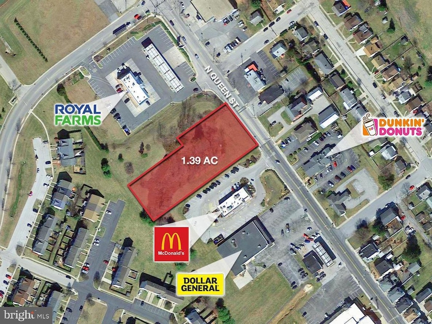
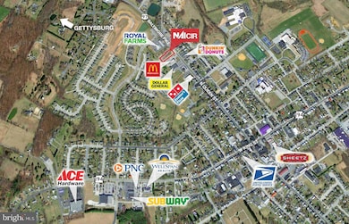
NAI CIR is offering for sale 1.39 acres zoned C-3 Highway-Oriented Commercial District
in Littlestown, PA. The land sits in between Royal Farms and McDonald's and across
from Dunkin Donuts. Zoning allows for such uses as restaurants, professional offices, and
retail amongst many other uses. This South Central PA region land features high traffic
from local, commuters, and tourists alike.
Listing Agent
(717) 479-2031 tplakas@naicir.com Commerical Industrial Realty Co, Inc. Listed on: 06/09/2025

Property Details
Property Type
- Land
Est. Annual Taxes
- $3,533
Lot Details
- 1.39 Acre Lot
- Property is zoned C-3, Commercial Oriented District
Utilities
- Public Hookup Available For Water
Community Details
- No Home Owners Association
Listing and Financial Details
- Tax Lot 0010A
- Assessor Parcel Number 27004-0010A--000
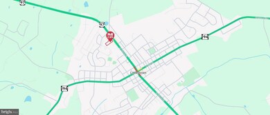
Map
Home Values in the Area
Average Home Value in this Area
Tax History
| Year | Tax Paid | Tax Assessment Tax Assessment Total Assessment is a certain percentage of the fair market value that is determined by local assessors to be the total taxable value of land and additions on the property. | Land | Improvement |
|---|---|---|---|---|
| 2025 | $3,533 | $153,700 | $153,700 | $0 |
| 2024 | $3,405 | $153,700 | $153,700 | $0 |
| 2023 | $3,273 | $153,700 | $153,700 | $0 |
| 2022 | $3,253 | $153,700 | $153,700 | $0 |
| 2021 | $3,157 | $153,700 | $153,700 | $0 |
| 2020 | $3,119 | $153,700 | $153,700 | $0 |
| 2019 | $3,026 | $153,700 | $153,700 | $0 |
| 2018 | $2,970 | $153,700 | $153,700 | $0 |
| 2017 | $2,894 | $153,700 | $153,700 | $0 |
| 2016 | -- | $153,700 | $153,700 | $0 |
| 2015 | -- | $153,700 | $153,700 | $0 |
| 2014 | -- | $153,700 | $153,700 | $0 |
Property History
| Date | Event | Price | List to Sale | Price per Sq Ft |
|---|---|---|---|---|
| 11/21/2025 11/21/25 | Price Changed | $360,000 | -9.8% | -- |
| 06/09/2025 06/09/25 | For Sale | $399,000 | -- | -- |
Purchase History
| Date | Type | Sale Price | Title Company |
|---|---|---|---|
| Deed | $127,000 | None Available | |
| Deed | $50,000 | -- |
Source: Bright MLS
MLS Number: PAAD2017784
APN: 27-004-0010A-000
Disclaimer: Certain information contained herein is derived from information provided by parties other than Homes.com. All information provided is deemed reliable, but is not guaranteed to be accurate and should be independently verified.
![]() The data relating to real estate for sale on this website appears in part through the BRIGHT Internet Data Exchange program, a voluntary cooperative exchange of property listing data between licensed real estate brokerage firms, and is provided by BRIGHT through a licensing agreement.
The data relating to real estate for sale on this website appears in part through the BRIGHT Internet Data Exchange program, a voluntary cooperative exchange of property listing data between licensed real estate brokerage firms, and is provided by BRIGHT through a licensing agreement.
Listing information is from various brokers who participate in the Bright MLS IDX program and not all listings may be visible on the site.
The property information being provided on or through the website is for the personal, non-commercial use of consumers and such information may not be used for any purpose other than to identify prospective properties consumers may be interested in purchasing.
Some properties which appear for sale on the website may no longer be available because they are for instance, under contract, sold or are no longer being offered for sale.
Property information displayed is deemed reliable but is not guaranteed.
Copyright 2025 Bright MLS, Inc.
- 140 Apple Grove Ln Unit 425
- 58 Windsor Ct
- 20c Locust Dr
- 0 Locust Dr Unit PAAD2015910
- 162 Newark St
- 161 Stoners Cir
- 22 Rita Marie Ave
- 115 Charles St
- 117 Charles St
- 106 E King St
- 61 E King St
- 211 E King St
- 41 Smith Cir
- 241 M St
- 1024 Frederick Pike Unit 6
- 535 Lumber St
- 559 Lumber St
- 567 Lumber St
- 1 Hickory Ln
- 43 Ashfield Dr Unit 14
- 102 Newark St
- 102 Newark St
- 102 Newark St
- 137 Roberta Jean Ave
- 128 Roberta Jean Ave
- 181 Cemetery St
- 515 S Queen St Unit First Floor
- 65 North St Unit 58
- 131 Main St
- 349 North St
- 86 N Blettner Ave
- 86 N Blettner Ave
- 211 N Oxford Ave
- 607 3rd St
- 324 3rd St Unit 324-1
- 414 S High St Unit 2nd FL
- 325 2nd Ave
- 432 S Franklin St
- 425 Carlisle St Unit 425.5 A
- 2 Clearview Ct