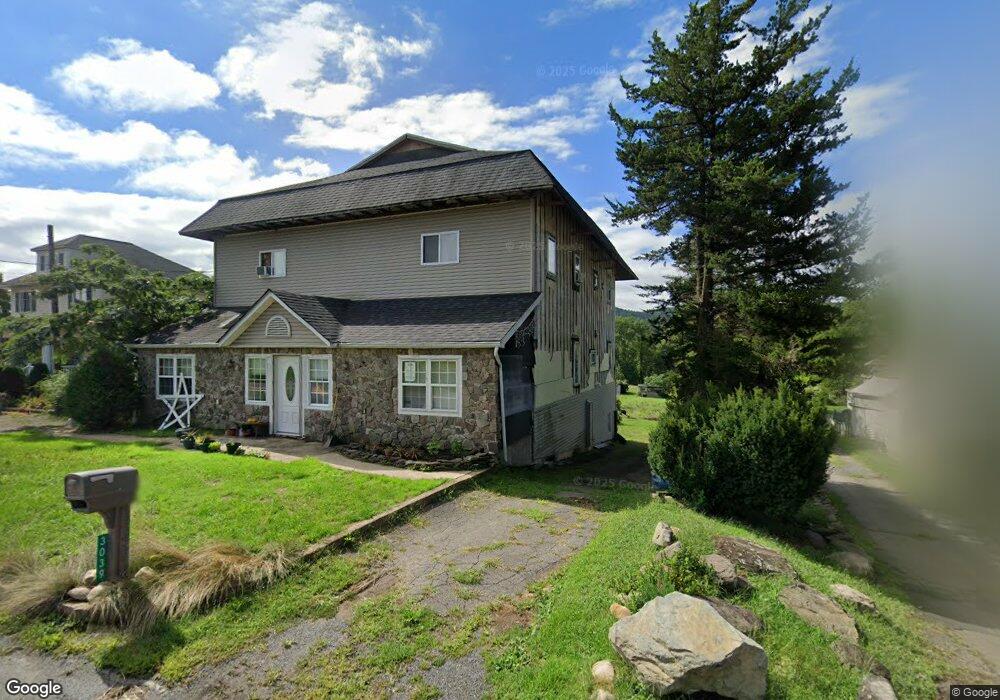
440 T-367 Ransom, PA 18653
Estimated Value: $370,000 - $473,000
--
Bed
--
Bath
--
Sq Ft
20
Acres
About This Home
This home is located at 440 T-367, Ransom, PA 18653 and is currently estimated at $421,500. 440 T-367 is a home with nearby schools including Abington Heights High School.
Ownership History
Date
Name
Owned For
Owner Type
Purchase Details
Closed on
Nov 26, 2012
Sold by
Jones Harold L and Jones Susan
Bought by
Township Of Ransom
Current Estimated Value
Purchase Details
Closed on
Aug 21, 2007
Sold by
Vandenhandel Leonard J
Bought by
Jones Harold and Jones Susan
Home Financials for this Owner
Home Financials are based on the most recent Mortgage that was taken out on this home.
Original Mortgage
$202,800
Interest Rate
6.78%
Mortgage Type
New Conventional
Create a Home Valuation Report for This Property
The Home Valuation Report is an in-depth analysis detailing your home's value as well as a comparison with similar homes in the area
Home Values in the Area
Average Home Value in this Area
Purchase History
| Date | Buyer | Sale Price | Title Company |
|---|---|---|---|
| Township Of Ransom | -- | None Available | |
| Jones Harold | $255,000 | None Available |
Source: Public Records
Mortgage History
| Date | Status | Borrower | Loan Amount |
|---|---|---|---|
| Previous Owner | Jones Harold | $202,800 |
Source: Public Records
Tax History Compared to Growth
Tax History
| Year | Tax Paid | Tax Assessment Tax Assessment Total Assessment is a certain percentage of the fair market value that is determined by local assessors to be the total taxable value of land and additions on the property. | Land | Improvement |
|---|---|---|---|---|
| 2025 | $7,081 | $29,700 | $5,900 | $23,800 |
| 2024 | $5,881 | $29,700 | $5,900 | $23,800 |
| 2023 | $4,554 | $23,000 | $5,900 | $17,100 |
| 2022 | $4,435 | $23,000 | $5,900 | $17,100 |
| 2021 | $4,435 | $23,000 | $5,900 | $17,100 |
| 2020 | $4,435 | $23,000 | $5,900 | $17,100 |
| 2019 | $4,286 | $23,000 | $5,900 | $17,100 |
| 2018 | $4,245 | $23,000 | $5,900 | $17,100 |
| 2017 | $4,222 | $23,000 | $5,900 | $17,100 |
| 2016 | $2,639 | $23,000 | $5,900 | $17,100 |
| 2015 | -- | $23,000 | $5,900 | $17,100 |
| 2014 | -- | $23,000 | $5,900 | $17,100 |
Source: Public Records
Map
Nearby Homes
- 2352 Newton Ransom Blvd
- 2356 Newton Ransom Blvd
- 2694 Ransom Rd
- 3018 Main St
- 3061 Main St
- 314 Terrace Ave
- 2304 Pennsylvania 92
- 9 Circle Dr
- 2225 Cherry Hill Rd
- 675 Apple Tree Rd
- 1932 Newton Ransom Blvd
- 522 Sutton Creek Rd
- 2441 Milwaukee Rd
- 0 Spring & Red Oak Dr Unit GSBSC1753
- 0 Milwaukee Rd Unit GSBSC254290
- 0 Lockville Rd Church Rd Unit 25-1114
- 242 Pauline St
- 711 Jean St
- 750 Slocum Ave
- 2500 Falls Rd
- 2147 Newton Ransom Blvd
- 2152 Newton Ransom Blvd
- 2150 Newton Ransom Blvd
- 2228 Newton Ransom Blvd
- 2154 Newton Ransom Blvd
- 2143 Newton Ransom Blvd
- 2146 Newton Ransom Blvd
- 2248 Sunset Dr
- 2208 Sunset Mobile Home Park
- 2210 Sunset Mobile Home Park
- 2212 Sunset Mobile Home Park
- 2240 Sunset Dr
- 2224 Sunset Mobile Home Park
- 2230 Sunset Mobile Home Park
- 2228 Sunset Mobile Home Park
- 2234 Sunset Mobile Home Park
- 2231 Sunset Mobile Home Park
- 2226 Sunset Mobile Home Park
- 2203 Sunset Mobile Home Park
- 2207 Sunset Mobile Home Park