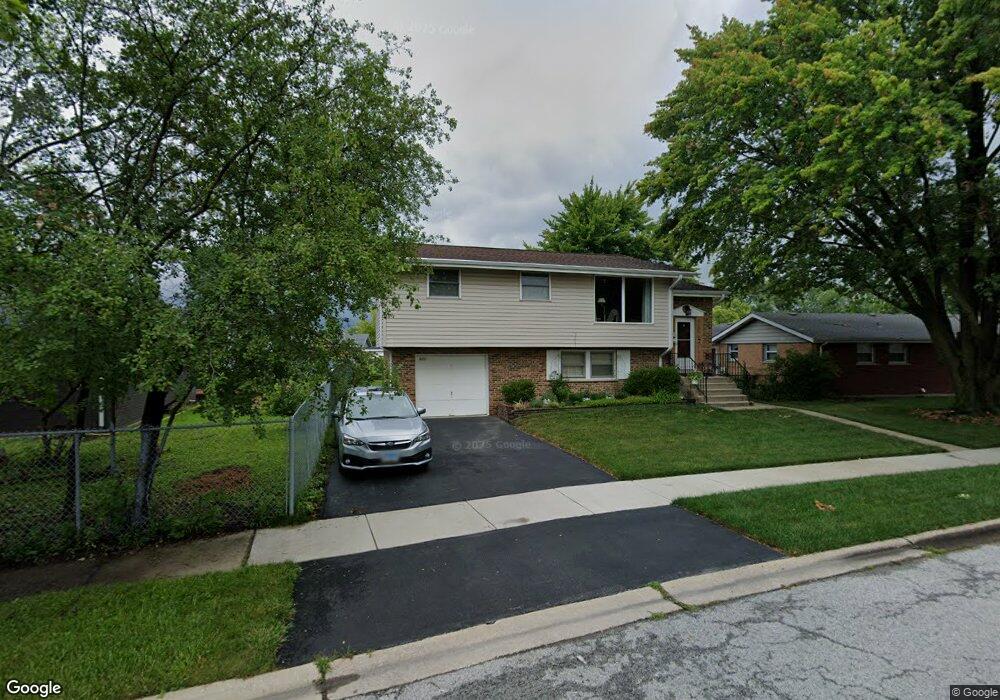
4404 Richard Ave Oak Forest, IL 60452
Estimated Value: $221,000 - $257,842
3
Beds
2
Baths
1,150
Sq Ft
$213/Sq Ft
Est. Value
About This Home
This home is located at 4404 Richard Ave, Oak Forest, IL 60452 and is currently estimated at $244,961, approximately $213 per square foot. 4404 Richard Ave is a home located in Cook County with nearby schools including Fieldcrest Elementary School, Prairie-Hills Junior High School, and Tinley Park High School.
Ownership History
Date
Name
Owned For
Owner Type
Purchase Details
Closed on
Jul 10, 1995
Sold by
Charleston Lawrence D and Charleston Susan H
Bought by
Schenkenfelder Edward J and Schenkenfelder Rebecca
Current Estimated Value
Home Financials for this Owner
Home Financials are based on the most recent Mortgage that was taken out on this home.
Original Mortgage
$111,000
Interest Rate
7.9%
Mortgage Type
FHA
Create a Home Valuation Report for This Property
The Home Valuation Report is an in-depth analysis detailing your home's value as well as a comparison with similar homes in the area
Home Values in the Area
Average Home Value in this Area
Purchase History
| Date | Buyer | Sale Price | Title Company |
|---|---|---|---|
| Schenkenfelder Edward J | -- | -- |
Source: Public Records
Mortgage History
| Date | Status | Borrower | Loan Amount |
|---|---|---|---|
| Closed | Schenkenfelder Edward J | $111,000 |
Source: Public Records
Tax History Compared to Growth
Tax History
| Year | Tax Paid | Tax Assessment Tax Assessment Total Assessment is a certain percentage of the fair market value that is determined by local assessors to be the total taxable value of land and additions on the property. | Land | Improvement |
|---|---|---|---|---|
| 2024 | $5,907 | $19,001 | $2,719 | $16,282 |
| 2023 | $5,212 | $19,001 | $2,719 | $16,282 |
| 2022 | $5,212 | $13,654 | $2,416 | $11,238 |
| 2021 | $5,094 | $13,654 | $2,416 | $11,238 |
| 2020 | $5,104 | $13,654 | $2,416 | $11,238 |
| 2019 | $5,582 | $14,979 | $2,265 | $12,714 |
| 2018 | $5,479 | $14,979 | $2,265 | $12,714 |
| 2017 | $5,263 | $14,979 | $2,265 | $12,714 |
| 2016 | $4,983 | $13,139 | $1,963 | $11,176 |
| 2015 | $4,710 | $13,139 | $1,963 | $11,176 |
| 2014 | $4,626 | $13,139 | $1,963 | $11,176 |
| 2013 | $4,335 | $13,851 | $1,963 | $11,888 |
Source: Public Records
Map
Nearby Homes
- 16453 Harold St
- 16465 Roy St
- 4401 Adele Ln
- 16520 Brenden Ln
- 16524 Brockton Ln
- 4348 Mann St
- 16409 Craig Dr
- 4230 Barry Ln
- 16224 S Cicero Ave
- 16740 Forest Ave
- 16104 Oak Ave
- 16934 Cicero Ave
- 16938 Cicero Ave
- 5112 Deerpath Rd Unit 4
- 15240 S Cicero Ave
- 3949 168th St
- 3824 Sunset Ave
- 5103 Elmwood Rd
- 3936 169th St
- 3830 167th Place
- 16480 Craig Dr
- 16476 Craig Dr
- 16469 Harold St
- 16500 Craig Dr
- 16465 Harold St
- 16472 Craig Dr
- 4407 Richard Ave
- 16476 Harold St
- 16461 Harold St
- 16504 Craig Dr
- 16468 Craig Dr
- 4411 Richard Ave
- 16481 Craig Dr
- 16479 Craig Dr
- 16472 Harold St
- 16475 Craig Dr
- 16468 Harold St
- 4416 Richard Ave
- 16501 Craig Dr
- 4415 Richard Ave