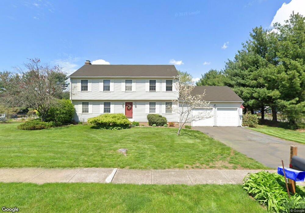
441 Buckland Dr Cheshire, CT 06410
Estimated Value: $624,000 - $693,000
4
Beds
3
Baths
2,265
Sq Ft
$293/Sq Ft
Est. Value
About This Home
This home is located at 441 Buckland Dr, Cheshire, CT 06410 and is currently estimated at $662,719, approximately $292 per square foot. 441 Buckland Dr is a home located in New Haven County with nearby schools including Darcey School, Highland School, and Dodd Middle School.
Ownership History
Date
Name
Owned For
Owner Type
Purchase Details
Closed on
May 31, 1996
Sold by
Lundy Stephen T and Lundy Bonnie L
Bought by
Katzman Robin K and Katzman Bruce J
Current Estimated Value
Purchase Details
Closed on
Nov 1, 1990
Sold by
Diversified Bldrs
Bought by
Lundy Stephen
Create a Home Valuation Report for This Property
The Home Valuation Report is an in-depth analysis detailing your home's value as well as a comparison with similar homes in the area
Home Values in the Area
Average Home Value in this Area
Purchase History
| Date | Buyer | Sale Price | Title Company |
|---|---|---|---|
| Katzman Robin K | $239,500 | -- | |
| Katzman Robin K | $239,500 | -- | |
| Lundy Stephen | $236,500 | -- |
Source: Public Records
Mortgage History
| Date | Status | Borrower | Loan Amount |
|---|---|---|---|
| Open | Lundy Stephen | $70,000 | |
| Open | Lundy Stephen | $280,000 | |
| Closed | Lundy Stephen | $18,000 |
Source: Public Records
Tax History Compared to Growth
Tax History
| Year | Tax Paid | Tax Assessment Tax Assessment Total Assessment is a certain percentage of the fair market value that is determined by local assessors to be the total taxable value of land and additions on the property. | Land | Improvement |
|---|---|---|---|---|
| 2025 | $10,330 | $347,340 | $95,060 | $252,280 |
| 2024 | $9,538 | $347,340 | $95,060 | $252,280 |
| 2023 | $8,824 | $251,460 | $95,080 | $156,380 |
| 2022 | $8,630 | $251,460 | $95,080 | $156,380 |
| 2021 | $5,793 | $251,460 | $95,080 | $156,380 |
| 2020 | $8,354 | $251,460 | $95,080 | $156,380 |
| 2019 | $8,354 | $251,460 | $95,080 | $156,380 |
| 2018 | $5,683 | $264,810 | $102,140 | $162,670 |
| 2017 | $8,458 | $264,810 | $102,140 | $162,670 |
| 2016 | $8,127 | $264,810 | $102,140 | $162,670 |
| 2015 | $8,127 | $264,810 | $102,140 | $162,670 |
| 2014 | $8,011 | $264,810 | $102,140 | $162,670 |
Source: Public Records
Map
Nearby Homes
- 315 Greens Loop Unit 315
- 294 Greenwood Dr
- 120 Scenic Ct
- 689 S Meriden Rd
- 0 S Meriden Rd Unit 3
- 2 Tunxis Place
- 749 S Meriden Rd
- 278 Wiese Rd
- 324 S Meriden Rd
- 17 Melrose Dr Unit Lot 3
- 21 Melrose Dr Unit Lot 2
- 458 Castle Glenn
- 241 Beacon Hill Dr
- 3 Melrose Dr Unit Lot 9
- 435 Maple Ave
- 471 E Mitchell Ave
- 1343 Diamond Hill Rd
- 1278 Cheshire St
- 6 Melrose Dr Unit Lot 10
- 9 Melrose Dr Unit 6
- 449 Buckland Dr
- 686 Wiese Rd
- 678 Wiese Rd
- 442 Buckland Dr
- 424 Country Club Rd
- 670 Wiese Rd
- 457 Buckland Dr
- 662 Wiese Rd
- 404 Country Club Rd
- 442 Country Club Rd
- 654 Wiese Rd
- 397 Country Club Rd
- 465 Buckland Dr
- 472 Buckland Dr
- 388 Greenwood Dr
- 20 Scenic Ct
- 646 Wiese Rd
- 481 Country Club Rd
- 5 Applewood Dr
- 657 Wiese Rd