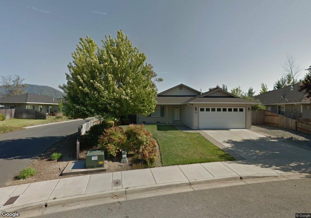
441 Marion Ln Grants Pass, OR 97527
Estimated Value: $451,721 - $495,000
4
Beds
4
Baths
2,124
Sq Ft
$223/Sq Ft
Est. Value
About This Home
This home is located at 441 Marion Ln, Grants Pass, OR 97527 and is currently estimated at $473,361, approximately $222 per square foot. 441 Marion Ln is a home located in Josephine County with nearby schools including Parkside Elementary School, South Middle School, and Grants Pass High School.
Ownership History
Date
Name
Owned For
Owner Type
Purchase Details
Closed on
Apr 25, 2013
Sold by
Kamins Birthe H and Kamins Paul B
Bought by
Birthe H & Paul B Kamins Revocable Trust
Current Estimated Value
Purchase Details
Closed on
Jan 26, 2011
Sold by
Fitzgerald Tongta
Bought by
Fitzgerald Van
Purchase Details
Closed on
Jan 24, 2011
Sold by
Fitzgerald Van
Bought by
Kamins Paul and Kamins Birthe
Purchase Details
Closed on
Aug 15, 2005
Sold by
R Crume Construction Inc
Bought by
Fitzgerald Van
Home Financials for this Owner
Home Financials are based on the most recent Mortgage that was taken out on this home.
Original Mortgage
$236,700
Interest Rate
3%
Mortgage Type
Fannie Mae Freddie Mac
Purchase Details
Closed on
Jan 21, 2005
Sold by
R Crume Construction Inc
Bought by
R Crume Construction Inc
Create a Home Valuation Report for This Property
The Home Valuation Report is an in-depth analysis detailing your home's value as well as a comparison with similar homes in the area
Home Values in the Area
Average Home Value in this Area
Purchase History
| Date | Buyer | Sale Price | Title Company |
|---|---|---|---|
| Birthe H & Paul B Kamins Revocable Trust | -- | None Available | |
| Fitzgerald Van | -- | First American Title | |
| Kamins Paul | $200,000 | First American | |
| Fitzgerald Van | $295,900 | Ticor Title | |
| R Crume Construction Inc | -- | Ticor Title |
Source: Public Records
Mortgage History
| Date | Status | Borrower | Loan Amount |
|---|---|---|---|
| Previous Owner | Fitzgerald Van | $236,700 |
Source: Public Records
Tax History Compared to Growth
Tax History
| Year | Tax Paid | Tax Assessment Tax Assessment Total Assessment is a certain percentage of the fair market value that is determined by local assessors to be the total taxable value of land and additions on the property. | Land | Improvement |
|---|---|---|---|---|
| 2025 | $3,198 | $246,250 | -- | -- |
| 2024 | $3,198 | $239,080 | -- | -- |
| 2023 | $3,012 | $232,120 | $0 | $0 |
| 2022 | $3,026 | $225,360 | -- | -- |
| 2021 | $2,842 | $218,800 | $0 | $0 |
| 2020 | $2,760 | $212,430 | $0 | $0 |
| 2019 | $2,681 | $206,250 | $0 | $0 |
| 2018 | $2,728 | $200,250 | $0 | $0 |
| 2017 | $2,707 | $194,420 | $0 | $0 |
| 2016 | $2,380 | $188,760 | $0 | $0 |
| 2015 | $2,302 | $183,270 | $0 | $0 |
| 2014 | $2,239 | $177,940 | $0 | $0 |
Source: Public Records
Map
Nearby Homes
- 423 W Park St
- 333 W Park St
- 444 Union Ave Unit TL 1700
- 444 Union Ave Unit TL 1600
- 1219 River Ln
- 955 SW Rogue River Ave
- 115 Rogue River Hwy Unit 302
- 115 Rogue River Hwy Unit 307
- 1202 SW Viola Dr
- 1129 SW Ballinger Dr
- 0 Fruitdale Lilac Hilltop Shepha Dr Unit 220196701
- 0 Ramsey Southwest Ave SW Unit 220201654
- 426 SE Cadet Ct
- 253 SW Central Ave
- 11311133 SW Central Ave
- 1764 Harbeck Rd
- 1626 Poplar Dr
- 1710 SW Brownell Ave
- 185 Independence Dr
- 101 SE Liberty Dr