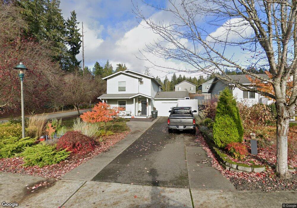
441 NE Max William Loop Poulsbo, WA 98370
Estimated Value: $485,000 - $506,000
3
Beds
3
Baths
1,256
Sq Ft
$392/Sq Ft
Est. Value
About This Home
This home is located at 441 NE Max William Loop, Poulsbo, WA 98370 and is currently estimated at $491,782, approximately $391 per square foot. 441 NE Max William Loop is a home located in Kitsap County with nearby schools including Vinland Elementary School, Poulsbo Middle School, and North Kitsap High School.
Ownership History
Date
Name
Owned For
Owner Type
Purchase Details
Closed on
Oct 15, 2014
Sold by
Allbee Carly A and Allbee Christopher J
Bought by
Allbee Carly A and Allbee Christopher J
Current Estimated Value
Home Financials for this Owner
Home Financials are based on the most recent Mortgage that was taken out on this home.
Original Mortgage
$144,130
Outstanding Balance
$103,629
Interest Rate
2.5%
Mortgage Type
Adjustable Rate Mortgage/ARM
Estimated Equity
$388,153
Purchase Details
Closed on
Mar 2, 2007
Sold by
Kitsap Cnty Consolidated Hsng Authority
Bought by
Roney Carly A
Home Financials for this Owner
Home Financials are based on the most recent Mortgage that was taken out on this home.
Original Mortgage
$30,000
Interest Rate
6.29%
Mortgage Type
Stand Alone Second
Create a Home Valuation Report for This Property
The Home Valuation Report is an in-depth analysis detailing your home's value as well as a comparison with similar homes in the area
Home Values in the Area
Average Home Value in this Area
Purchase History
| Date | Buyer | Sale Price | Title Company |
|---|---|---|---|
| Allbee Carly A | -- | Pacific Northwest Title | |
| Roney Carly A | -- | Pacific Nw Title |
Source: Public Records
Mortgage History
| Date | Status | Borrower | Loan Amount |
|---|---|---|---|
| Open | Allbee Carly A | $144,130 | |
| Closed | Roney Carly A | $30,000 | |
| Closed | Roney Carly A | $150,000 |
Source: Public Records
Tax History Compared to Growth
Tax History
| Year | Tax Paid | Tax Assessment Tax Assessment Total Assessment is a certain percentage of the fair market value that is determined by local assessors to be the total taxable value of land and additions on the property. | Land | Improvement |
|---|---|---|---|---|
| 2026 | $4,096 | $465,480 | $135,140 | $330,340 |
| 2025 | $4,096 | $465,480 | $135,140 | $330,340 |
| 2024 | $3,507 | $410,790 | $126,370 | $284,420 |
| 2023 | $3,566 | $410,790 | $126,370 | $284,420 |
| 2022 | $3,169 | $347,630 | $109,700 | $237,930 |
| 2021 | $3,065 | $311,600 | $98,290 | $213,310 |
| 2020 | $2,978 | $297,640 | $93,900 | $203,740 |
| 2019 | $2,791 | $279,200 | $87,760 | $191,440 |
| 2018 | $2,588 | $220,060 | $66,640 | $153,420 |
| 2017 | $2,467 | $220,060 | $66,640 | $153,420 |
| 2016 | $2,546 | $209,100 | $66,640 | $142,460 |
| 2015 | $2,465 | $203,620 | $66,640 | $136,980 |
| 2014 | -- | $163,290 | $55,530 | $107,760 |
| 2013 | -- | $163,290 | $55,530 | $107,760 |
Source: Public Records
Map
Nearby Homes
- 434 NE Ohenry Ct
- 402 NE Inspiration St
- 31200 Washington 3
- 263 NE Max William Loop
- 0 xxx Big Valley Rd
- 21772 NW Monterey Loop
- 21032 Nordby Dr NW
- 21988 Urdahl Rd NW
- 21756 Windmill Loop NW
- 21728 Urdahl Rd NW
- 22121 Jameson Ave NW
- 456 Little Valley Rd NE
- 0 Bond Rd NE
- 1430 NW Swenson Ct
- 1430 NW Swenson Ct Unit 24
- 21555 Urdahl Rd NW
- 22176 Jameson Ave NW Unit 84
- 22200 Jameson Ave NW Unit 25
- 22157 Calvin Place NW
- 22157 Calvin Place NW Unit 82
- 437 NE Max William Loop
- 438 NE Ohenry Ct
- 431 NE Max William Loop
- 430 NE Ohenry Ct
- 428 NE Ohenry Ct
- 22172 Viking Ave NW
- 438 NE Max William Loop
- 427 NE Max William Loop
- 426 NE Ohenry Ct
- 432 NE Max William Loop
- 424 NE Ohenry Ct
- 428 NE Max William Loop
- 22192 Viking Ave NW
- 424 NE O'Henry Ct
- 421 NE Max William Loop
- 420 NE Ohenry Ct
- 420 NE O'Henry Ct
- 422 NE Max William Loop
- 22199 Jordy Place NE
- 417 NE Max William Loop