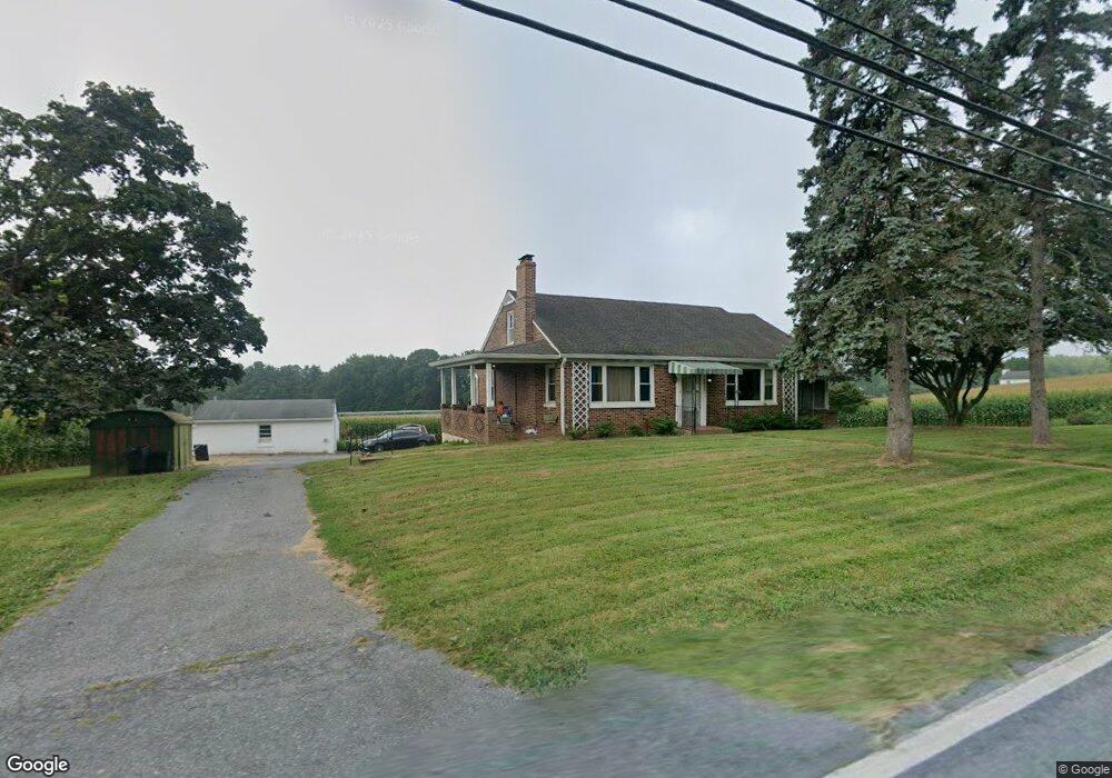
4411 Black Rock Rd Hampstead, MD 21074
Estimated Value: $384,029 - $453,000
3
Beds
1
Bath
1,973
Sq Ft
$206/Sq Ft
Est. Value
About This Home
This home is located at 4411 Black Rock Rd, Hampstead, MD 21074 and is currently estimated at $406,257, approximately $205 per square foot. 4411 Black Rock Rd is a home located in Carroll County with nearby schools including Spring Garden Elementary School, Shiloh Middle School, and Manchester Valley High School.
Ownership History
Date
Name
Owned For
Owner Type
Purchase Details
Closed on
Jun 8, 2015
Sold by
Estate Of Helen G Lawson
Bought by
Lawson Robert D
Current Estimated Value
Purchase Details
Closed on
Jan 7, 2015
Sold by
Lawson Robert D
Bought by
Estate Of Helen G Lawson
Purchase Details
Closed on
May 31, 2001
Sold by
Lawson George W
Bought by
Lawson George W and Lawson Helen G
Create a Home Valuation Report for This Property
The Home Valuation Report is an in-depth analysis detailing your home's value as well as a comparison with similar homes in the area
Home Values in the Area
Average Home Value in this Area
Purchase History
| Date | Buyer | Sale Price | Title Company |
|---|---|---|---|
| Lawson Robert D | -- | Attorney | |
| Estate Of Helen G Lawson | -- | None Available | |
| Lawson George W | -- | -- |
Source: Public Records
Tax History Compared to Growth
Tax History
| Year | Tax Paid | Tax Assessment Tax Assessment Total Assessment is a certain percentage of the fair market value that is determined by local assessors to be the total taxable value of land and additions on the property. | Land | Improvement |
|---|---|---|---|---|
| 2025 | $3,278 | $315,100 | $123,100 | $192,000 |
| 2024 | $3,278 | $292,733 | $0 | $0 |
| 2023 | $3,088 | $270,367 | $0 | $0 |
| 2022 | $2,837 | $248,000 | $104,700 | $143,300 |
| 2021 | $2,833 | $247,600 | $0 | $0 |
| 2020 | $2,828 | $247,200 | $0 | $0 |
| 2019 | $2,849 | $246,800 | $104,700 | $142,100 |
| 2018 | $2,807 | $245,267 | $0 | $0 |
| 2017 | $2,789 | $243,733 | $0 | $0 |
| 2016 | -- | $242,200 | $0 | $0 |
| 2015 | -- | $241,167 | $0 | $0 |
| 2014 | -- | $240,133 | $0 | $0 |
Source: Public Records
Map
Nearby Homes
- 1003 Scarlet Oak Ct Unit 1A
- 1124 Cedarbrook Rd
- 1208 Wynside Ln
- 4240 Crystal Ct Unit 3D
- 4230 Crystal Ct Unit 3C
- 4138 Hillcrest Ave
- 1330 N Main St
- 4703 Barbed Ct
- 920 N Houcksville Rd
- 613 Hanover Pike
- 1151 Caton Rd
- 0 Hanover Pike Unit MDCR2024542
- 1410 N Main St
- 4131 Shanelle Ct
- 3836 Dakota Rd
- 1368 Lare St
- 1175 Caton Rd
- 4150 Sommerfield Dr
- 3860 Normandy Dr Unit 1C
- 3911 Sunset Dr
- 0 Black Rock Rd Unit 1007822700
- 0 Black Rock Rd Unit 1007174814
- 0 Black Rock Rd Unit MDCR182462
- 0 Black Rock Rd Unit 1000868120
- 0 Black Rock Rd Unit 1004638414
- 4322 Black Rock Rd
- 4324 Black Rock Rd
- 4321 Black Rock Rd
- 4320 Black Rock Rd
- 4506 Lower Beckleysville Rd Unit D,G,H,I,J,K
- 4506 Lower Beckleysville Rd
- 4313 Black Rock Rd
- 4316 Black Rock Rd
- 1018 Boxwood Dr
- 1015 Boxwood Dr
- 1016 Boxwood Dr
- 4324 Dogwood Dr
- 4309 Black Rock Rd
- 4322 Dogwood Dr
- 4312 Black Rock Rd