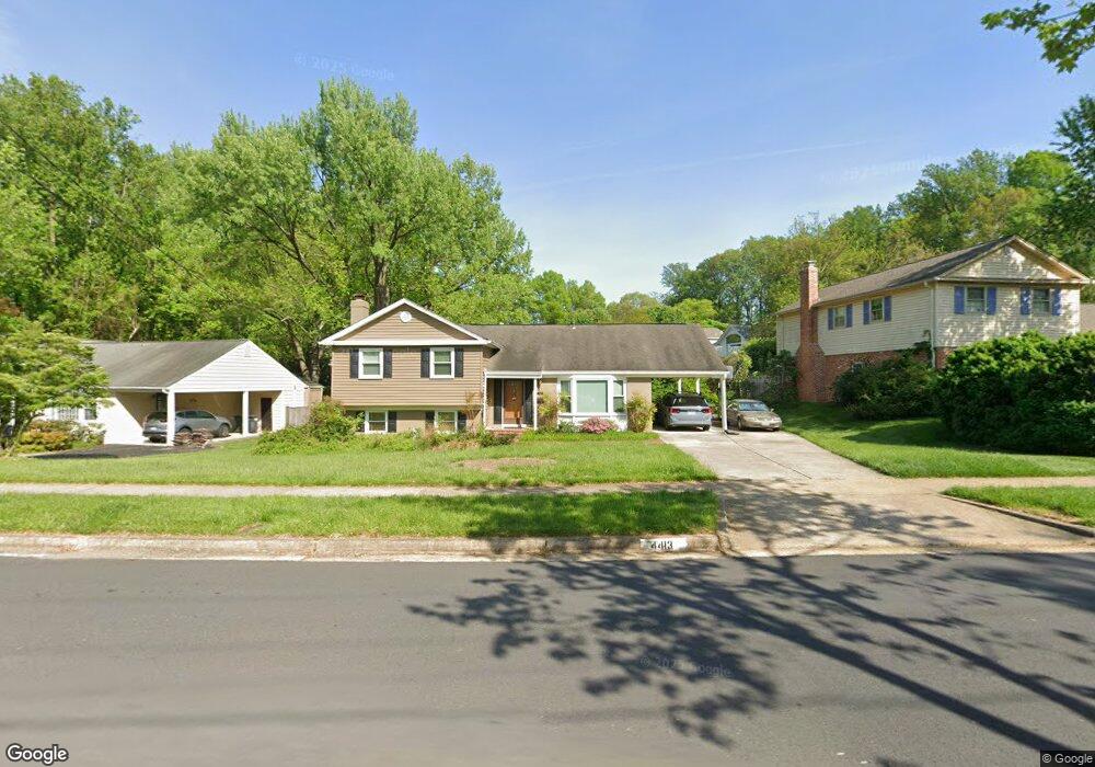
4413 Duncan Dr Annandale, VA 22003
Estimated Value: $833,000 - $903,000
5
Beds
3
Baths
1,608
Sq Ft
$540/Sq Ft
Est. Value
About This Home
This home is located at 4413 Duncan Dr, Annandale, VA 22003 and is currently estimated at $867,672, approximately $539 per square foot. 4413 Duncan Dr is a home located in Fairfax County with nearby schools including Wakefield Forest Elementary School, Frost Middle School, and W. T. Woodson High School.
Ownership History
Date
Name
Owned For
Owner Type
Purchase Details
Closed on
Nov 24, 1999
Sold by
Yang Kenneth Chi Kun
Bought by
Chang Jon C
Current Estimated Value
Home Financials for this Owner
Home Financials are based on the most recent Mortgage that was taken out on this home.
Original Mortgage
$215,900
Outstanding Balance
$66,013
Interest Rate
7.77%
Estimated Equity
$801,659
Create a Home Valuation Report for This Property
The Home Valuation Report is an in-depth analysis detailing your home's value as well as a comparison with similar homes in the area
Home Values in the Area
Average Home Value in this Area
Purchase History
| Date | Buyer | Sale Price | Title Company |
|---|---|---|---|
| Chang Jon C | $269,900 | -- |
Source: Public Records
Mortgage History
| Date | Status | Borrower | Loan Amount |
|---|---|---|---|
| Open | Chang Jon C | $215,900 |
Source: Public Records
Tax History Compared to Growth
Tax History
| Year | Tax Paid | Tax Assessment Tax Assessment Total Assessment is a certain percentage of the fair market value that is determined by local assessors to be the total taxable value of land and additions on the property. | Land | Improvement |
|---|---|---|---|---|
| 2025 | $8,969 | $813,490 | $310,000 | $503,490 |
| 2024 | $8,969 | $774,220 | $285,000 | $489,220 |
| 2023 | $8,825 | $782,000 | $285,000 | $497,000 |
| 2022 | $8,335 | $728,870 | $260,000 | $468,870 |
| 2021 | $7,712 | $657,200 | $240,000 | $417,200 |
| 2020 | $7,235 | $611,300 | $225,000 | $386,300 |
| 2019 | $7,042 | $594,990 | $210,000 | $384,990 |
| 2018 | $6,632 | $576,660 | $210,000 | $366,660 |
| 2017 | $6,695 | $576,660 | $210,000 | $366,660 |
| 2016 | $6,517 | $562,560 | $210,000 | $352,560 |
| 2015 | $6,278 | $562,560 | $210,000 | $352,560 |
| 2014 | $6,032 | $541,720 | $200,000 | $341,720 |
Source: Public Records
Map
Nearby Homes
- 8112 Briar Creek Dr
- 4410 Woodchuck Ct
- 8221 Captain Hawkins Ct
- 4217 N Valiant Ct
- 4603 Holborn Ave
- 4208 Duncan Dr
- 8312 Upper Spring Ln
- 4101 High Point Ct
- 7905 Dassett Ct Unit 304
- 8310 Upper Spring Ln
- 4408 Island Place Unit 202
- 8317 Little River Turnpike
- 4304 Wakefield Chapel Rd
- 7809 Dassett Ct Unit 101
- 7804 Inverton Rd Unit 201
- 4367 Americana Dr Unit 104
- 8510 Ordinary Way
- 4921 Americana Dr Unit 102
- 4900 Schuyler Dr
- 4302 Wakefield Dr
- 4411 Duncan Dr
- 4415 Duncan Dr
- 8119 Briar Creek Dr
- 8121 Briar Creek Dr
- 4414 Duncan Dr
- 4412 Duncan Dr
- 4416 Duncan Dr
- 4410 Duncan Dr
- 4419 Duncan Dr
- 8123 Briar Creek Dr
- 8120 Briar Creek Dr
- 8113 Briar Creek Dr
- 4418 Duncan Dr
- 8125 Briar Creek Dr
- 4421 Duncan Dr
- 8109 Briar Creek Dr
- 8124 Briar Creek Dr
- 8114 Briar Creek Dr
- 4420 Duncan Dr
- 4400 Duncan Dr