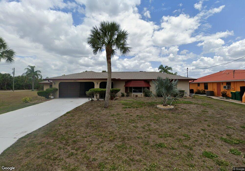
4416 Tatum St Port Charlotte, FL 33948
Estimated Value: $425,000 - $553,000
3
Beds
2
Baths
1,883
Sq Ft
$261/Sq Ft
Est. Value
About This Home
This home is located at 4416 Tatum St, Port Charlotte, FL 33948 and is currently estimated at $490,972, approximately $260 per square foot. 4416 Tatum St is a home located in Charlotte County with nearby schools including Meadow Park Elementary School, Murdock Middle School, and Port Charlotte High School.
Ownership History
Date
Name
Owned For
Owner Type
Purchase Details
Closed on
Sep 15, 2023
Sold by
David Julie M and David Therese M
Bought by
Julie David And Therese M Evan Revocable Trus and Evan
Current Estimated Value
Purchase Details
Closed on
Apr 19, 2022
Sold by
David George D
Bought by
David Julie M
Purchase Details
Closed on
Apr 7, 2022
Sold by
Annette M David Revocable Living Trust
Bought by
David Julie M and David George D
Purchase Details
Closed on
Apr 21, 2018
Sold by
David Julie M and David George D
Bought by
David Julie M and David George D
Purchase Details
Closed on
Jun 27, 2002
Sold by
David Annette M and David George D
Bought by
David Annette M
Create a Home Valuation Report for This Property
The Home Valuation Report is an in-depth analysis detailing your home's value as well as a comparison with similar homes in the area
Home Values in the Area
Average Home Value in this Area
Purchase History
| Date | Buyer | Sale Price | Title Company |
|---|---|---|---|
| Julie David And Therese M Evan Revocable Trus | $100 | None Listed On Document | |
| David Julie M | -- | None Listed On Document | |
| David Julie M | -- | Brady Law Office Pa | |
| David Julie M | -- | Attorney | |
| David Annette M | -- | -- |
Source: Public Records
Tax History Compared to Growth
Tax History
| Year | Tax Paid | Tax Assessment Tax Assessment Total Assessment is a certain percentage of the fair market value that is determined by local assessors to be the total taxable value of land and additions on the property. | Land | Improvement |
|---|---|---|---|---|
| 2023 | $8,075 | $408,071 | $146,200 | $261,871 |
| 2022 | $6,800 | $363,677 | $121,550 | $242,127 |
| 2021 | $6,140 | $276,581 | $63,325 | $213,256 |
| 2020 | $5,808 | $257,140 | $58,650 | $198,490 |
| 2019 | $5,107 | $261,222 | $58,650 | $202,572 |
| 2018 | $4,517 | $242,491 | $56,015 | $186,476 |
| 2017 | $4,179 | $212,672 | $43,945 | $168,727 |
| 2016 | $3,947 | $182,349 | $0 | $0 |
| 2015 | $3,716 | $165,772 | $0 | $0 |
| 2014 | $3,332 | $150,702 | $0 | $0 |
Source: Public Records
Map
Nearby Homes
- 18053 Cullman Ave
- 4440 Tatum St
- 18049 Republic Ave
- 18065 Republic Ave
- 4441 Collingswood Blvd
- 18065 Wing Ave
- 18116 Wolbrette Cir
- 4390 Wischamper St
- 18048,18040, 18056 Wing Ave
- 18037 Ackerman Ave
- 4468 Sutlive St
- 18124 Wolbrette Cir
- 18020 Ohara Dr
- 18237 Bracken Cir
- 18305 Wolbrette Cir
- 4497 Bayview St
- 4466 Bayview St
- 18053 Ohara Dr
- 18037 Ohara Dr
- 18103 Lake Worth Blvd
- 4424 Tatum St
- 4432 Tatum St
- 18024 Cullman Ave
- 4433 Tatum St
- 4440 Street
- 18069 Cullman Ave
- 18009 Cullman Ave
- 18064 Cullman Ave
- 18041 Republic Ave
- 4424 Collingswood Blvd
- 18177 Wolbrette Cir
- 18057 Republic Ave
- 18025 Republic Ave
- 4448 Tatum St
- 4449 Tatum St
- 4441 Tatum St
- 4440 Collingswood Blvd
- 4456 Tatum St
- 18185 Wolbrette Cir