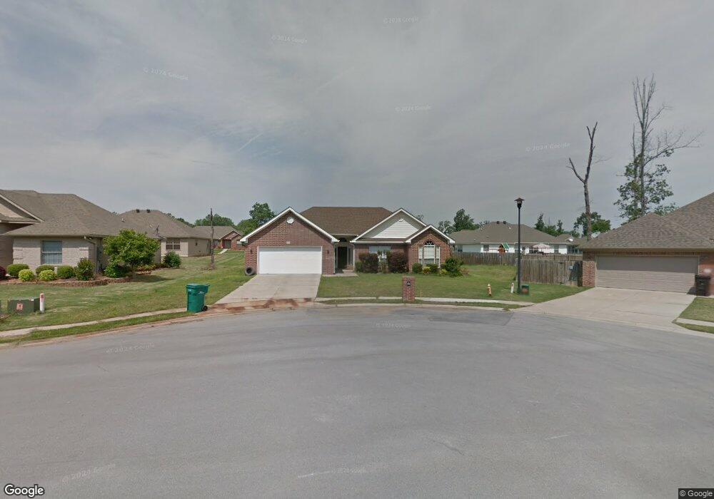
4417 Mandy Cir Benton, AR 72015
Estimated Value: $222,765 - $240,000
3
Beds
2
Baths
1,466
Sq Ft
$158/Sq Ft
Est. Value
About This Home
This home is located at 4417 Mandy Cir, Benton, AR 72015 and is currently estimated at $230,941, approximately $157 per square foot. 4417 Mandy Cir is a home located in Saline County with nearby schools including Hurricane Creek Elementary School and Arkansas Christian Academy.
Ownership History
Date
Name
Owned For
Owner Type
Purchase Details
Closed on
Mar 6, 2008
Sold by
Pannell Heather Reaves and Pannell Clint
Bought by
Parnell Jason M and Parnell Amy L
Current Estimated Value
Home Financials for this Owner
Home Financials are based on the most recent Mortgage that was taken out on this home.
Original Mortgage
$114,400
Outstanding Balance
$71,001
Interest Rate
5.67%
Mortgage Type
New Conventional
Estimated Equity
$159,940
Purchase Details
Closed on
Apr 22, 2005
Sold by
Chris Young Llc
Bought by
Reaves Heather
Home Financials for this Owner
Home Financials are based on the most recent Mortgage that was taken out on this home.
Original Mortgage
$126,600
Interest Rate
6.84%
Mortgage Type
Adjustable Rate Mortgage/ARM
Purchase Details
Closed on
Nov 18, 2004
Bought by
C Young Co
Create a Home Valuation Report for This Property
The Home Valuation Report is an in-depth analysis detailing your home's value as well as a comparison with similar homes in the area
Home Values in the Area
Average Home Value in this Area
Purchase History
| Date | Buyer | Sale Price | Title Company |
|---|---|---|---|
| Parnell Jason M | -- | None Available | |
| Reaves Heather | $127,000 | -- | |
| C Young Co | $23,000 | -- | |
| C Young Co | $23,000 | -- |
Source: Public Records
Mortgage History
| Date | Status | Borrower | Loan Amount |
|---|---|---|---|
| Open | Parnell Jason M | $114,400 | |
| Previous Owner | Reaves Heather | $126,600 |
Source: Public Records
Tax History
| Year | Tax Paid | Tax Assessment Tax Assessment Total Assessment is a certain percentage of the fair market value that is determined by local assessors to be the total taxable value of land and additions on the property. | Land | Improvement |
|---|---|---|---|---|
| 2025 | $1,821 | $36,451 | $6,400 | $30,051 |
| 2024 | $1,730 | $36,451 | $6,400 | $30,051 |
| 2023 | $1,317 | $36,451 | $6,400 | $30,051 |
| 2022 | $1,288 | $36,451 | $6,400 | $30,051 |
| 2021 | $1,215 | $29,280 | $5,400 | $23,880 |
| 2020 | $1,215 | $29,280 | $5,400 | $23,880 |
| 2019 | $1,215 | $29,280 | $5,400 | $23,880 |
| 2018 | $1,237 | $29,280 | $5,400 | $23,880 |
| 2017 | $1,176 | $29,280 | $5,400 | $23,880 |
| 2016 | $1,379 | $26,820 | $5,400 | $21,420 |
| 2015 | $1,379 | $26,820 | $5,400 | $21,420 |
| 2014 | $1,029 | $26,820 | $5,400 | $21,420 |
Source: Public Records
Map
Nearby Homes
- 000 Alcoa Rd
- 6226 Alcoa Rd
- 3018 Dapple Gray Rd
- 2421 Kenneth Dr
- 3702 Buckskin Rd
- 3475 Bay Meadow Dr
- 3712 Hazelwood Dr
- 3158 Stonewall Dr
- 1020 Raven Walk Dr
- 1092 Raven Walk Dr
- 1016 Raven Walk Dr
- 1032 Raven Walk Dr
- 1012 Raven Walk Dr
- 1044 Raven Walk Dr
- 1056 Raven Walk Dr
- 1052 Raven Walk Dr
- 1088 Raven Walk Dr
- 1024 Raven Walk Dr
- 1028 Raven Walk Dr
- 1040 Raven Walk Dr
Your Personal Tour Guide
Ask me questions while you tour the home.