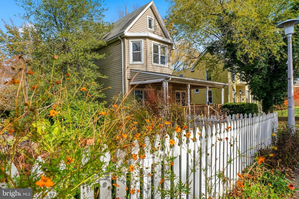

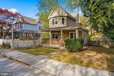


442 Rosebank Ave Baltimore, MD 21212
Rosebank NeighborhoodEstimated payment $2,050/month
Highlights
- Very Popular Property
- Farmhouse Style Home
- No HOA
- Deck
- Attic
- Porch
About This Home
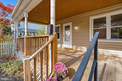
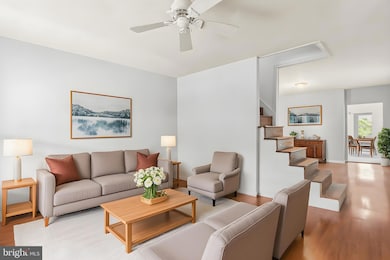
Experience the charm and character of this 1910 farmhouse-style home, ideally located in the sought-after Belvedere Square area. The quaint home is just a short stroll from the iconic Senator Theatre, local shops, and beloved restaurants. Offering 1,930 square feet of potential, this detached residence features classic appeal and generous living spaces, ready for your personal vision. The main level includes a spacious bedroom and a full bath, creating a convenient option for single-level living. You'll also find a large kitchen with ample cabinetry and countertop space, along with a main-floor laundry room for everyday ease. Upstairs offers flexibility with 2–3 additional bedrooms, a second full bath, and a bonus second kitchen and laundry area, plus direct access to the backyard which is ideal for multi-generational living or creative re-imagining. The finished attic provides even more opportunity to expand your living space. Enjoy outdoor living on the welcoming front porch or host gatherings on the backyard patio overlooking the expansive 0.22-acre lot, complete with a large fenced yard and side yard. A paved apron in front offers the potential for a future driveway, with ample street parking available. With walkability to entertainment, dining, and convenient amenities, this home is perfectly positioned to enjoy the best of the community. This property offers tremendous space, charm, and opportunity to create the home of your dreams.
Home Details
Home Type
- Single Family
Est. Annual Taxes
- $5,718
Year Built
- Built in 1910
Lot Details
- 9,583 Sq Ft Lot
- Level Lot
- Back Yard Fenced and Side Yard
- Property is zoned R-6
Home Design
- Farmhouse Style Home
- Block Foundation
- Poured Concrete
- Shingle Roof
- Vinyl Siding
Interior Spaces
- 1,930 Sq Ft Home
- Property has 3.5 Levels
- Ceiling height of 9 feet or more
- Ceiling Fan
- Living Room
- Dining Room
- Storage Room
- Utility Room
- Attic
Kitchen
- Eat-In Kitchen
- Gas Oven or Range
- Dishwasher
Bedrooms and Bathrooms
- Walk-In Closet
Laundry
- Laundry Room
- Laundry on main level
- Dryer
- Washer
Unfinished Basement
- English Basement
- Connecting Stairway
- Interior Basement Entry
Parking
- 1 Parking Space
- 1 Driveway Space
- Alley Access
- Dirt Driveway
- On-Street Parking
Accessible Home Design
- Level Entry For Accessibility
Outdoor Features
- Deck
- Patio
- Porch
Utilities
- Radiator
- Natural Gas Water Heater
- Private Sewer
Community Details
- No Home Owners Association
- Old Homeland Subdivision
Listing and Financial Details
- Tax Lot 022
- Assessor Parcel Number 0327645093B022
Map
Home Values in the Area
Average Home Value in this Area
Tax History
| Year | Tax Paid | Tax Assessment Tax Assessment Total Assessment is a certain percentage of the fair market value that is determined by local assessors to be the total taxable value of land and additions on the property. | Land | Improvement |
|---|---|---|---|---|
| 2025 | $4,953 | $242,267 | -- | -- |
| 2024 | $4,953 | $225,300 | $94,400 | $130,900 |
| 2023 | $4,867 | $222,467 | $0 | $0 |
| 2022 | $4,683 | $219,633 | $0 | $0 |
| 2021 | $5,116 | $216,800 | $94,400 | $122,400 |
| 2020 | $4,333 | $215,367 | $0 | $0 |
| 2019 | $4,139 | $213,933 | $0 | $0 |
| 2018 | $4,046 | $212,500 | $94,400 | $118,100 |
| 2017 | $3,923 | $209,900 | $0 | $0 |
| 2016 | $3,360 | $207,300 | $0 | $0 |
| 2015 | $3,360 | $204,700 | $0 | $0 |
| 2014 | $3,360 | $204,700 | $0 | $0 |
Property History
| Date | Event | Price | List to Sale | Price per Sq Ft |
|---|---|---|---|---|
| 12/04/2025 12/04/25 | Price Changed | $299,900 | -7.7% | $155 / Sq Ft |
| 11/07/2025 11/07/25 | For Sale | $325,000 | -- | $168 / Sq Ft |
Purchase History
| Date | Type | Sale Price | Title Company |
|---|---|---|---|
| Deed | -- | -- | |
| Deed | -- | -- | |
| Deed | $197,500 | -- |
Source: Bright MLS
MLS Number: MDBA2190302
APN: 5093B-022
Disclaimer: Certain information contained herein is derived from information provided by parties other than Homes.com. All information provided is deemed reliable, but is not guaranteed to be accurate and should be independently verified.
![]() The data relating to real estate for sale on this website appears in part through the BRIGHT Internet Data Exchange program, a voluntary cooperative exchange of property listing data between licensed real estate brokerage firms, and is provided by BRIGHT through a licensing agreement.
The data relating to real estate for sale on this website appears in part through the BRIGHT Internet Data Exchange program, a voluntary cooperative exchange of property listing data between licensed real estate brokerage firms, and is provided by BRIGHT through a licensing agreement.
Listing information is from various brokers who participate in the Bright MLS IDX program and not all listings may be visible on the site.
The property information being provided on or through the website is for the personal, non-commercial use of consumers and such information may not be used for any purpose other than to identify prospective properties consumers may be interested in purchasing.
Some properties which appear for sale on the website may no longer be available because they are for instance, under contract, sold or are no longer being offered for sale.
Property information displayed is deemed reliable but is not guaranteed.
Copyright 2025 Bright MLS, Inc.
- 6003 Henderson Ave
- 437,439,441,443,&445 Kenneth Square
- 5806 Halwyn Ave
- 5802 Clearspring Rd
- 406 Lyman Ave
- 705 E Lake Ave
- 5706 Bellona Ave
- 5811 Kipling Ct
- 5646 Govane Ave
- 405 Lyman Ave
- 718 Benninghaus Rd
- 5627 Ready Ave
- 307 E Lake Ave
- 5600 Govane Ave
- 516 Harwood Ave
- 5208 Tilbury Way
- 502 Tunbridge Rd
- 504 Tunbridge Rd
- 411 Gittings Ave
- 909 E Lake Ave
- 420 Hutchins Ave
- 312 E Melrose Ave
- 607 Saint Dunstans Rd
- 6103 Bellona Ave Unit A
- 622 Harwood Ave
- 1018 Dartmouth Glen Way
- 100 E Melrose Ave
- 6117 Parkway Dr Unit 2
- 6106 Maylane Dr
- 6106 Maylane Dr
- 6109 Maylane Dr
- 5324 Ready Ave
- 5636 Midwood Ave Unit 1
- 5237 Crowson Ave Unit 7
- 417 Chadford Rd
- 6161 Parkway Dr Unit 2
- 6306 Holly Ln
- 5504 Midwood Ave Unit 2
- 6103 Chinquapin Pkwy
- 623 Glenwood Ave
