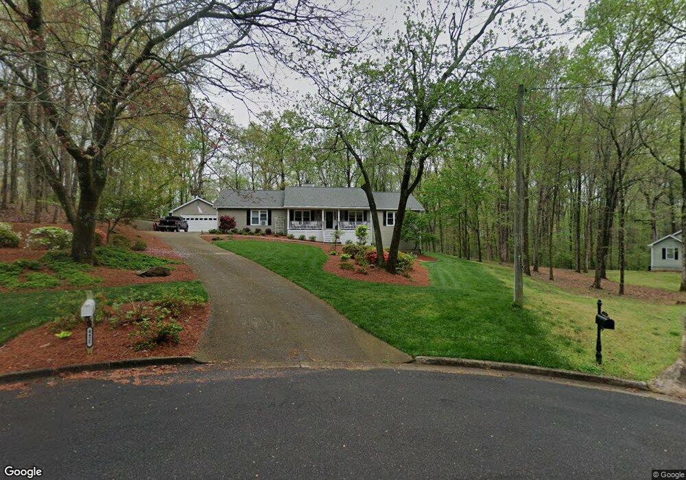
4425 Shaun Ln Cumming, GA 30040
Estimated Value: $471,000 - $534,000
3
Beds
2
Baths
2,034
Sq Ft
$246/Sq Ft
Est. Value
About This Home
This home is located at 4425 Shaun Ln, Cumming, GA 30040 and is currently estimated at $500,083, approximately $245 per square foot. 4425 Shaun Ln is a home located in Forsyth County with nearby schools including Coal Mountain Elementary School, North Forsyth Middle School, and North Forsyth High School.
Ownership History
Date
Name
Owned For
Owner Type
Purchase Details
Closed on
Jun 9, 2003
Sold by
Blowers Randall
Bought by
Blowers Randall A and Blowers Angela
Current Estimated Value
Home Financials for this Owner
Home Financials are based on the most recent Mortgage that was taken out on this home.
Original Mortgage
$185,400
Interest Rate
5.43%
Mortgage Type
New Conventional
Purchase Details
Closed on
Sep 12, 1997
Sold by
Braswell Gail S
Bought by
Blowers Randall
Home Financials for this Owner
Home Financials are based on the most recent Mortgage that was taken out on this home.
Original Mortgage
$139,050
Interest Rate
7.56%
Mortgage Type
VA
Create a Home Valuation Report for This Property
The Home Valuation Report is an in-depth analysis detailing your home's value as well as a comparison with similar homes in the area
Home Values in the Area
Average Home Value in this Area
Purchase History
| Date | Buyer | Sale Price | Title Company |
|---|---|---|---|
| Blowers Randall A | -- | -- | |
| Blowers Randall | $135,000 | -- |
Source: Public Records
Mortgage History
| Date | Status | Borrower | Loan Amount |
|---|---|---|---|
| Closed | Blowers Randall A | $185,400 | |
| Previous Owner | Blowers Randall | $139,050 |
Source: Public Records
Tax History Compared to Growth
Tax History
| Year | Tax Paid | Tax Assessment Tax Assessment Total Assessment is a certain percentage of the fair market value that is determined by local assessors to be the total taxable value of land and additions on the property. | Land | Improvement |
|---|---|---|---|---|
| 2025 | $3,799 | $194,780 | $61,712 | $133,068 |
| 2024 | $3,799 | $186,940 | $57,304 | $129,636 |
| 2023 | $3,179 | $171,608 | $44,080 | $127,528 |
| 2022 | $3,489 | $122,656 | $32,620 | $90,036 |
| 2021 | $3,080 | $122,656 | $32,620 | $90,036 |
| 2020 | $2,996 | $118,580 | $32,620 | $85,960 |
| 2019 | $2,865 | $112,004 | $26,448 | $85,556 |
| 2018 | $2,247 | $86,912 | $24,076 | $62,836 |
| 2017 | $2,085 | $78,832 | $24,320 | $54,512 |
| 2016 | $2,161 | $82,412 | $24,320 | $58,092 |
| 2015 | $2,156 | $81,972 | $21,280 | $60,692 |
| 2014 | $1,820 | $72,028 | $0 | $0 |
Source: Public Records
Map
Nearby Homes
- 6445 Crystal Ln
- 6230 Dana Way
- 7005 Walnut Mill Landing
- 3940 Twin Lakes Rd
- 5925 Water Mark Dr
- 6040 Boulder Bluff Dr
- 7480 Ivy Grove St
- 7620 Ivy Grove St
- 4420 Belcrest Way
- 4905 Rosarian Dr
- 4855 Rosarian Dr
- 4710 Rosarian Dr
- 4115 Sierra Vista Cir
- 4095 Sierra Vista Cir
- 6435 Lakeaires Dr
- 4015 Sierra Vista Cir
- 3415 Spot Rd