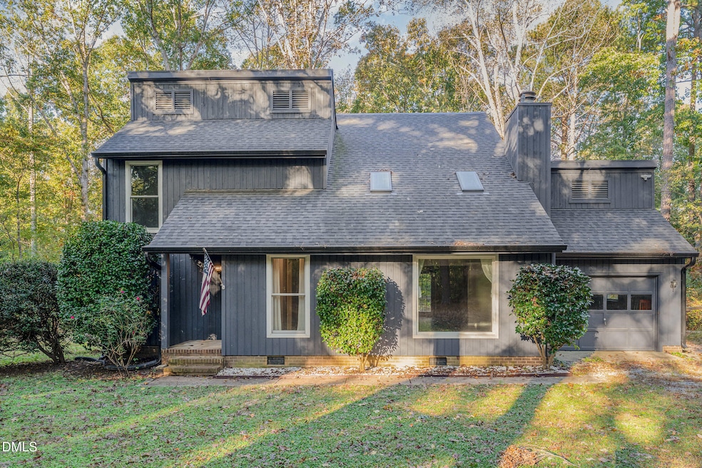
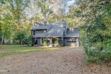

4425 Surry Ridge Cir Apex, NC 27539
Middle Creek NeighborhoodEstimated payment $2,857/month
Highlights
- Very Popular Property
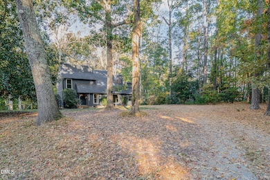
- 0.95 Acre Lot
- Contemporary Architecture
- Middle Creek High Rated A-
- Deck
- Private Lot
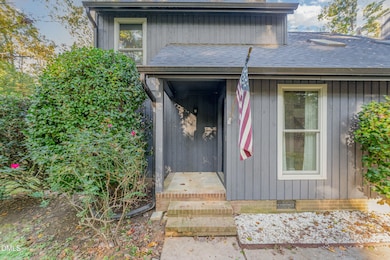
About This Home
NO HOA and NO city taxes! Almost 1 acre lot in Apex. First floor master bedroom! Most of the big items have already been replaced.
HVAC & Ductwork 2021, Anderson windows 2022, roof/gutters/guards 2023, plumbing 2023, water heater 2020. Interior freshly painted. Almost 1 acre with a
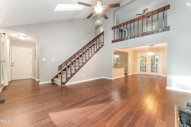
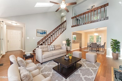
lot of trees for privacy and it's at the end of a cul-de-sac so no traffic! Step inside the home and you are greeted with hardwood flooring on the main level. Vaulted ceilings and a fireplace in the living room open to the kitchen. The kitchen features granite counters, ss appliances, and tons of cabinets! First floor master with en suite bathroom. Bathroom has a walk-in shower with updated tile! Upstairs has two additional bedrooms and a full bath. Outside enjoy the outdoors on the deck overlooking the huge private lot! Feels like being in the country but in the heart of Apex. 25 minutes to RTP, and just a few minutes away from the new 540 southern loop to make travel even easier. There are so many hard to find things in this home! Easy to show, schedule a viewing today!
Home Details
Home Type
- Single Family
Est. Annual Taxes
- $2,718
Year Built
- Built in 1986
Lot Details
- 0.95 Acre Lot
- Private Lot
- Wooded Lot
- Many Trees
Parking
- 1 Car Attached Garage
- 2 Open Parking Spaces
Home Design
- Contemporary Architecture
- Block Foundation
- Architectural Shingle Roof
- Wood Siding
Interior Spaces
- 1,876 Sq Ft Home
- 2-Story Property
- Vaulted Ceiling
- Ceiling Fan
- Wood Burning Fireplace
- Double Pane Windows
- ENERGY STAR Qualified Windows
- Insulated Windows
- Living Room
- Dining Room
- Loft
- Basement
- Crawl Space
- Pull Down Stairs to Attic
- Laundry closet
Kitchen
- Electric Range
- Range Hood
- Dishwasher
- Granite Countertops
Flooring
- Wood
- Carpet
- Tile
Bedrooms and Bathrooms
- 3 Bedrooms | 1 Primary Bedroom on Main
- Walk-In Closet
- Primary bathroom on main floor
Outdoor Features
- Deck
- Rain Gutters
- Front Porch
Schools
- Yates Mill Elementary School
- Dillard Middle School
- Middle Creek High School
Utilities
- Forced Air Heating and Cooling System
- Shared Well
- Septic Tank
- Septic System
Community Details
- No Home Owners Association
- Southwoods Subdivision
Listing and Financial Details
- Assessor Parcel Number 0760.01-25-3495.000
Map
Home Values in the Area
Average Home Value in this Area
Tax History
| Year | Tax Paid | Tax Assessment Tax Assessment Total Assessment is a certain percentage of the fair market value that is determined by local assessors to be the total taxable value of land and additions on the property. | Land | Improvement |
|---|---|---|---|---|
| 2025 | $2,719 | $421,913 | $135,000 | $286,913 |
| 2024 | $2,640 | $421,913 | $135,000 | $286,913 |
| 2023 | $1,998 | $253,681 | $70,000 | $183,681 |
| 2022 | $1,852 | $253,681 | $70,000 | $183,681 |
| 2021 | $1,803 | $253,681 | $70,000 | $183,681 |
| 2020 | $1,773 | $253,681 | $70,000 | $183,681 |
| 2019 | $1,650 | $199,541 | $60,000 | $139,541 |
| 2018 | $1,517 | $199,541 | $60,000 | $139,541 |
| 2017 | $1,439 | $199,541 | $60,000 | $139,541 |
| 2016 | $1,410 | $199,541 | $60,000 | $139,541 |
| 2015 | $1,368 | $194,123 | $54,000 | $140,123 |
| 2014 | -- | $194,123 | $54,000 | $140,123 |
Property History
| Date | Event | Price | List to Sale | Price per Sq Ft |
|---|---|---|---|---|
| 12/08/2025 12/08/25 | Price Changed | $500,000 | -4.8% | $267 / Sq Ft |
| 11/12/2025 11/12/25 | Price Changed | $525,000 | -3.3% | $280 / Sq Ft |
| 11/06/2025 11/06/25 | For Sale | $543,000 | -- | $289 / Sq Ft |
Purchase History
| Date | Type | Sale Price | Title Company |
|---|---|---|---|
| Warranty Deed | $192,000 | None Available |
Mortgage History
| Date | Status | Loan Amount | Loan Type |
|---|---|---|---|
| Open | $182,400 | New Conventional |
Source: Doorify MLS
MLS Number: 10131624
APN: 0760.01-25-3495-000
Disclaimer: Certain information contained herein is derived from information provided by parties other than Homes.com. All information provided is deemed reliable, but is not guaranteed to be accurate and should be independently verified.
![]() Some IDX listings have been excluded from this IDX display. Brokers make an effort to deliver accurate information, but buyers should independently verify any information on which they will rely in a transaction. The listing broker shall not be responsible for any typographical errors, misinformation, or misprints, and they shall be held totally harmless from any damages arising from reliance upon this data. This data is provided exclusively for consumers’ personal, non-commercial use. Listings marked with an icon are provided courtesy of the Doorify MLS, Inc. of North Carolina, Internet Data Exchange Database. Closed (sold) listings may have been listed and/or sold by a real estate firm other than the firm(s) featured on this website. Closed data is not available until the sale of the property is recorded in the MLS. Home sale data is not an appraisal, CMA, competitive or comparative market analysis, or home valuation of any property. Copyright 2025 Doorify MLS, Inc. of North Carolina. All rights reserved.
Some IDX listings have been excluded from this IDX display. Brokers make an effort to deliver accurate information, but buyers should independently verify any information on which they will rely in a transaction. The listing broker shall not be responsible for any typographical errors, misinformation, or misprints, and they shall be held totally harmless from any damages arising from reliance upon this data. This data is provided exclusively for consumers’ personal, non-commercial use. Listings marked with an icon are provided courtesy of the Doorify MLS, Inc. of North Carolina, Internet Data Exchange Database. Closed (sold) listings may have been listed and/or sold by a real estate firm other than the firm(s) featured on this website. Closed data is not available until the sale of the property is recorded in the MLS. Home sale data is not an appraisal, CMA, competitive or comparative market analysis, or home valuation of any property. Copyright 2025 Doorify MLS, Inc. of North Carolina. All rights reserved.
- 3829 Sleepy Brook Ln
- 4104 Belnap Dr
- 1029 Dozier Way
- 4004 Inkberry Ct
- 1023 Augustine Trail
- 3901 Bamburgh Ln
- 116 Vintage Hill Cir
- 1108 Bradshaw Ct
- 1561 Lily Creek Dr
- 3208 Treewood Ln
- 4028 Franks Creek Dr Unit Lot 44
- 229 Shillings Chase Dr
- 4104 Green Chase Way
- 104 Highland Mist Cir
- 8004 Churchill Falls Place
- 222 Shillings Chase Dr
- 112 Sonoma Valley Dr
- 2908 Satori Way
- 208 Bellagio Dr
- 9640 Holly Springs Rd
- 4616 Holly Brook Dr
- 4704 Holly Brook Dr
- 4816 Holly Brook Dr
- 2600 Harvest Creek Place
- 204 Sonoma Valley Dr
- 200 McChesney Hill Loop
- 114 Ransomwood Dr
- 121 Red Bark Ct
- 3304 Drexel Hill Ct
- 2735 Dilly Dally Ct
- 2259 Dr
- 2259 Horton Park Dr
- 114 Gallent Hedge Trail
- 208 Lindell Dr
- 124 Fairford Dr
- 738 Wickham Ridge Rd
- 132 Fountain Springs Rd
- 314 Cabana Dr
- 148 Danesway Dr
- 416 Commons Dr
