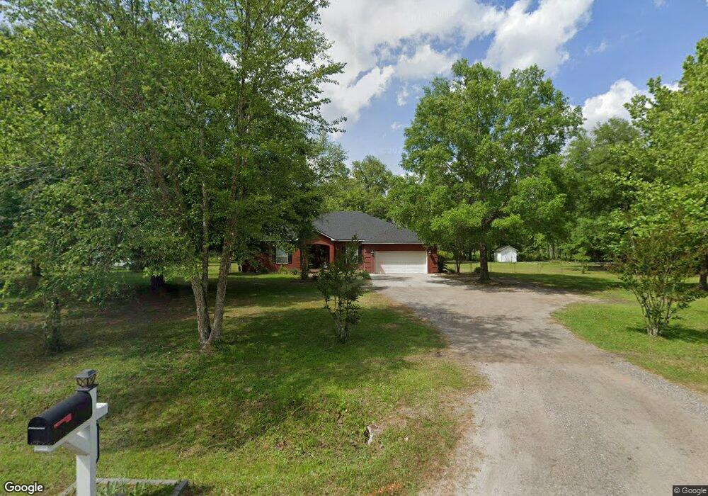
44291 Swallowfork Ave Callahan, FL 32011
Estimated Value: $423,000 - $532,000
3
Beds
3
Baths
3,516
Sq Ft
$142/Sq Ft
Est. Value
About This Home
This home is located at 44291 Swallowfork Ave, Callahan, FL 32011 and is currently estimated at $500,190, approximately $142 per square foot. 44291 Swallowfork Ave is a home located in Nassau County with nearby schools including Callahan Elementary School, Callahan Intermediate School, and Callahan Middle School.
Ownership History
Date
Name
Owned For
Owner Type
Purchase Details
Closed on
Oct 16, 2019
Sold by
Anderson Christie Lynn and Estate Of Carolyn D Arnold
Bought by
Anderson Christie Lynn and Moore Elizabeth Ann
Current Estimated Value
Purchase Details
Closed on
Jul 24, 2000
Sold by
Higginbotham Norwood E
Bought by
Anderson Kenneth S and Anderson Christie L
Home Financials for this Owner
Home Financials are based on the most recent Mortgage that was taken out on this home.
Original Mortgage
$13,500
Interest Rate
10%
Mortgage Type
Seller Take Back
Create a Home Valuation Report for This Property
The Home Valuation Report is an in-depth analysis detailing your home's value as well as a comparison with similar homes in the area
Home Values in the Area
Average Home Value in this Area
Purchase History
| Date | Buyer | Sale Price | Title Company |
|---|---|---|---|
| Anderson Christie Lynn | -- | Attorney | |
| Anderson Kenneth S | $13,500 | -- |
Source: Public Records
Mortgage History
| Date | Status | Borrower | Loan Amount |
|---|---|---|---|
| Previous Owner | Anderson Kenneth S | $13,500 |
Source: Public Records
Tax History Compared to Growth
Tax History
| Year | Tax Paid | Tax Assessment Tax Assessment Total Assessment is a certain percentage of the fair market value that is determined by local assessors to be the total taxable value of land and additions on the property. | Land | Improvement |
|---|---|---|---|---|
| 2024 | $2,490 | $201,751 | -- | -- |
| 2023 | $2,490 | $195,875 | $0 | $0 |
| 2022 | $2,246 | $190,170 | $0 | $0 |
| 2021 | $2,265 | $184,631 | $0 | $0 |
| 2020 | $2,257 | $182,082 | $0 | $0 |
| 2019 | $2,217 | $178,438 | $0 | $0 |
| 2018 | $2,171 | $173,209 | $0 | $0 |
| 2017 | $1,980 | $169,920 | $0 | $0 |
| 2016 | $1,946 | $165,698 | $0 | $0 |
| 2015 | $1,983 | $164,729 | $0 | $0 |
| 2014 | $1,976 | $163,616 | $0 | $0 |
Source: Public Records
Map
Nearby Homes
- 0 Breezy Ln
- 44091 Caulkins Dr
- 44090 Apache Trail
- 45792 Pickett St
- TBD U S 301
- 35110 Gretchens Way
- 45094 Mickler St
- 0 Old Dixie Hwy Unit 2052109
- 35202 Nancy Rd
- 541641 Route 1
- 44025 Woodside Ln
- 0 New Ogilvie Rd Unit 108180
- 0 New Ogilvie Rd
- 45107 Booth St
- 45134 Booth St
- 45112 Second Ave
- 34216 Old Baldwin Rd
- 545819 Route 1
- 0 Lem Turner Rd Unit 110226
- 0 Lem Turner Rd Unit 2056110
- 44339 Swallowfork Ave
- 0 Little Sweetgum Ln Unit 1190213
- 0 Little Sweetgum Ln
- 0 Little Magnolia Ln Unit 940024
- 0 Little Magnolia Ln Unit 940997
- 0 Little Magnolia Ln Unit 937989
- 0 Little Magnolia Ln Unit 1049176
- 0 Little Magnolia Ln Unit 1216104
- 0 Little Magnolia Ln Unit 1216101
- 0 Little Magnolia Ln Unit 1216107
- 0 Little Magnolia Ln Unit 1254211
- 0 Little Magnolia Ln Unit 1254208
- 0 Little Magnolia Ln Unit 1254205
- 0 Little Magnolia Ln Unit 106159
- 0 Little Magnolia Ln Unit 106032
- 0 Little Magnolia Ln Unit 105737
- 0 Little Magnolia Ln
- 44091 Little Sweetgum Ln
- 44355 Swallowfork Ave
- 44203 Swallowfork Ave