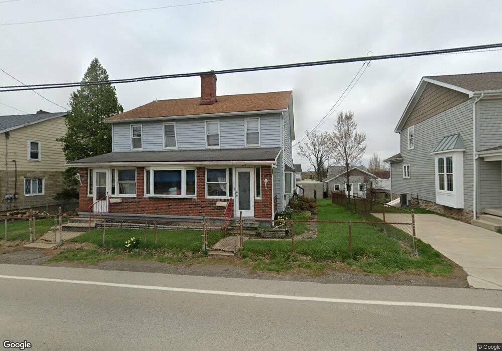
443 Georgetown Rd Lawrence, PA 15055
Estimated Value: $89,848 - $115,000
4
Beds
2
Baths
2,370
Sq Ft
$41/Sq Ft
Est. Value
About This Home
This home is located at 443 Georgetown Rd, Lawrence, PA 15055 and is currently estimated at $97,462, approximately $41 per square foot. 443 Georgetown Rd is a home with nearby schools including Canon-Mcmillan Senior High School and St. Louise De Marillac School.
Ownership History
Date
Name
Owned For
Owner Type
Purchase Details
Closed on
Jul 31, 2025
Sold by
Swzp Real Estate Llc
Bought by
Perrell Eric Jon and Perrell Carrie Jean
Current Estimated Value
Purchase Details
Closed on
Aug 27, 2024
Sold by
Howcroft Salina Nicole and Burgh Eric R
Bought by
Swzp Real Estate Llc
Home Financials for this Owner
Home Financials are based on the most recent Mortgage that was taken out on this home.
Original Mortgage
$49,000
Interest Rate
8.63%
Mortgage Type
New Conventional
Create a Home Valuation Report for This Property
The Home Valuation Report is an in-depth analysis detailing your home's value as well as a comparison with similar homes in the area
Home Values in the Area
Average Home Value in this Area
Purchase History
| Date | Buyer | Sale Price | Title Company |
|---|---|---|---|
| Perrell Eric Jon | $90,000 | None Listed On Document | |
| Swzp Real Estate Llc | $70,000 | None Listed On Document |
Source: Public Records
Mortgage History
| Date | Status | Borrower | Loan Amount |
|---|---|---|---|
| Previous Owner | Swzp Real Estate Llc | $49,000 |
Source: Public Records
Tax History Compared to Growth
Tax History
| Year | Tax Paid | Tax Assessment Tax Assessment Total Assessment is a certain percentage of the fair market value that is determined by local assessors to be the total taxable value of land and additions on the property. | Land | Improvement |
|---|---|---|---|---|
| 2025 | $1,729 | $102,700 | $22,800 | $79,900 |
| 2024 | $1,636 | $102,700 | $22,800 | $79,900 |
| 2023 | $1,636 | $102,700 | $22,800 | $79,900 |
| 2022 | $1,631 | $102,700 | $22,800 | $79,900 |
| 2021 | $1,631 | $102,700 | $22,800 | $79,900 |
| 2020 | $1,600 | $102,700 | $22,800 | $79,900 |
| 2019 | $1,574 | $102,700 | $22,800 | $79,900 |
| 2018 | $1,543 | $102,700 | $22,800 | $79,900 |
| 2017 | $283 | $102,700 | $22,800 | $79,900 |
| 2016 | $283 | $11,372 | $1,418 | $9,954 |
| 2015 | $231 | $11,372 | $1,418 | $9,954 |
| 2014 | $283 | $11,372 | $1,418 | $9,954 |
| 2013 | $283 | $11,372 | $1,418 | $9,954 |
Source: Public Records
Map
Nearby Homes
- 16 School St
- 138 Driftwood Dr
- 121 Anglers Way
- 251 Molly Dr
- 1033 Rutledge Dr
- 0 Park Dr
- 369 Maple Ln
- 2657 Bingham Dr
- 1271 Redfern Dr
- LOT 2 Boyce Rd
- 1049 Boyce Rd
- 140 Maple Ln
- Lot 79-12 Baker Rd
- 700 Circle Dr
- [Lot 740] 1420 Hollow Tree Dr
- 1661 Hollow Tree Dr
- 1651 Hollow Tree Dr
- [Lot 708] 1291 Redfern Dr
- 109 Sherborne Dr
- 9504 Sundance Dr
- 439 Georgetown Rd Unit 439
- 439 Georgetown Rd Unit 437
- 449 Georgetown Rd
- 453 Georgetown Rd
- 432 Georgetown Rd
- 431 Georgetown Rd
- 364 1st St
- 362 1st St
- 358 1st St
- 457 Georgetown Rd
- 356 1st St
- 450 Georgetown Rd
- 376 1st St
- 463 Georgetown Rd
- 421 Georgetown Rd
- 363 1st St
- 369 1st St
- 89 First St
- 375 1st St
- 355 1st St