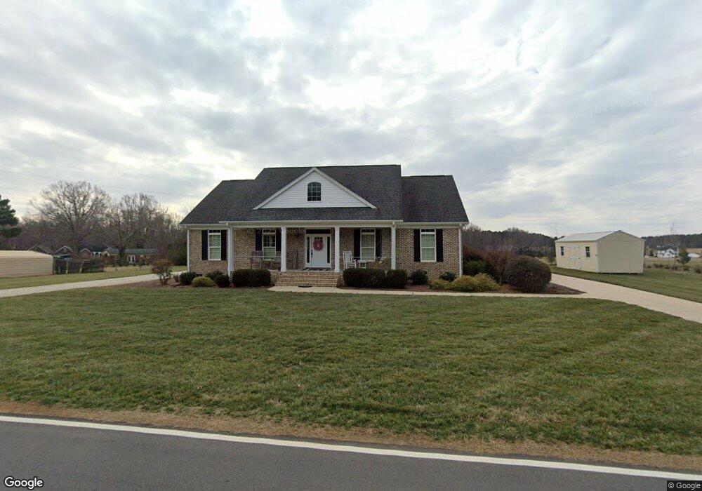
443 Maynard Grayson Rd Clover, SC 29710
Estimated Value: $328,000 - $512,000
Studio
--
Bath
1,925
Sq Ft
$218/Sq Ft
Est. Value
About This Home
This home is located at 443 Maynard Grayson Rd, Clover, SC 29710 and is currently estimated at $420,185, approximately $218 per square foot. 443 Maynard Grayson Rd is a home located in York County with nearby schools including Bethany Elementary School, Clover Middle School, and Clover High School.
Ownership History
Date
Name
Owned For
Owner Type
Purchase Details
Closed on
Feb 16, 2021
Sold by
Dickerson Lori R
Bought by
Dickerson Lori R and Dickerson Lori R
Current Estimated Value
Purchase Details
Closed on
Mar 16, 2017
Sold by
Estate Of Frances Mae Ford Robinson
Bought by
Jenkins Elizabeth R and Ledford Debra R
Purchase Details
Closed on
Mar 14, 2017
Sold by
Robinson Thomas B and Robinson James N
Bought by
Dickerson Lori R
Purchase Details
Closed on
May 13, 2009
Sold by
Hailey Steven Mark and Riese Rick T
Bought by
Wilson Caleb Joel and Wilson Sheena Stewart
Create a Home Valuation Report for This Property
The Home Valuation Report is an in-depth analysis detailing your home's value as well as a comparison with similar homes in the area
Home Values in the Area
Average Home Value in this Area
Purchase History
| Date | Buyer | Sale Price | Title Company |
|---|---|---|---|
| Dickerson Lori R | -- | None Available | |
| Jenkins Elizabeth R | -- | None Available | |
| Dickerson Lori R | -- | None Available | |
| Wilson Caleb Joel | $179,900 | -- |
Source: Public Records
Tax History Compared to Growth
Tax History
| Year | Tax Paid | Tax Assessment Tax Assessment Total Assessment is a certain percentage of the fair market value that is determined by local assessors to be the total taxable value of land and additions on the property. | Land | Improvement |
|---|---|---|---|---|
| 2025 | $1,752 | $13,947 | $1,206 | $12,741 |
| 2024 | $1,571 | $12,128 | $800 | $11,328 |
| 2023 | $1,614 | $12,127 | $800 | $11,327 |
| 2022 | $1,305 | $12,127 | $800 | $11,327 |
| 2021 | -- | $12,127 | $800 | $11,327 |
| 2020 | $1,283 | $12,127 | $0 | $0 |
| 2019 | $1,322 | $11,388 | $0 | $0 |
| 2018 | $310 | $11,388 | $0 | $0 |
| 2017 | $1,047 | $3,180 | $0 | $0 |
| 2016 | $1,021 | $3,180 | $0 | $0 |
| 2014 | $22 | $2,120 | $600 | $1,520 |
| 2013 | $22 | $2,200 | $600 | $1,600 |
Source: Public Records
Map
Nearby Homes
- 00 Tart Rd
- 12795 Highway 55 W
- 3134 Ranger Rd
- 1240 Beamguard Rd
- 2944 Ranger Rd
- 946 Laurelwood Dr
- TBD Crossland Rd Unit 2
- 218 Muldoon Ln
- 226 Muldoon Ln
- 1994 Greenleaf Rd
- 290 S Grandview Rd
- 0000 Davis Cir
- 00 State Road S-46-883
- 522 Whitworth Rd
- Crossland Road Unit: 2
- 1312 Sage Pine Cir Unit 19
- Lot 1 Rhyne Rd
- 13546 State Highway 55
- 5264 Battleground Rd
- 1069 Sage Pine Cir
- 465 Maynard Grayson Rd
- 447 Maynard Grayson Rd
- 1511 Carroll Falls Rd
- 455 Maynard Grayson Rd
- 476 Maynard Grayson Rd
- 444 Maynard Grayson Rd
- Lot A Maynard Grayson Rd
- 479 Maynard Grayson Rd
- 395 Maynard Grayson Rd
- 2961 Highway 55 W
- 2963 Highway 55 W
- 3003 Highway 55 W
- Tract #A Maynard Grayson Rd
- 2945 Highway 55 W
- 354 Maynard Grayson Rd
- 2931 Highway 55 W
- 2991 Highway 55 W
- 526 Maynard Grayson Rd
- 13 +/- AC Maynard Grayson Rd
- 6.5 ac Hwy 55 Hwy