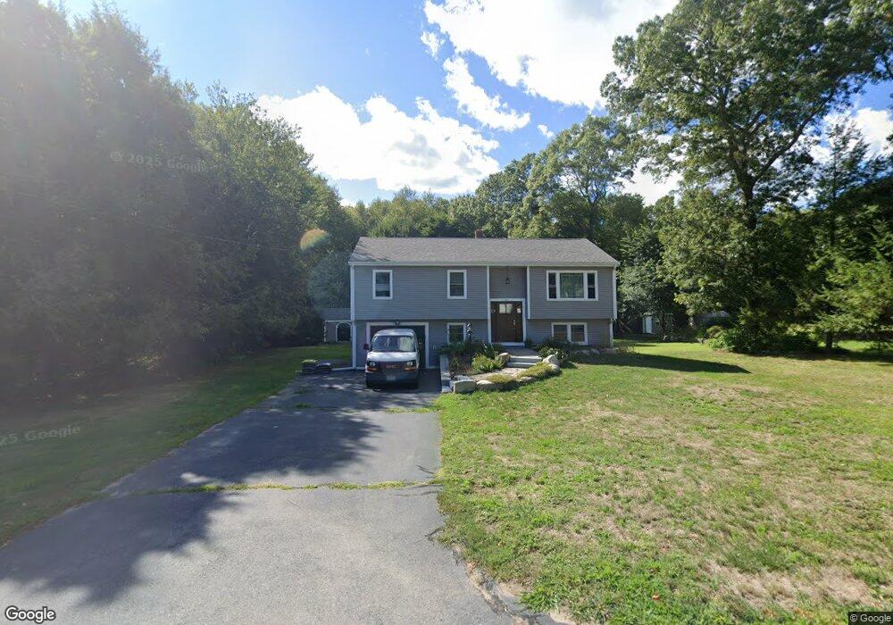
444 Forest St North Dighton, MA 02764
Estimated Value: $483,000 - $545,000
3
Beds
2
Baths
1,106
Sq Ft
$456/Sq Ft
Est. Value
About This Home
This home is located at 444 Forest St, North Dighton, MA 02764 and is currently estimated at $504,716, approximately $456 per square foot. 444 Forest St is a home located in Bristol County with nearby schools including Dighton-Rehoboth Regional High School and Our Lady of Lourdes School.
Ownership History
Date
Name
Owned For
Owner Type
Purchase Details
Closed on
Sep 30, 1996
Sold by
Ferreira Raymond P and Ferreira Debroah L
Bought by
Dooley Timothy P
Current Estimated Value
Home Financials for this Owner
Home Financials are based on the most recent Mortgage that was taken out on this home.
Original Mortgage
$104,000
Outstanding Balance
$9,329
Interest Rate
7.83%
Mortgage Type
Purchase Money Mortgage
Estimated Equity
$495,387
Create a Home Valuation Report for This Property
The Home Valuation Report is an in-depth analysis detailing your home's value as well as a comparison with similar homes in the area
Home Values in the Area
Average Home Value in this Area
Purchase History
| Date | Buyer | Sale Price | Title Company |
|---|---|---|---|
| Dooley Timothy P | $139,000 | -- |
Source: Public Records
Mortgage History
| Date | Status | Borrower | Loan Amount |
|---|---|---|---|
| Open | Dooley Timothy P | $104,000 | |
| Previous Owner | Dooley Timothy P | $20,000 | |
| Previous Owner | Dooley Timothy P | $10,000 | |
| Previous Owner | Dooley Timothy P | $88,000 |
Source: Public Records
Tax History Compared to Growth
Tax History
| Year | Tax Paid | Tax Assessment Tax Assessment Total Assessment is a certain percentage of the fair market value that is determined by local assessors to be the total taxable value of land and additions on the property. | Land | Improvement |
|---|---|---|---|---|
| 2025 | $4,831 | $384,600 | $137,800 | $246,800 |
| 2024 | $4,814 | $351,900 | $136,300 | $215,600 |
| 2023 | $4,599 | $329,900 | $136,300 | $193,600 |
| 2022 | $4,437 | $310,500 | $132,800 | $177,700 |
| 2021 | $4,198 | $283,100 | $120,100 | $163,000 |
| 2020 | $4,214 | $281,300 | $134,100 | $147,200 |
| 2019 | $4,100 | $273,500 | $134,100 | $139,400 |
| 2018 | $0 | $252,200 | $114,000 | $138,200 |
| 2017 | $3,675 | $246,000 | $132,300 | $113,700 |
| 2016 | $3,690 | $242,300 | $136,300 | $106,000 |
| 2015 | $3,644 | $246,200 | $140,200 | $106,000 |
| 2014 | $3,655 | $240,000 | $140,200 | $99,800 |
Source: Public Records
Map
Nearby Homes
- 810 Tremont St
- 343 Forest St
- 698 School St Unit 698
- 876 Autumn St
- 233-R Summer St
- 0 Summer St
- 238 Andrews St
- 0 Andrews St
- 1401 Tremont St
- 1421 Tremont St
- 593 Williams St
- 0 Monteiro Unit 71870472
- 1565 Maple St
- 301 Williams St
- 7 Maris Ln
- 36 Maynard Unit A
- 240 Country Hill Dr
- 1680 Maple St
- 1438 Somerset Ave
- 1472 Somerset Ave