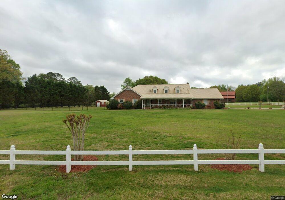
444 Greenfield Rd Hiram, GA 30141
East Paulding County NeighborhoodEstimated Value: $550,000 - $601,000
4
Beds
2
Baths
3,594
Sq Ft
$158/Sq Ft
Est. Value
About This Home
This home is located at 444 Greenfield Rd, Hiram, GA 30141 and is currently estimated at $568,962, approximately $158 per square foot. 444 Greenfield Rd is a home located in Paulding County with nearby schools including Hiram Elementary School, P. B. Ritch Middle School, and East Paulding High School.
Ownership History
Date
Name
Owned For
Owner Type
Purchase Details
Closed on
Sep 15, 2009
Sold by
Burger Lee
Bought by
Norton Kenith E and Norton Debra D
Current Estimated Value
Home Financials for this Owner
Home Financials are based on the most recent Mortgage that was taken out on this home.
Original Mortgage
$403,644
Outstanding Balance
$262,772
Interest Rate
5.1%
Mortgage Type
VA
Estimated Equity
$306,190
Purchase Details
Closed on
Nov 22, 2004
Sold by
Braswell Charles B and Braswell Robbie
Bought by
Burger Lee
Create a Home Valuation Report for This Property
The Home Valuation Report is an in-depth analysis detailing your home's value as well as a comparison with similar homes in the area
Home Values in the Area
Average Home Value in this Area
Purchase History
| Date | Buyer | Sale Price | Title Company |
|---|---|---|---|
| Norton Kenith E | $390,800 | -- | |
| Burger Lee | $200,000 | -- |
Source: Public Records
Mortgage History
| Date | Status | Borrower | Loan Amount |
|---|---|---|---|
| Open | Norton Kenith E | $403,644 |
Source: Public Records
Tax History Compared to Growth
Tax History
| Year | Tax Paid | Tax Assessment Tax Assessment Total Assessment is a certain percentage of the fair market value that is determined by local assessors to be the total taxable value of land and additions on the property. | Land | Improvement |
|---|---|---|---|---|
| 2024 | $1,639 | $236,248 | $23,120 | $213,128 |
| 2023 | $1,739 | $215,076 | $22,000 | $193,076 |
| 2022 | $3,119 | $188,504 | $18,440 | $170,064 |
| 2021 | $2,749 | $146,512 | $15,560 | $130,952 |
| 2020 | $2,449 | $127,240 | $14,800 | $112,440 |
| 2019 | $2,332 | $119,060 | $13,320 | $105,740 |
| 2018 | $3,606 | $119,696 | $12,720 | $106,976 |
| 2017 | $3,330 | $109,004 | $12,200 | $96,804 |
| 2016 | $2,607 | $86,208 | $12,200 | $74,008 |
| 2015 | $2,507 | $81,448 | $11,960 | $69,488 |
| 2014 | $2,310 | $73,168 | $11,000 | $62,168 |
| 2013 | -- | $65,520 | $12,160 | $53,360 |
Source: Public Records
Map
Nearby Homes
- 1625 Lake Rd
- 4622 MacLand Rd
- 4624 MacLand Rd
- 109 Darbys Crossing Ct
- 184 Darbys Crossing Ct
- 35 Pinewood Ct
- 1261 Silvercrest Ct SW
- 290 Harvest Trail
- 295 Hiram Acworth Hwy
- 1520 Silver Mist Cir
- 244 Rosedale Dr
- 119 English Barn Way
- 80 Indian Lake Dr
- 225 Harvest Trail
- 132 English Barn Way
- 142 English Barn Way
- 20 Weathervane Way
- 152 English Barn Way
- 162 English Barn Way
- 150 Hiram Terrace