Estimated Value: $247,231 - $278,000
4
Beds
2
Baths
1,504
Sq Ft
$174/Sq Ft
Est. Value
About This Home
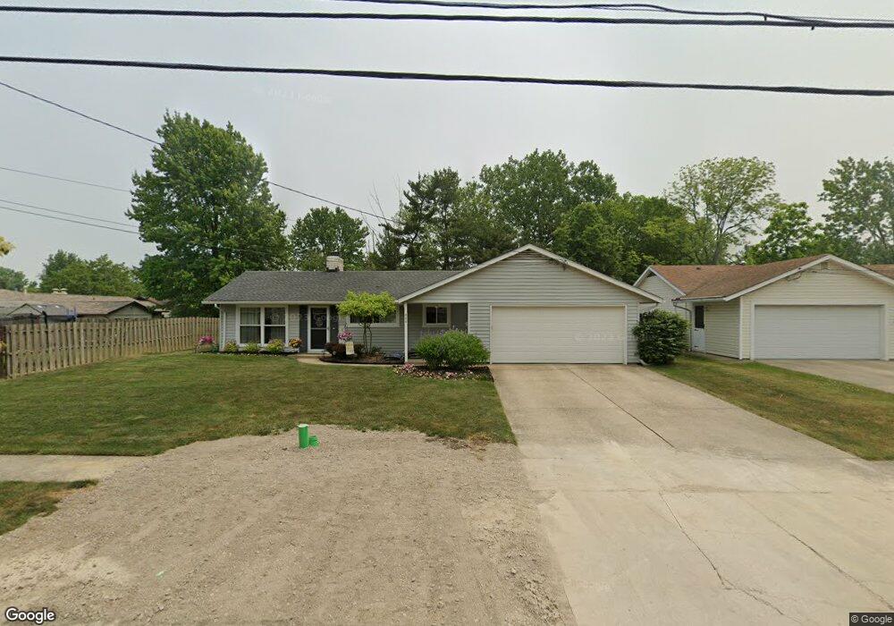
This home is located at 444 Maple Ave, Berea, OH 44017 and is currently estimated at $262,308, approximately $174 per square foot. 444 Maple Ave is a home located in Cuyahoga County with nearby schools including Grindstone Elementary School, Berea-Midpark Middle School, and Berea-Midpark High School.
Ownership History
Date
Name
Owned For
Owner Type
Purchase Details
Closed on
Aug 9, 2011
Sold by
Ruple Kevin P
Bought by
Bell Deedee
Current Estimated Value
Home Financials for this Owner
Home Financials are based on the most recent Mortgage that was taken out on this home.
Original Mortgage
$108,171
Interest Rate
4.25%
Mortgage Type
FHA
Purchase Details
Closed on
Oct 31, 1995
Sold by
Trst Jean B Nicholson
Bought by
Ruple Kevin P and Bell Dee Dee
Home Financials for this Owner
Home Financials are based on the most recent Mortgage that was taken out on this home.
Original Mortgage
$88,200
Interest Rate
7.65%
Mortgage Type
New Conventional
Purchase Details
Closed on
May 7, 1993
Bought by
Gruss Joyce Ann, Trustee
Purchase Details
Closed on
Mar 9, 1993
Sold by
Nicholson David B and Nicholson Jean B
Bought by
Nicholson Jean B Trustee
Purchase Details
Closed on
Jan 1, 1975
Bought by
Nicholson David B and Nicholson Jean B
Create a Home Valuation Report for This Property
The Home Valuation Report is an in-depth analysis detailing your home's value as well as a comparison with similar homes in the area
Home Values in the Area
Average Home Value in this Area
Purchase History
| Date | Buyer | Sale Price | Title Company |
|---|---|---|---|
| Bell Deedee | -- | Public | |
| Ruple Kevin P | $98,000 | -- | |
| Gruss Joyce Ann, Trustee | -- | -- | |
| Nicholson Jean B Trustee | -- | -- | |
| Nicholson David B | -- | -- |
Source: Public Records
Mortgage History
| Date | Status | Borrower | Loan Amount |
|---|---|---|---|
| Previous Owner | Bell Deedee | $108,171 | |
| Previous Owner | Ruple Kevin P | $88,200 |
Source: Public Records
Tax History
| Year | Tax Paid | Tax Assessment Tax Assessment Total Assessment is a certain percentage of the fair market value that is determined by local assessors to be the total taxable value of land and additions on the property. | Land | Improvement |
|---|---|---|---|---|
| 2024 | $4,377 | $75,705 | $15,820 | $59,885 |
| 2023 | $3,798 | $54,990 | $11,450 | $43,540 |
| 2022 | $3,774 | $54,985 | $11,445 | $43,540 |
| 2021 | $3,742 | $54,990 | $11,450 | $43,540 |
| 2020 | $3,574 | $46,590 | $9,700 | $36,890 |
| 2019 | $3,478 | $133,100 | $27,700 | $105,400 |
| 2018 | $3,229 | $46,590 | $9,700 | $36,890 |
| 2017 | $3,220 | $40,250 | $8,330 | $31,920 |
| 2016 | $3,197 | $40,250 | $8,330 | $31,920 |
| 2015 | $3,147 | $40,250 | $8,330 | $31,920 |
| 2014 | $3,147 | $41,930 | $8,680 | $33,250 |
Source: Public Records
Map
Nearby Homes
- 56 3rd Ave
- 0 E Bagley Rd Unit 5111166
- 41 W 5th Ave
- 93 W 5th Ave
- 445 Berea St
- 725 Shakespeare Dr
- 57 Riverside Dr
- 487 Karen Dr
- 211 W Bridge St
- 47 Prospect St
- 6574 Burton Dr
- 209 Gibson St
- 146 Marian Ln
- 160 Marian Ln Unit 6A
- 49 Monroe St
- 216 Kraft St
- 275 Quarrystone Ln
- 428 Park Place
- 6490 Grosse Dr
- 7400 Engle Rd
- 436 Maple Ave
- 454 Maple Ave
- 178 Barberry Dr
- 430 Maple Ave
- 443 Woodlawn Cir
- 435 Woodlawn Cir
- 186 Barberry Dr
- 453 Maple Ave
- 58 Barberry Dr
- 443 Maple Ave
- 422 Maple Ave
- 427 Woodlawn Cir
- 194 Barberry Dr
- 148 Barberry Dr
- 66 Barberry Dr
- 419 Woodlawn Cir
- 414 Maple Ave
- 169 Barberry Dr
- 177 Barberry Dr
- 163 Barberry Dr
Your Personal Tour Guide
Ask me questions while you tour the home.