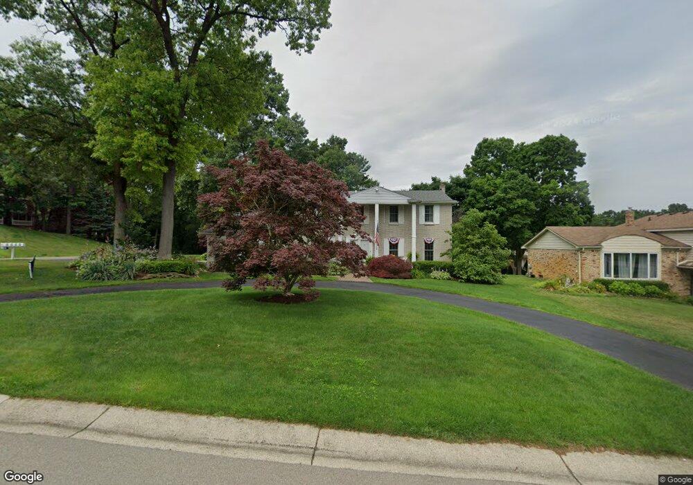
444 Melinda Cir E White Lake, MI 48386
Estimated Value: $415,308 - $449,000
4
Beds
3
Baths
2,434
Sq Ft
$178/Sq Ft
Est. Value
About This Home
This home is located at 444 Melinda Cir E, White Lake, MI 48386 and is currently estimated at $432,327, approximately $177 per square foot. 444 Melinda Cir E is a home located in Oakland County with nearby schools including Clifford H. Smart Middle School, Walled Lake Northern High School, and Lakecrest Baptist School.
Ownership History
Date
Name
Owned For
Owner Type
Purchase Details
Closed on
Aug 27, 2003
Sold by
Picking Jacqueline Ann
Bought by
Cortes Karrie and Cortes Oemil
Current Estimated Value
Purchase Details
Closed on
Mar 21, 2002
Sold by
Picking David R
Bought by
Picking Jacqueline A
Purchase Details
Closed on
Sep 18, 1995
Sold by
Picking David R
Bought by
Picking David R
Home Financials for this Owner
Home Financials are based on the most recent Mortgage that was taken out on this home.
Original Mortgage
$131,900
Interest Rate
7.43%
Create a Home Valuation Report for This Property
The Home Valuation Report is an in-depth analysis detailing your home's value as well as a comparison with similar homes in the area
Home Values in the Area
Average Home Value in this Area
Purchase History
| Date | Buyer | Sale Price | Title Company |
|---|---|---|---|
| Cortes Karrie | $250,000 | Title One Inc | |
| Picking Jacqueline A | $22,500 | -- | |
| Picking David R | -- | -- |
Source: Public Records
Mortgage History
| Date | Status | Borrower | Loan Amount |
|---|---|---|---|
| Previous Owner | Picking David R | $131,900 |
Source: Public Records
Tax History Compared to Growth
Tax History
| Year | Tax Paid | Tax Assessment Tax Assessment Total Assessment is a certain percentage of the fair market value that is determined by local assessors to be the total taxable value of land and additions on the property. | Land | Improvement |
|---|---|---|---|---|
| 2024 | $1,957 | $185,230 | $0 | $0 |
| 2023 | $1,845 | $163,720 | $0 | $0 |
| 2022 | $5,158 | $156,770 | $0 | $0 |
| 2021 | $4,973 | $146,230 | $0 | $0 |
| 2020 | $1,824 | $146,260 | $0 | $0 |
| 2019 | $3,534 | $135,020 | $0 | $0 |
| 2018 | $3,212 | $127,540 | $0 | $0 |
| 2017 | $3,424 | $127,540 | $0 | $0 |
| 2016 | $3,236 | $124,280 | $0 | $0 |
| 2015 | -- | $115,090 | $0 | $0 |
| 2014 | -- | $99,030 | $0 | $0 |
| 2011 | -- | $82,850 | $0 | $0 |
Source: Public Records
Map
Nearby Homes
- 8341 Sharon Dr
- 8110 High Point Trail
- 193 Coppice Way
- 8165 Sequoia Ln Unit 92
- 8363 Capstone Dr
- 8637 Brazos Ct
- 8962 Glasgow Dr
- 165 Lisa Ct
- 8993 Haymarket St
- 229 Summit Ridge
- 0000 Williams Lake Rd
- 121 Allen Lake Dr
- 00 Fox Bay Dr
- 785 Akehurst Ln
- 700 Ander Ln Unit 88
- 00 Union Lake Rd
- 837 Preserve Ln
- 000 Sandycrest Dr
- 7971 Turrillium Ln
- 8650 Sandy Crest Dr
- 424 Melinda Cir E
- 439 Melinda Cir
- 421 Melinda Cir
- 441 Melinda Cir E
- 404 Melinda Cir E
- 455 Melinda Cir E
- 494 Melinda Cir
- 415 Melinda Cir E
- 403 Melinda Cir
- 480 Melinda Cir
- 481 Melinda Cir E
- 392 Melinda Cir E Unit Bldg-Unit
- 392 Melinda Cir E
- 469 Melinda Cir E
- 466 Melinda Cir
- 432 Melinda Cir
- 385 Melinda Cir
- 450 Melinda Cir
- 395 Melinda Cir E
- 414 Melinda Cir