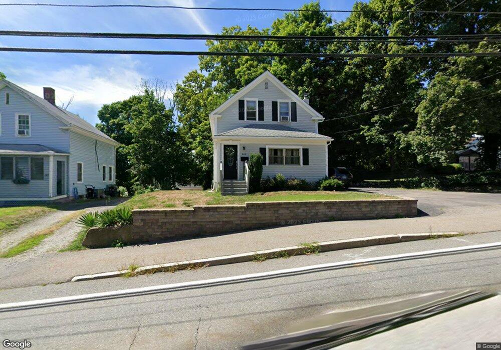
444 N Washington St North Attleboro, MA 02760
North Attleboro NeighborhoodEstimated Value: $329,000 - $416,000
3
Beds
2
Baths
660
Sq Ft
$554/Sq Ft
Est. Value
About This Home
This home is located at 444 N Washington St, North Attleboro, MA 02760 and is currently estimated at $365,660, approximately $554 per square foot. 444 N Washington St is a home located in Bristol County with nearby schools including North Attleboro High School and Cadence Academy Preschool - North Attleborough.
Ownership History
Date
Name
Owned For
Owner Type
Purchase Details
Closed on
Jun 17, 2025
Sold by
Meaney Diane M and Meaney Steven P
Bought by
Meaney Steven P
Current Estimated Value
Purchase Details
Closed on
Jan 1, 1986
Bought by
Meaney Steven P and Meaney Diane M
Create a Home Valuation Report for This Property
The Home Valuation Report is an in-depth analysis detailing your home's value as well as a comparison with similar homes in the area
Home Values in the Area
Average Home Value in this Area
Purchase History
| Date | Buyer | Sale Price | Title Company |
|---|---|---|---|
| Meaney Steven P | -- | None Available | |
| Meaney Steven P | -- | None Available | |
| Meaney Steven P | -- | -- |
Source: Public Records
Mortgage History
| Date | Status | Borrower | Loan Amount |
|---|---|---|---|
| Previous Owner | Meaney Steven P | $81,000 | |
| Previous Owner | Meaney Steven P | $30,000 | |
| Previous Owner | Meaney Steven P | $80,000 |
Source: Public Records
Tax History Compared to Growth
Tax History
| Year | Tax Paid | Tax Assessment Tax Assessment Total Assessment is a certain percentage of the fair market value that is determined by local assessors to be the total taxable value of land and additions on the property. | Land | Improvement |
|---|---|---|---|---|
| 2025 | $3,416 | $289,700 | $105,000 | $184,700 |
| 2024 | $3,265 | $282,900 | $105,000 | $177,900 |
| 2023 | $3,276 | $256,100 | $105,000 | $151,100 |
| 2022 | $3,212 | $230,600 | $99,700 | $130,900 |
| 2021 | $0 | $229,200 | $94,500 | $134,700 |
| 2020 | $3,166 | $220,600 | $89,200 | $131,400 |
| 2019 | $2,948 | $207,000 | $81,100 | $125,900 |
| 2018 | $5,257 | $191,300 | $76,300 | $115,000 |
| 2017 | $2,321 | $175,600 | $71,600 | $104,000 |
| 2016 | $2,390 | $180,800 | $95,400 | $85,400 |
| 2015 | $2,231 | $169,800 | $95,400 | $74,400 |
| 2014 | $2,273 | $171,700 | $89,600 | $82,100 |
Source: Public Records
Map
Nearby Homes
- 35-R Whiting St
- 45 Moran St
- 64 Smith St
- 2 Franklin Ave
- 271 N Washington St
- 34 Hawthorne St
- 194 Smith St
- 157 Fisher St
- 39 Columbia St
- 633 E Washington St Unit 17
- 835 Mt Hope St Unit 39
- 68 N Washington St Unit 210
- 19 Church St Unit C9
- 0 Landry 2nd Unit 73350867
- 12 Houde St
- 29 Broad St
- 16 Richards Ave Unit 106
- 93 Bank St
- 19 Valerie Dr
- 711 Mount Hope St Unit 13
- 440 N Washington St
- 436 N Washington St
- 436 N Washington St
- 436 N Washington St Unit 1
- 454 N Washington St Unit 456
- 199 Park St
- 193 Park St
- 432 N Washington St
- 179 Park St Unit 1
- 437 N Washington St
- 437 N Washington St Unit R
- 437 N Washington St
- 437 N Washington St Unit 2
- 437 N Washington St Unit 1
- 426 N Washington St
- 426 N Washington St Unit 2
- 207 Park St Unit 1
- 207 Park St
- 460 N Washington St
- 424 N Washington St