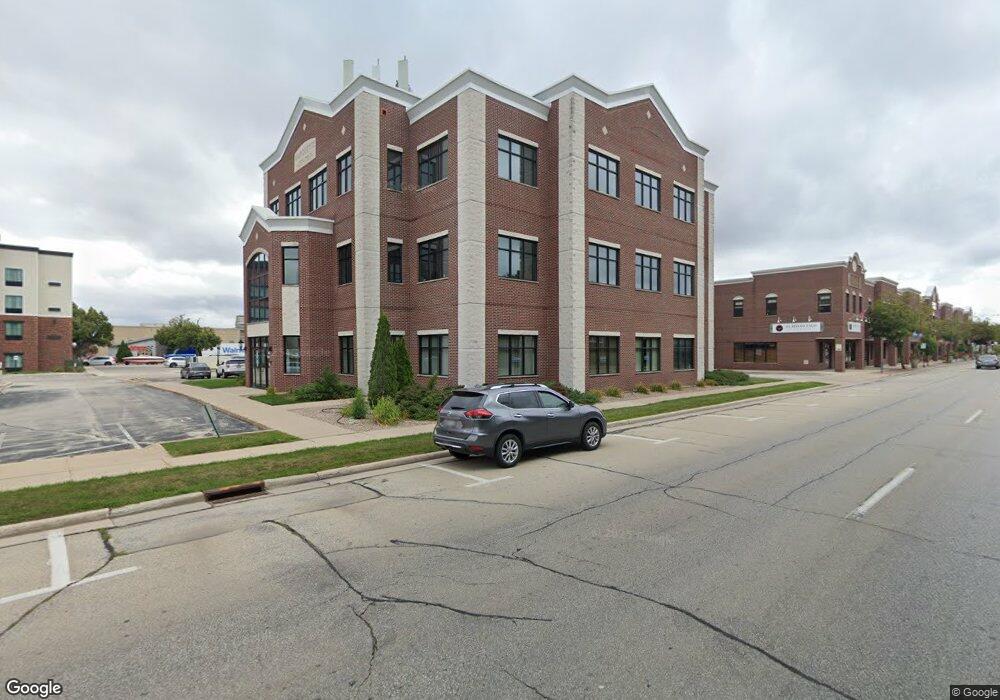
444 Reid St de Pere, WI 54115
Estimated Value: $3,593,627
--
Bed
--
Bath
19,784
Sq Ft
$182/Sq Ft
Est. Value
About This Home
This home is located at 444 Reid St, de Pere, WI 54115 and is currently estimated at $3,593,627, approximately $181 per square foot. 444 Reid St is a home located in Brown County with nearby schools including Westwood Elementary School, West De Pere Middle School, and West De Pere High School.
Ownership History
Date
Name
Owned For
Owner Type
Purchase Details
Closed on
Jun 10, 2022
Sold by
Park Place Holdings - Reid Street Llc
Bought by
City Of De Pere
Current Estimated Value
Purchase Details
Closed on
Feb 15, 2018
Sold by
Marquette Centre Llc
Bought by
Park Place Holdings Reid Street Llc
Home Financials for this Owner
Home Financials are based on the most recent Mortgage that was taken out on this home.
Original Mortgage
$1,900,000
Interest Rate
3.95%
Mortgage Type
Commercial
Purchase Details
Closed on
May 31, 2001
Sold by
The City De Pere Redevelopment Authority
Bought by
Marquette Centre Llc
Create a Home Valuation Report for This Property
The Home Valuation Report is an in-depth analysis detailing your home's value as well as a comparison with similar homes in the area
Home Values in the Area
Average Home Value in this Area
Purchase History
| Date | Buyer | Sale Price | Title Company |
|---|---|---|---|
| City Of De Pere | -- | -- | |
| Park Place Holdings Reid Street Llc | $1,900,000 | Dominion Title & Exchange Se | |
| Marquette Centre Llc | -- | -- | |
| The City De Pere Redevelopment Authority | -- | -- |
Source: Public Records
Mortgage History
| Date | Status | Borrower | Loan Amount |
|---|---|---|---|
| Previous Owner | Park Place Holdings Reid Street Llc | $1,900,000 |
Source: Public Records
Tax History Compared to Growth
Tax History
| Year | Tax Paid | Tax Assessment Tax Assessment Total Assessment is a certain percentage of the fair market value that is determined by local assessors to be the total taxable value of land and additions on the property. | Land | Improvement |
|---|---|---|---|---|
| 2024 | $34,797 | $2,070,000 | $265,300 | $1,804,700 |
| 2023 | $31,754 | $1,800,000 | $265,300 | $1,534,700 |
| 2022 | $36,630 | $1,900,000 | $281,000 | $1,619,000 |
| 2021 | $38,719 | $1,900,000 | $281,000 | $1,619,000 |
| 2020 | $40,919 | $1,900,000 | $281,000 | $1,619,000 |
| 2019 | $40,739 | $1,900,000 | $281,000 | $1,619,000 |
| 2018 | $45,733 | $2,089,100 | $281,000 | $1,808,100 |
| 2017 | $46,611 | $2,089,100 | $281,000 | $1,808,100 |
| 2016 | $46,931 | $2,089,100 | $281,000 | $1,808,100 |
| 2015 | $52,018 | $2,280,700 | $281,000 | $1,999,700 |
| 2014 | $51,456 | $2,280,700 | $281,000 | $1,999,700 |
| 2013 | $51,456 | $2,280,700 | $281,000 | $1,999,700 |
Source: Public Records
Map
Nearby Homes
- 555 Main Ave Unit 110
- 555 Main Ave Unit 104
- 555 Main Ave Unit 111
- 555 Main Ave Unit 206
- 555 Main Ave Unit 113
- 634 Grant St
- 657 Reid St
- 721 Cedar St
- 717 4th St
- 806 4th St
- 200 William St Unit 402
- 978 Saint Anthony Dr Unit 2
- 978 Saint Anthony Dr Unit 980
- 1002 Aldrin St
- 416 Lansdowne St
- 410 Battery Ave
- 363 Battery Ave
- 1611 N Honeysuckle Cir
- 385 Battery Ave
- 413 Brookline Ave
- 400 Main Ave
- 486 Main Ave
- 413 Main Ave
- 555 Main Ave Unit 216
- 555 Main Ave Unit 215
- 555 Main Ave Unit 214
- 555 Main Ave Unit 213
- 555 Main Ave Unit 212
- 555 Main Ave Unit 211
- 555 Main Ave Unit 210
- 555 Main Ave Unit 209
- 555 Main Ave Unit 208
- 555 Main Ave Unit 205
- 555 Main Ave Unit 204
- 555 Main Ave Unit 203
- 555 Main Ave Unit 202
- 555 Main Ave Unit 201
- 555 Main Ave Unit 116
- 555 Main Ave Unit 115
- 555 Main Ave Unit 114