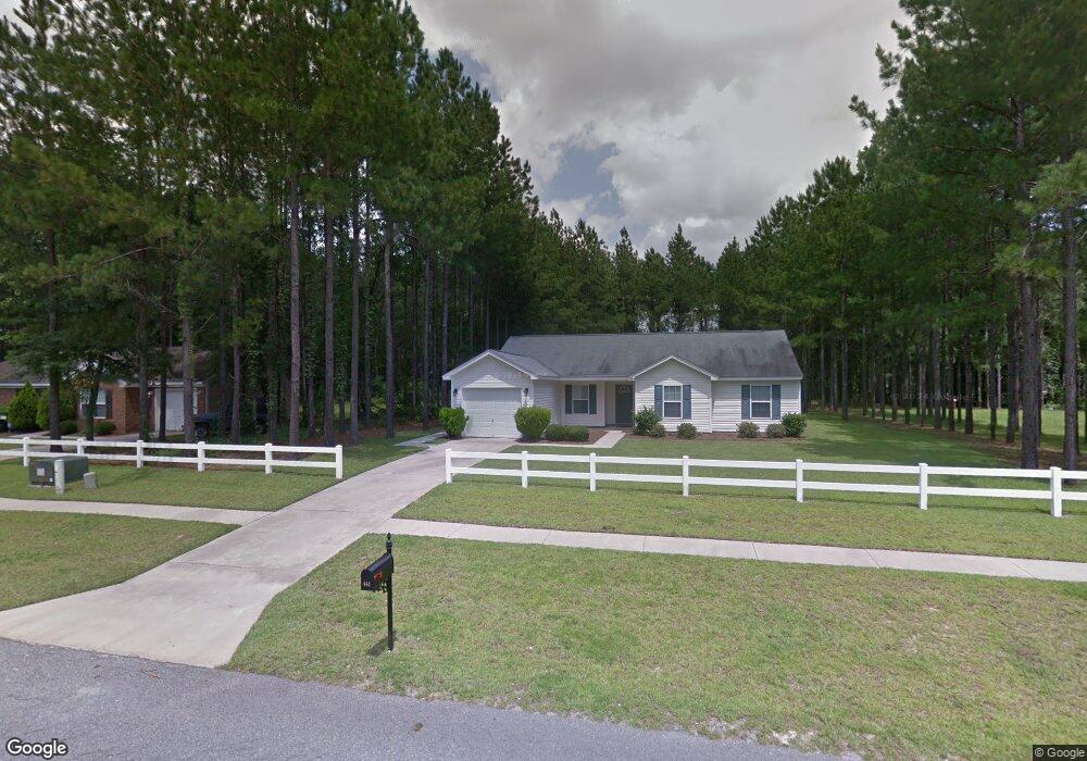
444 Shadowbrook Cir Springfield, GA 31329
Estimated Value: $241,000 - $290,000
3
Beds
2
Baths
1,373
Sq Ft
$190/Sq Ft
Est. Value
About This Home
This home is located at 444 Shadowbrook Cir, Springfield, GA 31329 and is currently estimated at $261,130, approximately $190 per square foot. 444 Shadowbrook Cir is a home located in Effingham County with nearby schools including Ebenezer Elementary School, Effingham County Middle School, and Effingham County High School.
Ownership History
Date
Name
Owned For
Owner Type
Purchase Details
Closed on
Nov 4, 2011
Sold by
Baer Deborah A
Bought by
Lee Isaiah
Current Estimated Value
Home Financials for this Owner
Home Financials are based on the most recent Mortgage that was taken out on this home.
Original Mortgage
$91,734
Outstanding Balance
$62,094
Interest Rate
4.02%
Mortgage Type
New Conventional
Estimated Equity
$199,036
Purchase Details
Closed on
Dec 3, 2007
Sold by
Jenkins & Jenkins Llc
Bought by
Baer Deborah A
Create a Home Valuation Report for This Property
The Home Valuation Report is an in-depth analysis detailing your home's value as well as a comparison with similar homes in the area
Home Values in the Area
Average Home Value in this Area
Purchase History
| Date | Buyer | Sale Price | Title Company |
|---|---|---|---|
| Lee Isaiah | $89,900 | -- | |
| Baer Deborah A | $138,900 | -- |
Source: Public Records
Mortgage History
| Date | Status | Borrower | Loan Amount |
|---|---|---|---|
| Open | Lee Isaiah | $91,734 |
Source: Public Records
Tax History
| Year | Tax Paid | Tax Assessment Tax Assessment Total Assessment is a certain percentage of the fair market value that is determined by local assessors to be the total taxable value of land and additions on the property. | Land | Improvement |
|---|---|---|---|---|
| 2025 | $1,653 | $95,008 | $22,800 | $72,208 |
| 2024 | $1,653 | $89,749 | $22,800 | $66,949 |
| 2023 | $913 | $79,805 | $17,600 | $62,205 |
| 2022 | $1,375 | $67,341 | $15,200 | $52,141 |
| 2021 | $1,329 | $59,414 | $14,400 | $45,014 |
| 2020 | $1,305 | $54,129 | $10,000 | $44,129 |
| 2019 | $1,309 | $54,129 | $10,000 | $44,129 |
| 2018 | $1,283 | $49,718 | $8,800 | $40,918 |
| 2017 | $1,288 | $49,718 | $8,800 | $40,918 |
| 2016 | $1,237 | $49,051 | $8,800 | $40,251 |
| 2015 | -- | $46,651 | $6,400 | $40,251 |
| 2014 | -- | $43,340 | $6,400 | $36,940 |
| 2013 | -- | $33,174 | $1,200 | $31,974 |
Source: Public Records
Map
Nearby Homes
- 487 Shadowbrook Cir
- 475 Shadowbrook Cir
- 119 Blackwater Way
- 560 Log Landing Rd
- 106 Blackwater Way
- 90 Mossy Oak Dr
- 300 White Willow Ct
- 101 Black Pine Dr
- 109 Knotty Pine Cir
- 126 Knotty Pine Cir
- 116 Alexander Trail
- 123 Alexander Trail
- 108 Alexander Trail
- 124 Jennie Dr
- 104 Alexander Trail
- 247 Lillian St
- 110 Cobbleton Dr
- 133 Cobbleton Dr
- 194 Cubbedge Dr
- 109 Cobbleton Dr
- 446 Shadowbrook Cir
- 442 Shadowbrook Cir
- 493 Shadowbrook Cir
- 503 Cypressridge Run Unit 39
- 503 Cypressridge Run
- 440 Shadowbrook Cir
- 495 Shadowbrook Cir
- 495 Shadowbrook Cir Unit 3
- 491 Shadowbrook Cir
- 505 Cypressridge Run
- 438 Shadowbrook Cir
- 400 Shadowbrook Cir
- 489 Shadowbrook Cir
- 501 Cypressridge Run
- 507 Cypressridge Run
- 402 Shadowbrook Cir
- 401 Shadowbrook Cir
- 509 Cypressridge Run
- 473 Shadowbrook Cir
- 511 Cypressridge Run
Your Personal Tour Guide
Ask me questions while you tour the home.