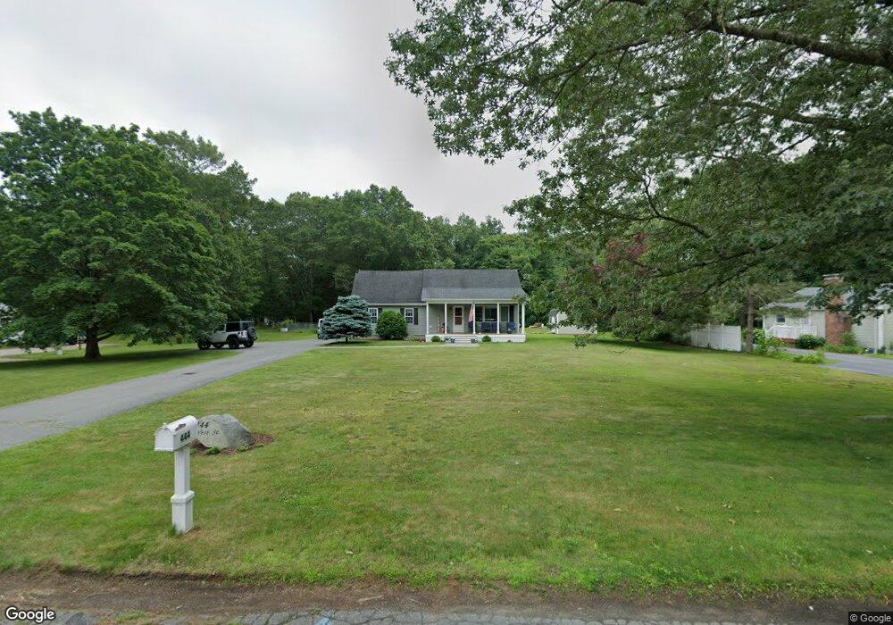
444 West St Mansfield, MA 02048
Estimated Value: $537,000 - $579,385
2
Beds
3
Baths
1,517
Sq Ft
$374/Sq Ft
Est. Value
About This Home
This home is located at 444 West St, Mansfield, MA 02048 and is currently estimated at $567,346, approximately $373 per square foot. 444 West St is a home located in Bristol County with nearby schools including Everett W. Robinson Elementary School, Jordan/Jackson Elementary School, and Harold L. Qualters Middle School.
Ownership History
Date
Name
Owned For
Owner Type
Purchase Details
Closed on
Aug 27, 2025
Sold by
Haddigan John F and Haddigan Jane B
Bought by
Rainbow West Irt and Haddigan
Current Estimated Value
Purchase Details
Closed on
Nov 14, 2003
Sold by
Dambra Jay Francis
Bought by
Holland Carolyn D and Haddigan John F
Purchase Details
Closed on
May 24, 1993
Sold by
Wynn Sandra J
Bought by
Francis Dambr Jay
Create a Home Valuation Report for This Property
The Home Valuation Report is an in-depth analysis detailing your home's value as well as a comparison with similar homes in the area
Home Values in the Area
Average Home Value in this Area
Purchase History
| Date | Buyer | Sale Price | Title Company |
|---|---|---|---|
| Rainbow West Irt | -- | -- | |
| Rainbow West Irt | -- | -- | |
| Holland Carolyn D | $298,000 | -- | |
| Holland Carolyn D | $298,000 | -- | |
| Francis Dambr Jay | $96,000 | -- | |
| Francis Dambr Jay | $96,000 | -- |
Source: Public Records
Mortgage History
| Date | Status | Borrower | Loan Amount |
|---|---|---|---|
| Previous Owner | Francis Dambr Jay | $200,000 | |
| Previous Owner | Francis Dambr Jay | $232,000 |
Source: Public Records
Tax History Compared to Growth
Tax History
| Year | Tax Paid | Tax Assessment Tax Assessment Total Assessment is a certain percentage of the fair market value that is determined by local assessors to be the total taxable value of land and additions on the property. | Land | Improvement |
|---|---|---|---|---|
| 2025 | $5,833 | $442,900 | $226,000 | $216,900 |
| 2024 | $5,958 | $441,300 | $226,000 | $215,300 |
| 2023 | $5,928 | $420,700 | $226,000 | $194,700 |
| 2022 | $5,748 | $378,900 | $209,300 | $169,600 |
| 2021 | $6,667 | $359,500 | $193,700 | $165,800 |
| 2020 | $5,327 | $346,800 | $193,700 | $153,100 |
| 2019 | $4,808 | $315,900 | $161,400 | $154,500 |
| 2018 | $4,189 | $293,000 | $146,300 | $146,700 |
| 2017 | $4,132 | $275,100 | $142,200 | $132,900 |
| 2016 | $4,073 | $264,300 | $142,400 | $121,900 |
| 2015 | $3,943 | $254,400 | $135,300 | $119,100 |
Source: Public Records
Map
Nearby Homes
- 450 West St
- 132 S High St
- 115 S High St
- 16 Bradner St
- 150 Rumford Ave Unit 222
- 241-243 N Main St
- 356 Central St
- 22 Pleasant St Unit B
- 22 Pleasant St Unit A
- 28 Court St
- 28 Court St Unit 4
- 16 East St Unit 2
- 38 Court St
- 21 East St Unit 1D
- 72 Court St Unit B
- 76 Samoset Ave
- 12 Wilson Place
- 60 King St
- 28 Angell St
- 99 Pleasant St