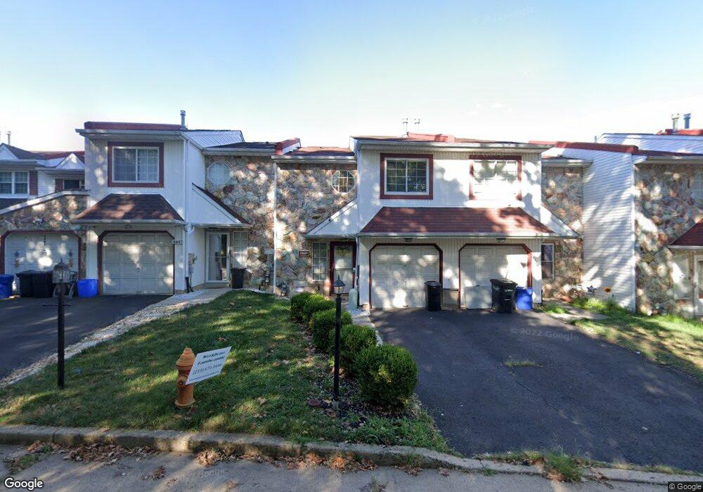
4449 Ernie Davis Cir Philadelphia, PA 19154
Northeast Philadelphia NeighborhoodEstimated Value: $343,646 - $387,000
3
Beds
3
Baths
1,470
Sq Ft
$245/Sq Ft
Est. Value
About This Home
This home is located at 4449 Ernie Davis Cir, Philadelphia, PA 19154 and is currently estimated at $360,412, approximately $245 per square foot. 4449 Ernie Davis Cir is a home located in Philadelphia County with nearby schools including A. L. Fitzpatrick School, George Washington High School, and School Lane Charter School.
Ownership History
Date
Name
Owned For
Owner Type
Purchase Details
Closed on
May 24, 2010
Sold by
Brown Treniese R and Brown Jeffrey A
Bought by
Munford Nicole
Current Estimated Value
Home Financials for this Owner
Home Financials are based on the most recent Mortgage that was taken out on this home.
Original Mortgage
$216,505
Outstanding Balance
$146,529
Interest Rate
5.25%
Mortgage Type
FHA
Estimated Equity
$213,883
Purchase Details
Closed on
Jan 15, 2004
Sold by
Guenzel Janet M
Bought by
Brown Treniese R and Brown Jeffrey A
Home Financials for this Owner
Home Financials are based on the most recent Mortgage that was taken out on this home.
Original Mortgage
$121,600
Interest Rate
5.89%
Mortgage Type
Purchase Money Mortgage
Purchase Details
Closed on
Oct 25, 1994
Sold by
Weng Jian and Li Jiayun
Bought by
Guenzel Janet M
Create a Home Valuation Report for This Property
The Home Valuation Report is an in-depth analysis detailing your home's value as well as a comparison with similar homes in the area
Home Values in the Area
Average Home Value in this Area
Purchase History
| Date | Buyer | Sale Price | Title Company |
|---|---|---|---|
| Munford Nicole | $220,500 | None Available | |
| Brown Treniese R | $152,000 | -- | |
| Guenzel Janet M | $95,500 | -- |
Source: Public Records
Mortgage History
| Date | Status | Borrower | Loan Amount |
|---|---|---|---|
| Open | Munford Nicole | $216,505 | |
| Previous Owner | Brown Treniese R | $121,600 | |
| Closed | Brown Treniese R | $22,800 |
Source: Public Records
Tax History Compared to Growth
Tax History
| Year | Tax Paid | Tax Assessment Tax Assessment Total Assessment is a certain percentage of the fair market value that is determined by local assessors to be the total taxable value of land and additions on the property. | Land | Improvement |
|---|---|---|---|---|
| 2025 | $3,353 | $314,700 | $62,940 | $251,760 |
| 2024 | $3,353 | $314,700 | $62,940 | $251,760 |
| 2023 | $3,353 | $239,500 | $47,900 | $191,600 |
| 2022 | $2,195 | $194,500 | $47,900 | $146,600 |
| 2021 | $2,825 | $0 | $0 | $0 |
| 2020 | $2,825 | $0 | $0 | $0 |
| 2019 | $2,660 | $0 | $0 | $0 |
| 2018 | $2,310 | $0 | $0 | $0 |
| 2017 | $2,730 | $0 | $0 | $0 |
| 2016 | $2,310 | $0 | $0 | $0 |
| 2015 | $2,211 | $0 | $0 | $0 |
| 2014 | -- | $195,000 | $59,487 | $135,513 |
| 2012 | -- | $22,496 | $3,291 | $19,205 |
Source: Public Records
Map
Nearby Homes
- 4471 Ernie Davis Cir
- 4274 Lawnside Rd
- 1742 Paradise Ln
- 4207 Fairdale Rd
- 4208 Greenmount Rd
- 1155 Regina Ave
- 1236 Whittier Ave
- 4374 Deerpath Ln
- 4122 Fairdale Rd
- 221 Ridgefield Rd
- 1126 Evelyn Ave
- 102 Village Ln
- 124 Meadow Ln
- 11125 Kirby Dr
- 12008 Elmore Rd
- 1032 Sunset Ln
- 4161 Orchard Ln
- 1202 Clinton Ave
- 3850 Woodhaven Rd Unit 302
- 3850 Woodhaven Rd Unit 504
- 4451 Ernie Davis Cir
- 4447 Ernie Davis Cir
- 4445 Ernie Davis Cir
- 4453 Ernie Davis Cir
- 4443 Ernie Davis Cir
- 4455 Ernie Davis Cir
- 4457 Ernie Davis Cir
- 4441 Ernie Davis Cir
- 4459 Ernie Davis Cir
- 4439 Ernie Davis Cir
- 4437 Ernie Davis Cir
- 4461 Ernie Davis Cir
- 4463 Ernie Davis Cir
- 4433 Ernie Davis Cir
- 4465 Ernie Davis Cir
- 4431 Ernie Davis Cir
- 4429 Ernie Davis Cir
- 4427 Ernie Davis Cir
- 4467 Ernie Davis Cir
- 4474 Ernie Davis Cir