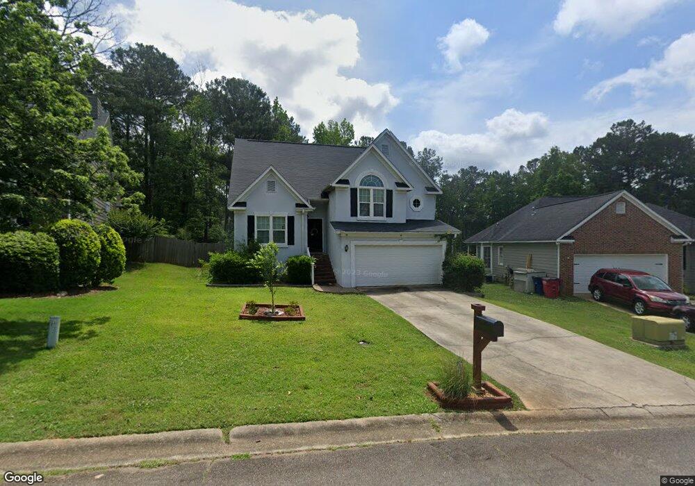
445 Ashville Dr Macon, GA 31210
Estimated Value: $199,000 - $248,000
3
Beds
3
Baths
1,544
Sq Ft
$141/Sq Ft
Est. Value
About This Home
This home is located at 445 Ashville Dr, Macon, GA 31210 and is currently estimated at $218,430, approximately $141 per square foot. 445 Ashville Dr is a home located in Bibb County with nearby schools including Springdale Elementary School, Howard Middle School, and Howard High School.
Ownership History
Date
Name
Owned For
Owner Type
Purchase Details
Closed on
Apr 16, 2010
Sold by
Samuelson Melanie M
Bought by
Schnake Jon P
Current Estimated Value
Home Financials for this Owner
Home Financials are based on the most recent Mortgage that was taken out on this home.
Original Mortgage
$142,373
Outstanding Balance
$93,842
Interest Rate
4.87%
Mortgage Type
FHA
Estimated Equity
$124,588
Purchase Details
Closed on
Sep 10, 2005
Bought by
Samuelson Melanie
Purchase Details
Closed on
Aug 8, 2003
Create a Home Valuation Report for This Property
The Home Valuation Report is an in-depth analysis detailing your home's value as well as a comparison with similar homes in the area
Home Values in the Area
Average Home Value in this Area
Purchase History
| Date | Buyer | Sale Price | Title Company |
|---|---|---|---|
| Schnake Jon P | $145,000 | None Available | |
| Samuelson Melanie | -- | -- | |
| -- | $132,000 | -- |
Source: Public Records
Mortgage History
| Date | Status | Borrower | Loan Amount |
|---|---|---|---|
| Open | Schnake Jon P | $142,373 |
Source: Public Records
Tax History Compared to Growth
Tax History
| Year | Tax Paid | Tax Assessment Tax Assessment Total Assessment is a certain percentage of the fair market value that is determined by local assessors to be the total taxable value of land and additions on the property. | Land | Improvement |
|---|---|---|---|---|
| 2025 | $1,733 | $77,536 | $12,000 | $65,536 |
| 2024 | $1,719 | $74,690 | $12,000 | $62,690 |
| 2023 | $1,067 | $66,996 | $10,000 | $56,996 |
| 2022 | $1,979 | $64,176 | $10,170 | $54,006 |
| 2021 | $1,967 | $58,768 | $9,450 | $49,318 |
| 2020 | $2,010 | $58,768 | $9,450 | $49,318 |
| 2019 | $1,771 | $52,243 | $8,550 | $43,693 |
| 2018 | $2,888 | $52,169 | $8,550 | $43,619 |
| 2017 | $1,518 | $47,517 | $7,650 | $39,867 |
| 2016 | $1,402 | $47,517 | $7,650 | $39,867 |
| 2015 | $1,985 | $47,517 | $7,650 | $39,867 |
| 2014 | $1,988 | $47,517 | $7,650 | $39,867 |
Source: Public Records
Map
Nearby Homes
- 199 Springfield Blvd
- 178 Springfield Blvd
- 108 Hillbrooke Ct
- 150 Springdale Ct
- 1297 Wesleyan Dr
- 200 N Wesleyan Cir
- 171 Lake View Dr N
- 115 Saddle Run Ct
- 123 Saddle Run Ct
- 1643 Wesleyan Hills Dr
- 5341 Northside Dr
- 920 Wesleyan Dr
- 5161 Wesleyan Cir
- 4964 Kathryn Dr
- 5369 Rivoli Dr
- 4661 N Beechwood Dr
- 1231 Woodcrest Dr
- 4726 Cheryle Ann Dr
- 1475 Maplewood Dr
- 135 Chadwick Dr
- 449 Ashville Dr
- 441 Ashville Dr
- 451 Ashville Dr
- 451 Ashville Dr Unit 316
- 439 Ashville Dr
- 448 Ashville Dr
- 432 Ashville Dr
- 455 Ashville Dr
- 435 Ashville Dr
- 428 Ashville Dr
- 0 Ashville Dr Unit 7289048
- 459 Ashville Dr
- 197 Springfield Blvd
- 433 Ashville Dr
- 422 Ashville Dr
- 425 Ashville Dr
- 195 Springfield Blvd
- 418 Ashville Dr
- 198 Springfield Blvd
- 421 Ashville Dr