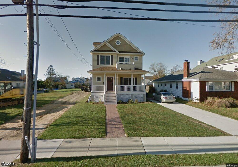
445 Main St Manasquan, NJ 08736
Estimated Value: $1,522,000 - $1,859,662
3
Beds
2
Baths
2,572
Sq Ft
$646/Sq Ft
Est. Value
About This Home
This home is located at 445 Main St, Manasquan, NJ 08736 and is currently estimated at $1,662,416, approximately $646 per square foot. 445 Main St is a home located in Monmouth County with nearby schools including Manasquan Elementary School, Manasquan High School, and St. Catharine School.
Ownership History
Date
Name
Owned For
Owner Type
Purchase Details
Closed on
Jul 19, 2016
Sold by
Shore Shack Too Llc
Bought by
Hoffman Constance J and Schwartz Robert K
Current Estimated Value
Home Financials for this Owner
Home Financials are based on the most recent Mortgage that was taken out on this home.
Interest Rate
3.42%
Purchase Details
Closed on
Jun 28, 2011
Sold by
Hoffman Constance
Bought by
Shore Shack Too Llc
Purchase Details
Closed on
Nov 24, 1998
Sold by
Kowalski Robert
Bought by
Hoffman Timothy and Hoffman Constance
Home Financials for this Owner
Home Financials are based on the most recent Mortgage that was taken out on this home.
Original Mortgage
$90,000
Interest Rate
6.8%
Create a Home Valuation Report for This Property
The Home Valuation Report is an in-depth analysis detailing your home's value as well as a comparison with similar homes in the area
Home Values in the Area
Average Home Value in this Area
Purchase History
| Date | Buyer | Sale Price | Title Company |
|---|---|---|---|
| Hoffman Constance J | -- | -- | |
| Shore Shack Too Llc | -- | Old Republic National Title | |
| Hoffman Timothy | $1,700,000 | -- |
Source: Public Records
Mortgage History
| Date | Status | Borrower | Loan Amount |
|---|---|---|---|
| Closed | Hoffman Constance J | -- | |
| Previous Owner | Hoffman Timothy | $90,000 |
Source: Public Records
Tax History
| Year | Tax Paid | Tax Assessment Tax Assessment Total Assessment is a certain percentage of the fair market value that is determined by local assessors to be the total taxable value of land and additions on the property. | Land | Improvement |
|---|---|---|---|---|
| 2025 | $11,130 | $626,000 | $281,800 | $344,200 |
| 2024 | $10,711 | $626,000 | $281,800 | $344,200 |
| 2023 | $10,711 | $626,000 | $281,800 | $344,200 |
| 2022 | $10,310 | $626,000 | $281,800 | $344,200 |
| 2021 | $10,310 | $626,000 | $281,800 | $344,200 |
| 2020 | $10,166 | $626,000 | $281,800 | $344,200 |
| 2019 | $9,784 | $626,000 | $281,800 | $344,200 |
| 2018 | $9,565 | $626,000 | $281,800 | $344,200 |
| 2017 | $9,202 | $626,000 | $281,800 | $344,200 |
| 2016 | $8,958 | $626,000 | $281,800 | $344,200 |
| 2015 | $10,133 | $592,900 | $256,500 | $336,400 |
| 2014 | $10,121 | $592,900 | $256,500 | $336,400 |
Source: Public Records
Map
Nearby Homes
- 43 Pearce Ct
- 355 Cedar Ave
- 207 4th Ave
- 22 Crescent Dr
- 329 Fisk Ave
- 323-325 Fisk Ave
- 130 Union Ave
- 217 Neptune Place
- 219 Neptune Place
- 610 Agnes Ave
- 11 Pearce Ave
- 205 Stockton Blvd
- 65 Pearce Ave
- 300 Washington Blvd
- 51-53 Main St
- 23 Ocean Ave N
- 38 Gertrude Place
- 802 4th Ave
- 800 4th Ave
- 504 Crescent Pkwy