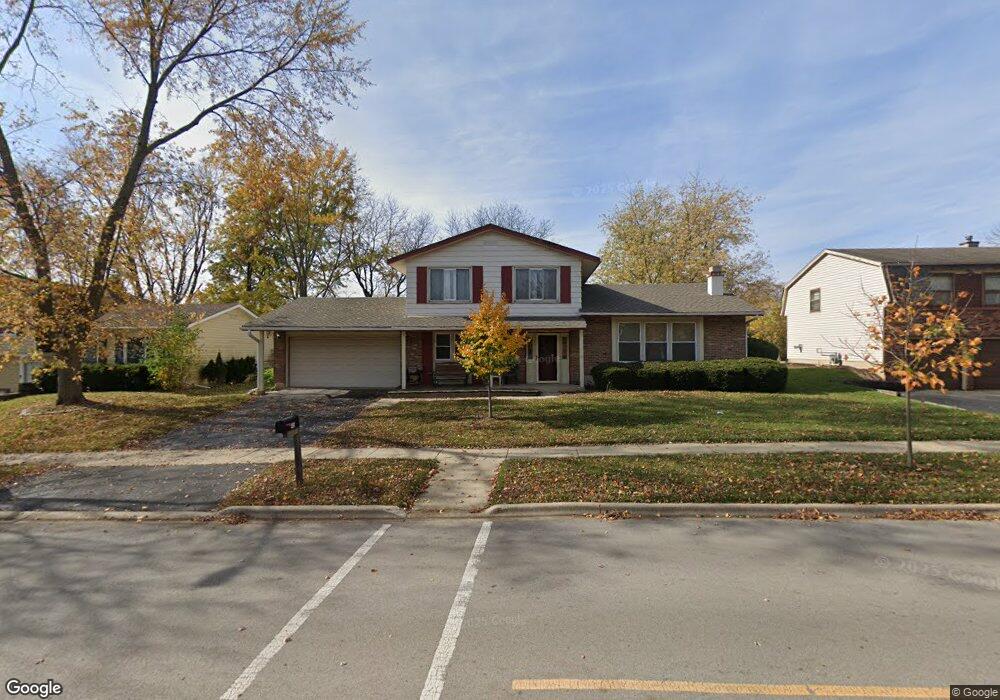
445 N Pinecrest Rd Bolingbrook, IL 60440
East Bolingbrook NeighborhoodEstimated Value: $336,619 - $375,000
3
Beds
3
Baths
1,915
Sq Ft
$186/Sq Ft
Est. Value
About This Home
This home is located at 445 N Pinecrest Rd, Bolingbrook, IL 60440 and is currently estimated at $356,905, approximately $186 per square foot. 445 N Pinecrest Rd is a home located in Will County with nearby schools including Jonas E Salk Elementary School, Hubert H Humphrey Middle School, and Brooks Middle School.
Ownership History
Date
Name
Owned For
Owner Type
Purchase Details
Closed on
Jun 28, 2016
Sold by
Phillips Loretta M
Bought by
Phillips Loretta M and Loretta M Phillips Living Trus
Current Estimated Value
Purchase Details
Closed on
May 30, 1995
Sold by
Meyer Kurt W and Meyer Kay B
Bought by
Phillips Randall D and Phillips Loretta M
Home Financials for this Owner
Home Financials are based on the most recent Mortgage that was taken out on this home.
Original Mortgage
$107,900
Interest Rate
8.26%
Create a Home Valuation Report for This Property
The Home Valuation Report is an in-depth analysis detailing your home's value as well as a comparison with similar homes in the area
Home Values in the Area
Average Home Value in this Area
Purchase History
| Date | Buyer | Sale Price | Title Company |
|---|---|---|---|
| Phillips Loretta M | -- | Attorney | |
| Phillips Randall D | $135,000 | -- |
Source: Public Records
Mortgage History
| Date | Status | Borrower | Loan Amount |
|---|---|---|---|
| Closed | Phillips Randall D | $107,900 |
Source: Public Records
Tax History
| Year | Tax Paid | Tax Assessment Tax Assessment Total Assessment is a certain percentage of the fair market value that is determined by local assessors to be the total taxable value of land and additions on the property. | Land | Improvement |
|---|---|---|---|---|
| 2024 | $8,050 | $105,198 | $19,139 | $86,059 |
| 2023 | $8,050 | $92,621 | $17,221 | $75,400 |
| 2022 | $7,167 | $83,503 | $15,526 | $67,977 |
| 2021 | $4,651 | $78,077 | $14,517 | $63,560 |
| 2020 | $4,673 | $75,510 | $14,040 | $61,470 |
| 2019 | $6,285 | $71,914 | $13,371 | $58,543 |
| 2018 | $4,799 | $66,164 | $12,302 | $53,862 |
| 2017 | $5,420 | $62,715 | $11,661 | $51,054 |
| 2016 | $4,961 | $59,700 | $11,100 | $48,600 |
| 2015 | $5,682 | $57,200 | $10,600 | $46,600 |
| 2014 | $5,682 | $57,200 | $10,600 | $46,600 |
| 2013 | $5,682 | $56,100 | $10,400 | $45,700 |
Source: Public Records
Map
Nearby Homes
- 354 Aaron Ln
- 598 Miner Dr
- 421 N Ashbury Ave
- 411 Assembly Dr
- 526 King Arthur Way
- 458 Wyeth Cir
- 404 Galahad Rd
- 555 Monroe Rd
- 424 Van Gogh Cir Unit 1
- 417 Monet Cir
- 316 Bedford Rd
- 325 Rockhurst Rd
- 7 Purchase Ct
- 490 Ridge Ln
- 519 Charlestown Dr
- 462 Ridge Ln
- 460 Ridge Ln
- 220 N Ashbury Ave
- 207 Seabury Rd
- 456 Ridge Ln
- 449 N Pinecrest Rd
- 441 N Pinecrest Rd
- 496 Nassau Ave
- 500 Nassau Ave
- 501 N Pinecrest Rd
- 437 N Pinecrest Rd
- 492 Nassau Ave
- 504 Nassau Ave
- 430 Faversham Ct Unit 5
- 436 N Pinecrest Rd
- 488 Nassau Ave Unit 5
- 508 Nassau Ave
- 433 N Pinecrest Rd
- 505 N Pinecrest Rd
- 431 Rothbury Dr
- 434 Faversham Ct
- 432 N Pinecrest Rd
- 497 Nassau Ave
- 484 Nassau Ave
- 501 Nassau Ave
Your Personal Tour Guide
Ask me questions while you tour the home.