Estimated Value: $206,654 - $237,000
3
Beds
3
Baths
1,676
Sq Ft
$132/Sq Ft
Est. Value
About This Home
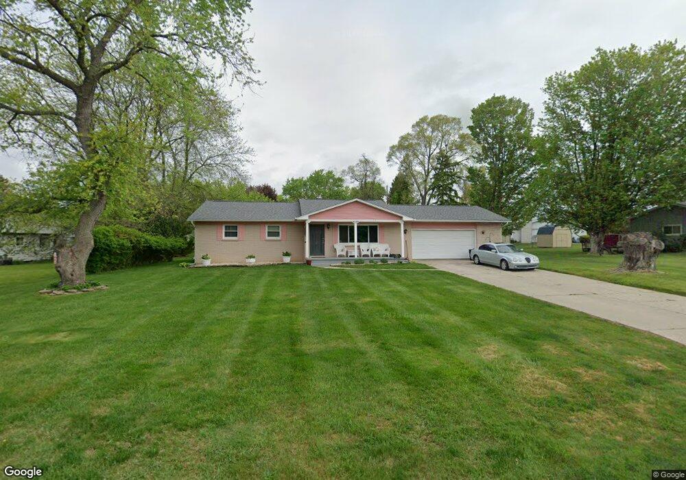
This home is located at 4450 Post Dr, Flint, MI 48532 and is currently estimated at $221,664, approximately $132 per square foot. 4450 Post Dr is a home located in Genesee County with nearby schools including Carman-Ainsworth High School, Genesee STEM Academy, and Linden Charter Academy.
Ownership History
Date
Name
Owned For
Owner Type
Purchase Details
Closed on
Apr 29, 2013
Sold by
Edwards Sharon Denise
Bought by
Sharon D Edwards Revocable Trust
Current Estimated Value
Purchase Details
Closed on
Sep 2, 2006
Sold by
French Robert and French Robert F
Bought by
Edwards Sharon D and French Sharon D
Home Financials for this Owner
Home Financials are based on the most recent Mortgage that was taken out on this home.
Original Mortgage
$124,800
Interest Rate
6.45%
Mortgage Type
Purchase Money Mortgage
Purchase Details
Closed on
Sep 29, 2004
Sold by
Walker Robert and Walker Ruth B
Bought by
Bank Of New York
Create a Home Valuation Report for This Property
The Home Valuation Report is an in-depth analysis detailing your home's value as well as a comparison with similar homes in the area
Home Values in the Area
Average Home Value in this Area
Purchase History
| Date | Buyer | Sale Price | Title Company |
|---|---|---|---|
| Sharon D Edwards Revocable Trust | -- | None Available | |
| Edwards Sharon D | -- | Landmark Title Services Inc | |
| Bank Of New York | $130,500 | -- |
Source: Public Records
Mortgage History
| Date | Status | Borrower | Loan Amount |
|---|---|---|---|
| Previous Owner | Edwards Sharon D | $124,800 |
Source: Public Records
Tax History
| Year | Tax Paid | Tax Assessment Tax Assessment Total Assessment is a certain percentage of the fair market value that is determined by local assessors to be the total taxable value of land and additions on the property. | Land | Improvement |
|---|---|---|---|---|
| 2025 | $2,646 | $93,900 | $0 | $0 |
| 2024 | $1,492 | $90,800 | $0 | $0 |
| 2023 | $1,154 | $84,700 | $0 | $0 |
| 2022 | $1,037 | $77,500 | $0 | $0 |
| 2021 | $2,089 | $71,800 | $0 | $0 |
| 2020 | $1,365 | $59,800 | $0 | $0 |
| 2019 | $1,022 | $55,600 | $0 | $0 |
| 2018 | $2,446 | $54,700 | $0 | $0 |
| 2017 | $1,877 | $54,700 | $0 | $0 |
| 2016 | $2,370 | $47,300 | $0 | $0 |
| 2015 | $1,716 | $45,000 | $0 | $0 |
| 2014 | $1,018 | $43,100 | $0 | $0 |
| 2012 | -- | $43,400 | $43,400 | $0 |
Source: Public Records
Map
Nearby Homes
- 1090 Cabot Dr
- 1095 Devenish Ln
- 1034 Normandy Terrace Dr
- 1246 Dyemeadow Ln
- 1368 Autumn Dr
- 5021 Forest Side Dr
- 000 Devenish Ln
- 2 Charter Dr
- 1161 S Dye Rd
- 4075 Townview Dr
- 0 Charter Dr Unit 50153638
- 2008 Beekman Ct
- 1137 S Graham Rd
- Graham Rd N Graham Rd
- 2174 Mill Rd
- 4022 Beecher Rd
- 3.9 Acres W Court St
- 4199 Sheraton Dr
- 3528 Beecher Rd
- 5477 Fernwood Dr
Your Personal Tour Guide
Ask me questions while you tour the home.